
|
|
SUBSIM: The Web's #1 resource for all submarine & naval simulations since 1997
|
SUBSIM: The Web's #1 resource for all submarine & naval simulations since 1997 |
 01-08-11, 06:30 PM
|
#3736 |
|
Stowaway
Posts: n/a
Downloads:
Uploads:
|
It's a WIP right now.
Here's a couple more shots of it.  
|

|
|
01-09-11, 05:32 AM
|
#3737 |
|
Ace of the Deep
 Join Date: Oct 2006
Posts: 1,151
Downloads: 152
Uploads: 0

|
That's the sweetest little thing! Very cool!

|

|
|
|
01-09-11, 06:53 AM
|
#3738 |
|
Sea Lord
Join Date: May 2006
Location: 5 Miles Inland West Of Lake Huron
Posts: 1,936
Downloads: 139
Uploads: 0
|
Wow Privateer! Nice work! Just need a few more souls in the boat, and it would look even better! more oars and all. That would make it even more authentic looking than it does!
Seriously though, that lifeboat looks fantastic! Hope to see it soon as an addition to the game!
__________________
A legislative act contrary to the Constitution is not law. -John Marshall Chief Justice of the Supreme Court --------------------- |
|
|
|
|
01-10-11, 01:10 AM
|
#3739 |
|
Stowaway
Posts: n/a
Downloads:
Uploads:
|
It needs scaled down just a little bit more yet.
I also have been adjusting the UV's on the oars used by the rowers. The oars get the color from the sleeve of the rower.  We can not just export, adjust, then import them. Skeletal animations you know. So it's being done by hexing the UV's in the dat itself. |
|
|
|
01-10-11, 02:51 PM
|
#3740 |
|
Sea Lord
Join Date: May 2006
Location: 5 Miles Inland West Of Lake Huron
Posts: 1,936
Downloads: 139
Uploads: 0
|
Ok, I can understand that. Did a little modelling for a WWI sim I like to fly, and for my first project ever, I built a 2 seater biplane, which was a bit much to bite off and chew, but it was fun none the less. Learned a lot real quick about moving parts, and interior and exterior parts back to back.
Would like to get back to modelling some more planes, but there are too many projects on the farm right now. Or ranch, oh heck, 5 acres is a lot to care for by yourself.
__________________
A legislative act contrary to the Constitution is not law. -John Marshall Chief Justice of the Supreme Court --------------------- |
|
|
|
|
01-10-11, 07:54 PM
|
#3741 |
|
Stowaway
Posts: n/a
Downloads:
Uploads:
|
I'm just going to change the texture the faces are pointed to and add a small texture.
That's the quickest and easiest way to do it. Why it's set up the way it is? 
|
|
|
|
01-12-11, 02:22 PM
|
#3742 |
|
Ace of the Deep
Join Date: Sep 2010
Location: LA Area, Central coast, California
Posts: 1,023
Downloads: 827
Uploads: 0
|
 YES!! Had to share. I ran across this small convoy, 4 DD's protecting something but I couldn't see what the heck it was. I found out shortly, and 18000 ton Passenger Liner. Very exciting sneeking in from the starboard side waiting to be spotted by the front and starboard Escorts. We brought her in to 3000 yrds. Silent Running. No reaction from the escorts till the fish were halfway there then we bugged out. All four hit, three exploded. Ship sunk after a time. Sweet Night! YES!! Had to share. I ran across this small convoy, 4 DD's protecting something but I couldn't see what the heck it was. I found out shortly, and 18000 ton Passenger Liner. Very exciting sneeking in from the starboard side waiting to be spotted by the front and starboard Escorts. We brought her in to 3000 yrds. Silent Running. No reaction from the escorts till the fish were halfway there then we bugged out. All four hit, three exploded. Ship sunk after a time. Sweet Night!Thanks for indulging me. (You can just make out some fish on their way in the first pic) D40/Uss Stingray/ Luzon Strait   
__________________
Dogfish40 |
|
|
|
|
01-12-11, 02:35 PM
|
#3743 | |
|
Ace of the Deep
Join Date: Sep 2010
Location: LA Area, Central coast, California
Posts: 1,023
Downloads: 827
Uploads: 0
|
Quote:
Good Hunting D40
__________________
Dogfish40 |
|
|
|
|
|
01-13-11, 06:44 AM
|
#3744 |
|
Ensign
 Join Date: Jul 2010
Location: Corinth, MS
Posts: 231
Downloads: 116
Uploads: 0
|
Started my first campaign in Silent Hunter 4 today. Picked the Asiatic Fleet and managed to sink 4 ships for almost 21,000 tons.
-Lt. Cdr. Matt Ellzey Commanding Officer, U.S.S. Sargo (SS-188)
__________________
"It does not matter how the enemy travels, in convoy, in pairs, or alone...I will find him and sink him wherever he is." 
|
|
|
|
|
01-22-11, 09:48 PM
|
#3745 |
|
Swabbie
 Join Date: Dec 2010
Location: Reno,Nevada
Posts: 13
Downloads: 78
Uploads: 0
|
While on patrol managed to sink 2 nippon maru and 3 buzyn maru with a destroyer to close the patrol..Enroute to midway i was jumped by 3 destroyers..All crewmen in aft torpedo room an engine rooms wounded..No purple hearts..What happened??

__________________
There are only two conditions that must be met before your enemies attack you..When they are ready,and you are not.. 
Last edited by delta 6; 01-24-11 at 03:58 PM. |
|
|
|
|
01-26-11, 02:12 AM
|
#3746 |
|
Sonar Guy
 
Join Date: Jul 2003
Location: Edmond, Oklahoma
Posts: 390
Downloads: 500
Uploads: 0
|
Here are some shots of the "Flying Dutchman". Found her sailing around Johnston Island.
 CW       
__________________
"Quando omni flunkus moritati"  United States Navy 1979-1982 "AD2" Aviation Machinists Mate 2nd Class VT-23, HS-1, USS Carl Vinson CVN70 (Plank Owner) NAS Kingsville, TX; NAS Jacksonville, FL; NOB Norfolk, VA FAA Air Traffic Control Specialist, Fairbanks, AK 2000-2020 (Ret) |
|
|
|
|
01-31-11, 06:23 PM
|
#3747 | |
|
Ace of the Deep
Join Date: Oct 2005
Location: BA 72
Posts: 1,092
Downloads: 43
Uploads: 0
|
Quote:
__________________

|
|
|
|
|
|
02-02-11, 07:30 AM
|
#3748 |
|
Commodore
 Join Date: Feb 2010
Posts: 615
Downloads: 199
Uploads: 0
|
My greatest patrol
I'm patrolling the Marshall Islands, it's a dark and some what quiet morning..
It's 03:21 am, We've just had a contact update towards heading down towards Maloeplap Atoll from Likiep Atoll. These Islands are swarming with Japanese naval patrol boats that are constantly on patrol throughout the Atoll's. As we set course for Erikub Atoll that lies directly in the path that our contact is taking. "Ahead standard" I give my order and slowly we begin to speed up through the waters just off Namu Atoll. "Periscope depth" I order, and wait as we climb 20ft to the correct depth. I take a look out to see what the day might bring. 04:15 am We've been sailing at periscope depth since we got our contact update, and i have to say it's a strange feeling as we hear the planes buzzing around above us. It's like they can see us from up there, even though this water is pretty dark and there is no light for another few hours. 05:24 am The contact has suddenly changed course and is now heading out of the Marshall Islands and on a stable course for midway Island. "Ahead flank" I bellow at my crew. And the sub rattles and creeks as the engines go into overtime, we're now making a steady 21knots and Closing the gap between us and the freighter. 06:54 We're just 500 meters of the port bow of the freighter, I take a look through the periscope and to my dismay it's not just one but 5 closely grouped Oil reserve tankers heading for midway. "Sir, warship, distance: 300 meters and gaining!!" "Dive, set depth to 100 ft and rig for silent running!!" I bellow, the crew jump waste no time getting us to depth, and as we rig for silent running. "Splashes" my sonar man whispers. 07:12 am We've been dodging the sub-chaser for nearly 20 minutes and the damn thing only keeps getting closer to us. "Splashes" my sonar man repeats. The sub vibrates and jerks violently as the depth charges explode around us, wiping out our periscope and deck gun, taking out our radar and have stalled our engines. "passing 130ft, passing 140ft" We're loosing depth, we need to start our engines, damn things shudder and we're moving again, given it's only 5knots. But we're creeping along. "Enemy warship making another pass" "full right rudder, dive to 150ft and ready a damn fish" I demanded. The ship passes us but strangely does not drop any charges, we wait as she passes the 120 meter distance. "Fire!!" I order We wait but the sound of the launching torpedo does not come. "We can't launch a fish sir, the torpedo tubes are damaged, we need to make repairs" says my engineer. Great that's all we need, a submarine without weapons. "Match freighter speed and course, lets ride this out until well with allied air cover" For the next few hours we wait as the engineers work on the damage and weapons repairs. Well the repairs the can do without surfacing that it is. 15:43 pm We're not far from Johnston Atoll, Which isn't far from pearl harbour. I suspect we will be paid a visit from allied air cover before long. They won't let any Japanese force, military or merchant get close to that naval base.
__________________
 "A good Navy is not a provocation to war. It is the surest guaranty of peace." |
|
|
|
|
02-02-11, 01:59 PM
|
#3749 |
|
Helmsman
 Join Date: Apr 2007
Location: 500 Ft. Below the Surface
Posts: 105
Downloads: 883
Uploads: 0
|
   Sixth War Patrol July 29, 1944 - September 22, 1944 Lt.Commander Guy E. O'Neil, Commanding Officer Prologue After a brief stay in Fremantle Western Australia lasting from July 4th until the 19th, the GUNNEL once more headed out into harm's way. During her stay in Fremantle a refit was performed by the USS GRIFFIN and the members of Relief Crew, Division 121. Ships officers and crew left the ship for two weeks recreational leave in the Perth area during this period. On July 14, 1944 Lt.Commander. G.E.O'Neil, USN, assumed command of the GUNNEL, relieving Commander John S. McCain, USN. Commander McCain moved on to a new duty assignment after a very capable, rewarding and rigorous tour of duty. During his tenure he placed the GUNNEL in commission, trained a new crew, and completed 5 war patrols into enemy controlled waters from North Africa to Southeast Asia. At this time, Lieutenant Lloyd R. "Joe" Vasey, USN, who served initially as First Lieutenant and Torpedo and Gunnery Officer, and then for the majority of the subsequent war patrols as Executive Officer and Navigator, also received orders moving him on to a new duty assignment in submarines. Commander McCain remained in the service during the years following the war, ending his career as a four star Admiral in command of all US Forces in the Pacific region during the war in Vietnam. Lieutenant "Joe" Vasey also remained in the service after the war advancing to the rank of Rear Admiral, USN. Lieut. Clarence J. Zurcher, USNR, who had been serving as Torpedo and Gunnery Officer under Commander McCain, took over as the Executive Officer and Navigator under Lt.Commander O'Neil. Lieut.(jg) T.E. Stephens and Lieut.(jg) E.W. Murphy had been temporarily detached for a period of rest and for duty with the relief crew while the GUNNEL was out on the 5th patrol and they now returned. Lieut.(jg) Stephens relieved Lieut. Zurcher as Torpedo and Gunnery Officer, and Lieut.(jg) Murphy resumed his previous duties as First Lieutenant. Lieut.(jg) S.L.Knotts continued as Communication Officer. Other officers remaining unchanged in their assignments were Lieut. W.P. Robinson, Engineering and Diving Officer, Lieut.(jg) J.M. Thornton, Commissary, and Assistant Engineer, and Lieut.(jg) J.L. Shillansky Assistant Communications and Commissary Officer. At this time also CMoMM G.D. Hansen reported aboard to relieve CTM R. D. Pickard as Chief of the Boat. Chief Pickard received orders to return to the States as part of the commissioning crew for a new submarine being built. As earlier noted in these accounts of the GUNNEL war patrols, the paragraphs following which commence with time in bold face (date/times underlined) are excerpts from the Commanding Officer's official wartime Patrol Report and Deck Log submitted at the end of the patrol. These reports are now unclassified, and can be found in the official files of the U.S. Navy. To these original reports which follow, Guy O'Neil, Captain USN (Ret), who as Commanding Officer at that time held the rank of Lt.Comdr., USN, (hereafter Former C.O.), along with former members of the wartime crew, have added additional comments and recollections of that experience. These later additional comments are printed in Italics to distinguish them from the wartime narrative. Where possible, the names of the former members of the crew are noted, and attribution given to their recollections. Extensive research of the historical records has been made to insure the faithfulness of GUNNEL's story. Captain O'Neil and the editors welcome your comments and we take full responsibility for any omissions or inaccuracies. We especially encourage relevant submissions from former crewmembers and their families. The sixth patrol was conducted in the Sibuyan Sea area and off the west coasts of Southern Luzon and Mindoro Islands. The Official report follows: July 18, 1944: Refit completed. Regular ships officers and crew returned from leave. Commenced loading and completed minor items of repair. In addition to the normal refit the following work was accomplished. (Capt. O'Neil, former C.O.)"The system of refit and rest between patrols, set up early in the war, was a major contribution to the success of our Submarines. When the war commenced, the submarines in the Pacific and the Philippines were the first ships out of port to carry the war to the Japanese. It was very soon evident they were undermanned and, with the few available, overextended. Peacetime complement for the fleet class boat such as the GUNNEL, (the SALMON, SS182, was my home then) was five officers and 54 men. This manning level was sufficient for peacetime operations, three or four days at sea during most weeks, with often a whole week or two in port. Now we were out fifty-five to seventy days on our own, with only two weeks in port upon return to make repairs, resupply and get back on station. At sea, the men and officers spent their off watch hours, when not at battle stations,, in maintenance and repair of machinery. We ate and slept in the few hours left over. Upon return we had to accomplish our own refit, albeit with help from the tender, taking a few hours off when we could. When we went to sea again we were worn out. This situation fortunately soon changed. In my case, upon return from our third patrol, I believe early June, 1942, the submarine service had established a two week refit period for each submarine between war patrols, during which the officers and men were sent ashore to rest areas. Relief crews had been formed, made up of one quarter of each crew detached in rotation, plus replacements from the States, to accomplish the maintenance and repair work, while the remainder rested. Additional officers and men were added increasing the boat complements. Submarine Tenders, such as the U.S.S, GRIFFIN, provided all the support a major shipyard could offer with their heavy lift capability and mechanical, electrical, optical, and weapons shops." The patrol report continues:
"Jack McCain had requested shifting position of the attack scope, and I concurred. This was the primary scope used by the C.O. for submerged attack as it tapered at the top to a small diameter tube not easily seen. The other scope contained a radar antenna in addition to the optics and being bulky it was normally only used for an occasional last moment radar range before firing. As the torpedo data computer (TDC) was located adjacent the after scope, the attack scope needed to be shifted to the forward position so that the C.O. using that scope and the fire control party at the TDC weren't all trying to occupy the same space. (Former C.O.) "For those readers unfamiliar with submarines and the equipment we used to find and attack enemy shipping, the SJ radar was used for surface (ships) search. The antenna was mounted on the top of a vertical shaft in front of and at the top of the periscope shears and continually rotated in use. The picture presented at the receiver in the conning tower on a circular screen is now familiar to anyone who has seen war movies. Ship contacts appeared as spots of light, called "pips", and the number, distance, and true bearing of the ships in a convoy could be determined by measurement from the center of the screen. A second small screen, called the Plan Position Indicator (PPI), was used to show a small-magnified section of the main screen to examine in detail relative positions of the ships within a convoy. This was a great help in getting into a good firing position at night. as one could often recognize the escorts from the convoy itself by the size and relative location of the individual pips. Although the Japanese anti-submarine escorts did not have surface search radar detection systems, it was not the disadvantage it would appear to be. They had excellent optical equipment and well-trained lookouts, and despite our relative small silhouette at night, they could often see us first at distances we could not yet see them visually." "The SD was the aircraft search radar and its antenna was installed on top of a pole aft of the periscope shears. The receiver was mounted in the Control room and showed only the range to the contact, not the direction.. This was a somewhat crude but effective device, which saved our necks many a time. By the end of the war this was being replaced by the SV, which had a rotating antenna and showed both direction and range. During the war we all believed the Japanese had radar detection equipment installed in their aircraft, and could detect our air search radar and home in on our signal when we turned the radar on, so we normally sent brief pulses by keying at random intervals. After the war we found they had no such gear in use, it was just that they operated so many search aircraft in these areas that we naturally picked them up beyond visual range every time we turned the set on. We were not attracting them by using the radar." July 19, 1944: Underway, made a trim dive in operating area followed by sound tests in Cockburn Sound. "As we took in the lines and pulled away from the dock, I suddenly realized the loneliness of command. From this moment on, every action we took, every move we made, were my responsibilities. I would have help and advice, but the decisions were mine alone. In the five days since I spoke the words, 'I relieve you sir', to Jack McCain before the assembled crew, I had been observing them (and I'm sure they were looking at me). I felt confident that they and I were ready and capable for what was to come. I hoped they felt the same about me. The difficulty would be the gaining of their trust and confidence. Jack McCain was a tough act to follow. He was a strong character and I would do many things differently. In the crews mind this was still McCains boat, and I was an unknown, an outsider. There was a lot to be accomplished, and I started at once by leaning heavily on the new Exec, Lt. Jim Zurcher, and the new Chief of the Boat, CMoMM G.D. Hanson, for help, and they were up to the challenge. This was a well-trained crew, but there were changes I had to make. As a PCO (prospective Commanding Officer) waiting for assignment, I had prepared my Standing Order Book for guidance of the OOD watch standers, and I knew how I wanted the Fire Control Party to work. I put Jim Zurcher on this at once to assign the people and lay out their tasks to my way because once underway and past the entrance buoy the training exercises would start. Every ship contact, radar or visual made a good exercise for the tracking party who manned the TDC in the Conning Tower and the plotting table in the Control Room. Their job was to determine from radar, sonar, and visual bearings with ranges if available, the course and speed of a target vessel. With this information and observations I could make, I was responsible for putting the boat into a position to successfully launch torpedoes despite the best efforts of a very capable enemy force to prevent that. I also ordered surprise dives at odd and unexpected times, and I carried a stop watch to check the time it took to submerge to 52 feet, the depth at which the highest point of the periscope shears went under. As I remember now, a minute and a quarter from the time I or the OOD willed to dive was acceptable in normal Sea State, and I have seen it done in 42 seconds. Fire drills of course were frequently held which I initiated as I strolled through the boat, and power outages were arranged which required immediate shifting to hand operation of steering, and bow and stern planes submerged." (Former C.O.) July 21-22, 1944: Underway conducting individual ships exercises. "These drills became a night and day routine that I made sure we carried out without rest and repeated over and over until we were judged ready to go to war. Once we were in enemy waters there would be no forgiveness for mistakes." (Former C.O.) July 23-27, 1944: Underway conducting practice day and night torpedo approaches. July 25th took Commander Sub-Div 121 aboard and conducted coordinated search and attack exercises with USS MUSKALLUNGE and USS FLIER on escorted ship as target. July 27th fired three exercise torpedoes and returned to port to complete loading. Took on board 24 Mark 14 torpedoes to complete full load. "This training period at sea had been a work out for everybody, and I was about exhausted. This period was not only refresher training for the crew, it was graduation time for me. It was not too late to change the new C.O. and the Division Commander had to approve me as well as make the decision the boat was ready to go. We passed, It was go. The torpedoes fired were judged to be hits. Most importantly the torpedoes ran hot and straight and were recovered. It would have been most embarrassing to lose them. Exercise torpedoes were the regular torpedo but with an exercise head filled with sea water to give it the same weight. At the end of the run the air remaining in the torpedo air flask blew the head dry so that the torpedo would broach and float nose high for recovery and reuse. The Mark 14Torpedo was alchohol fueled, steam propelled, and could be set for two speeds; 46 knots, or 31-1/2 knots to a greater range. The warhead contained 668 pounds of Torpex, a sensitive and lethal explosive. With 6 tubes forward and 4 aft, we had all tubes loaded with one extra per tube. The torpedoes were supposed to be ready to go, but before we reached station each would be completely overhauled by our torpedomen who lived with them and were responsible for them." "At the time this patrol report was written, 1944, neither the other officers, the Torpedo gang, nor I were aware of all the flaws in the design and operation of the torpedoes and their detonators issued for our use. We knew the magnetic feature of the detonator was unreliable and was to be disconnected in all torpedoes. We also knew the torpedoes tended to run deeper than set, we were told 4 or more feet, and we were prepared to set depths shallower than desired depending upon target and sea state. We did not know of two fatal flaws in their design and performance. The actual depth the torpedo ran upon leaving the tube was variable; it sometimes was a series of deep, porpoising, dives up to a run of 1-2000 yards or more and than gradually approaching a mean running depth somewhat deeper than set. More importantly the mechanical detonator tended to jam upon a straight on or nearly so, hit (in fire control terms, a 90-degree track, a right angle.) thus failing to detonate the warhead. The detonator would most often work however if the torpedo hit at an angle to the target hull. Unfortunately I always tried to set up for a 90-track which was considered the best tactic." (Former C.O.) July 29, 1944, 1337(H): Underway in accordance with ComTaskForce 71 operation order #98-44 to conduct unrestricted submarine warfare against the enemy in the Sulu Sea. Routing via Darwin, East of Timor, Banda Sea, Molukka Passage, Celebes Sea and Sibutu Passage. "Once past the entrance buoy, I could now remove my sealed orders from the safe and read my instructions. Other than the route to take, the patrol area, and date to return home they were brief: 'Conduct unrestricted submarine warfare on enemy shipping'." (Former C.O.) 1540(H): Commenced coordinated attack exercises with USS NARWHAL against single ship convoy consisting of USS CHANTICLEER, USS ISABEL and HMAS DUBBO. During these exercises the SJ radar gave very poor performance. After tuning to peak performance while tracking convoy a maximum range of 6,000 yards only could be occasionally had on the CHANTICLEER. 2200(H): Completed convoy exercises and set course in bombing restriction lane proceeding independently for Darwin. Continued working on SJ Radar through the night until the trouble was found to be in the Pulser Box of the transmitter. The spare pulser box carried was found to be in an equally poor condition giving negligible output power. "We were supposedly safe from attack by friendly forces in these lanes. I made it clear to the lookouts however, they were to regard all aircraft and ships seen as hostile until proven otherwise." (Former C.O.) July 30, 1944 0140(H): #1 Main engine found to have a broken head stud and placed out of commission. #2 Main engine was found to have a leaking liner seal ring which was renewed from spares. "The following day, July 31, was uneventful as we continued at two engine cruising speed (15 knots) towards our scheduled stop in Darwin, West Australia. Most boats heading on patrol were scheduled, or allowed, to stop over briefly. It was not out of the way, and the cruise there provided a good shake down following the refit and training period just completed. I was thankful this time because we were having problems already with #1 and #2 Main engines, and using up our spares. Additional spare parts were available in Darwin. While enroute assigned station, I started each day that we would remain on the surface with a brief trim dive at the beginning of morning twilight. A submarine has to compensate for changes in weight due to fuel, water, torpedoes, and food used during any lengthy time spent on the surface to ensure the next dive, planned or unplanned, will be at neutral buoyancy and smartly accomplished. Daily trim dives ensure one is never far off. While submerged, the trim is continually adjusted so it is only during lengthy periods on the surface that the trim can get off. Compensation for weight changes is accomplished by pumping sea water in or out of the trim tanks, or between forward and after trim; because the boat can be too heavy or too light, but also out of balance overall. The Engineering Officer was responsible for maintaining this balance by keeping track of all weight changes and their moment arm and noting the changes in the Diving Book. Before the first dive out of port the compensation is calculated and adjustments made as part of the rig for dive procedure. One hopes the weight changes were correctly estimated, else one could find the boat plummeting to the bottom upon diving, or almost as bad unable to get under at all. The first trim dive after a refit is always interesting and sometimes embarrassing to the Engineering Officer if his estimates are badly off. One had to remember that fuel oil is lighter than water, thus fuel used, makes the boat heavier over time, and fuel taken on in port makes the boat lighter the next dive. While at sea, torpedoes fired make no difference in the trim because they are replaced by an equal weight of water flooding back into the tube, which in turn is pumped into the trim tanks as torpedoes are reloaded from the racks. New torpedoes taken aboard in port however make a tremendous change because of their weight and moment arm (distance of the tubes from the center of gravity). Computing the proper trim after a Navy Yard overhaul is practically impossible, and we usually chose an area with a sandy bottom and something less than 150 feet depth for that first divc. If we turned out to be too heavy, the Diving Officer was ready to blow everything and hope to stop the descent before hitting the bottom. If too light one merely had to flood auxiliary ballast until the boat got under and then refine the trim, all of course while enduring caustic remarks by the skipper." (Former C.O.) August 1, 1944 0925(H): (SC#1) Sighted Dutch K-14 Submarine on opposite course in position Latitude 20-20 S, Longitude 113-03 E. Exchanged recognition signals. "The Dutch Navy operated several of their submarines out of Freemantle against the Japanese. I had a lot of respect for them. The boats were small, hot, crowded and leaky, similar to our old K boat class, and had a limited range and endurance, but they did a good job. Earlier in the war I had a few drinks with one of the K-14 officers, and I remember we commiserated together about a mutual problem; our main engine exhaust valves leaked badly while submerged. As he expressed it "the bloody exhaust walves" continually leaked on every dive. Every time I saw one of their boats I wondered if they ever got that problem licked. The SALMON never did." (Former C.O.) 0943(H): (AC#1) While submerging for training made a plane contact on the SD Radar at 14 miles. Plane not seen. 1200(H): Position; Longitude 19-57 S, Latitude 113-10 E. 1417(H): Fired ten rounds 4" common ammunition from the deck gun and 60 rounds 20mm ammunition for each 20mm gun. A homemade target was constructed but it sank immediately on launching due to an overzealous auxiliary man stuffing in a large lead hammer to make it float upright. "This drill I remember went very well. Feeling pleased observing this drill. I saw no problems. Rudolph Velle, the Gun Captain and his crew worked smoothly in this practice shoot. They were obviously well trained. Dispersion of the fall of shot appeared normal for this type gun. The loading crew was working well bringing the ammo from the deck locker, and feeding the shells into the breech. Pointer and trainer were matching the slight roll and pitch. There was no indication of the trouble we were shortly to experience in a battle surface on an enemy target. We will never know, but my guess is the pointer's gun sight was not secured tightly following the last bore sighting during the refit, and this test firing jarred the sight off center without our knowing, causing the gun to shoot high later." (Former C.O.) 2215(H): Sent Gunnel #1. "This message reported our expected arrival time in Port Darwin on the northwestern tip of Australia and to request the radar and engine spares we needed before proceeding to our assigned area. I was particularly concerned about the poor performance of the surface search radar, as that was a vital piece of equipment. The U. S. Navy maintained a detachment in Darwin to support our submarine operations utilizing Australian Navy facilities. Without this help we would have had to return to Freemantle. Once we departed Darwin, we would keep radio silence until ordered otherwise or an emergency. Darwin would have been a good base to operate from, but impossible to use as it was subject to occasional Japanese air raids. I had been in Darwin earlier in the war on previous submarines and once was caught in a Japanese air raid. It was not a happy experience. (Former C.O.) August 2, 1944 1200(H): Position: Latitude 16-42S, Longitude 118-13E. 1800(H): #3 main engine out of commission for five hours due to faulty injector. "Continued enroute Darwin conducting daily drills and section dives."(Former C.O.) August 3, 1944 0200(H): Master gyro compass out of commission due to lost vacuum in North Rotor, commenced steering by auxiliary gyro. 0210(H): #3 main engine out of commission due to an improperly installed seal ring on one cylinder liner leaking. 1300(H): #3 main engine placed back in commission. Gyro placed in commission for awhile after vacuum pumped down but it started losing again so continued steering by auxiliary gyro. "Our machinery troubles were worrying me. I looked into the matter carefully and had a long talk with Walt Robinson (Lt.(JG) Walter Robinson was the Engineering Officer) and with Chief MoMM G.D. Hanson, the Chief of the Boat. I concluded our problems weren't with personnel. We had very capable mechanical, electrical, and electronic technicians, and these troubles were not due to poor maintenance work at sea, or lack of knowledge of the equipment. On the contrary, we were finding the problems before they became really serious. Happening so soon after a refit during which the engines were taken apart and inspected, and faulty parts replaced convinced all of us the problem was probably faulty or poor quality parts, rather than poor work on our part or that of the refit crew. We could only soldier on and do our best. (Former C.O.) 2102(H): Sent Gunnel #2. August 4, 1944 1200(H): Position: Latitude 12-48S, Longitude 126-34E. "Continuing at cruising speed conducting daily drills and section dives." (Former C.O.) 1542(H): #2 main engine out of commission until 1800(H) due to faulty liner seal ring. 1800(H): Placed SJ radar out of commission to replace burned out tubes. The faulty pulser box in the transmitter is the cause of the tube trouble. August 5, 1944 0605(H): (AC#2) SD radar contact 11 miles. Identified as Liberator bomber. 0615(H): (SC#2): Exchanged recognition signals with HMAS ML 814, commenced entry Port Darwin via swept channel. 0915(H): Moored Port side to Boom Jetty, Port Darwin, Australia. Received 23,299 gallons diesel fuel, 150 gallons lube oil symbol 9370 and 10,000 gallons fresh water. On arrival was informed required spare parts would not arrive until 1900H) so made tentative plans to depart early the following morning. August 6, 1944 0300(H): Completed repairs to master gyro compass, SJ Radar and #3 main engine. In addition on routine inspection yesterday we found another faulty seal ring on one liner of #2 main engine which had to be replaced. At this point we only have enough replacement seal rings for four more units. As no SJ Radar spare parts arrived last night we replaced the SJ transmitter complete with one kept in Darwin for emergency repairs. The difference in operation was phenomenal and for the first time I was able to see how a PPI is supposed to work. Where the maximum range on a ship the size of the Chanticleer had been 6,000 yards, it now gave ranges of 15,000 to 20,000 on small craft. "The engine breakdowns which began before reaching Darwin soon became an ongoing problem. The seal rings for the cylinder liners of our main engines, made of rubber, were in short supply. We were not the only boat using the Winton design engine. Australia was at the end of a long supply line, and as with many other spares, we now had to rely on parts manufactured in Australia. These parts were of a poorer quality and when they failed, cooling water for the cylinder would run into the engine sump, diluting the oil and causing further problems. On this patrol we had to renew the seal on eleven cylinders, which used all our on-board spares. Sal Bommarito, MoMM3/c who worked and stood watch as oiler in the forward engine room came up with the idea of putting rubber electricians tape under the leaking seal and reusing it as replacement. This made it difficult to reinstall the cylinder liner as it had to be pounded back in place and the water tubes on top of the liner could be easily damaged but it worked. We had an additional 13 cylinders develop small leaks for which we had to reuse old seals for some when the problem got worse. This meant we had to make continuous checks for possible bearing failures that could be caused by water in the lube oil, during which the engine would have to be taken out of service. Had the patrol lasted longer we would have had to cannibalize one engine for seal rings to keep the other three running. This became one of my irritating minor worries and a debilitating load on the machinist mates. As it happened #2 and #3 engines were used only in emergency after 28 August, due to the large number of water leaks and progressive dilution of lube oil." (Former C.O.) 0535(H): Underway enroute patrol area in Sulu Sea via the swept channel and Bombing restriction lane east of Timor. 0800(H): Submerged for a trim. 0815(H): Surfaced. 1200(H): Position. Latitude 121-10 S, Longitude 129-29 E. "I planned getting past Timor Island during darkness this night, so we pressed ahead at best speed. At 1400(H))(AC#3) we had to submerge for an unidentified two engine bomber, but soon got on the surface again and continued without further incident." (Former C.O.) August 7, 1944 0120(H): Picked up Northeastern corner of Timor Island on SJ Radar, range 40 miles. 0409(H): Commenced passage of Barrier. "The Barrier referred to is the long chain of islands from Singapore to Java to Indonesia of which Timor Island and the group of small Islands and shoals extending to the eastward are a part. The Japanese occupied all of these Islands and all the Islands to the North with only the Timor Sea and Arafura Sea separating Japanese territory from Australia. Our main entrance and exit to and from Australia and Japanese controlled waters, was usually via one of two straits. My preference was the one we took now, the narrow deep-water passage between the eastern tip of Timor and the group of tiny islands and shoals in shallow water scattered 10 to 30 miles to the east. The other was Lombok strait between the Islands of Lombok and Bali, west of Timor, a deeper shorter route but more confining and better guarded. On this run we were scheduled to use Lombok on our return." (O'Neil Former C.O.) 0623(H): Submerged for a trim and to work on SJ radar training gear. On attempting to surface found transmitter tubes burned out in SD radar. These were replaced and at 1000(H): Surfaced. 1158(H): (AC#4) Lookout and OOD sighted one DINAH on port bow flying low on opposite course range about 8 miles. Submerged to avoid detection. Position: Latitude 7-25S, Longitude 126-50E. "As I recall now the aircraft designated by the code word DINAH was a two place Japanese biplane with a single float which could be operated from a ship equipped with a catapult, or from a land base with a harbor. They were easily recognized as enemy as we had no biplanes in this area They carried small bombs and machine guns, but their main threat to us was sighting us and reporting our presence. We were soon due to enter several confined comparatively shallow waterways and straits and we didn't want our presence too well known. We were now in enemy waters. Both enemy and friendly aircraft patrolled this immediate area in depth for some miles. We were still protected to a degree from friendly aircraft by remaining in the defined bombing restriction lane, but I put no confidence in friendly aircraft understanding that, and my policy was to duck first on any contact." (Former C.O.) 1321(H): Surfaced. "Upon surfacing at 1321(H) we found #4 engine exhaust was very loud and very noticeable on the bridge. I risked putting a man on deck, and he found there was a hole in #4 muffler. The area we were heading for, the Sulu Sea and Sibuyan Sea, had hundreds of little Islands with narrow passages and shallow water, many of which we would have to pass through on the surface. Many had Japanese outposts, Even at our best we seemed awfully noisy on the surface while we sneaked about at night trying to find worthwhile targets, and we were also afraid sparks from the hole in the muffler would be seen. The engine mufflers were mounted outside the pressure hull, under the superstructure deck, which meant crawling under the deck in the dark to work on the muffler. We were still in the bombing restriction lane, now moving away from the nearest land, so I took the risk of trying to repair the damage before we reached the next landmass and very likely encounter Japanese search planes. Winston Von Brethorst, MoMM 1/c, and his oiler watch mate in the forward engine room Sal Bommarito, MoMM3c agreed to climb under the topside decking aft and place a patch over the hole. They fashioned a tin band over an asbestos blanket, that worked well, and we breathed easier. The job was finally finished and we were quieter and felt darker when we left the protective lane at 1606(H)" (Former C. O.) 1606(H): Cleared Bombing Restriction Lane, set course for Greyhound Strait. Had intended to pass close by Northern end of Buton Strait but due to plane contacts and radar troubles had dropped behind schedule. August 8, 1944 0543(H): Submerged for a trim. 0600(H): Surfaced. "We were leaving the open area of the BANDA Sea, and would soon be entering the more confined waters of the MOLUCCA and CELEBESE Seas. I planned to pass to the west of TALIABU ISLAND, and stay in the deepest water I could find east of the small group of Islands comprising the BANGGAI ARCHEPELAGO and PELENE ISLAND. We would be passing very close to several Japanese occupied Islands. This passage was known as GREYHOUND STRAIT, and it was somewhat of a tight squeeze. There would be more soon to come. " (O'Neil, former C.O.) 0705(H): (AC#5) Plane contact on SD radar, 7 miles closing. Submerged to avoid detection. Position: Latitude 03-50.15S, Longitude 124-57.5E. 0820(H): Surfaced. 1045(H): (AC#6) Contact on SD radar 18 miles, closing. Position: Latitude 03-16S, Longitude 124-48E. 1047(H): Contact closed to 10.5 miles without being sighted so submerged to avoid detection. 1242(H): Surfaced. 1535(H): Picked up TALIABU Island ahead, range 60,000 yards on the SJ radar. Patrolled off southern entrance GREYHOUND STRAIT until 1830(H): Commenced transit, passing to the eastward of TEMPAU Island, no activity was noticed. 2007(H): Completed transit of GREYHOUND STRAIT, set course to pass close to Cape PANGKALSIANG and thence to Cape FLESKO. "We were now in enemy waters. All hands were informed to be alert and ready." (Former C.O.) August 9, 1944 0308(H): Made contact with Cape Flesko on SJ Radar, range 60,000 yards. Crossed the equator at Longitude 124-20 E. "Seafaring custom calls for initiating all Polliwogs (those who have never crossed the Equator) with an often crude, sometimes rough, and usually unpleasant ceremony. Those of us who had crossed the line and survived the initiation (otherwise known as Shellbacks) traditionally, under the authority of King Neptune and the Royal Baby, conducted this ceremony with much pleasure. However having just entered enemy waters I decided this was not the time to hold such an affair, and as senior Shellback with final authority I could declare any polliwogs aboard would be duly initiated by the experiences we were about to undergo. In any case the Gunnel had few if any Polliwogs for those in the original crew and Jack McCain had all been initiated enroute from Pearl Harbor for their second patrol, and all subsequent replacements from the States had crossed the line enroute Australia." "(Former C.O.) 0531 (H): (AC#7) Contact on SD Radar, 6 miles, closing. Submerged to avoid detection. Position: Latitude 00-17 N, Longitude 124-31 E. As plane contacts have been numerous between DAVAO and KENDAR decided to spend a day submerged close along the coast. The air conditioning immediately went out of commission and spent the entire day trying to make it work. Nothing sighted. "In the early light of dawn, I saw the weather had turned squally, and the sky was overcast and cloudy. There were many whitecaps which should make it difficult for aircraft to spot us, but by the same token the cloud cover made it difficult for us to spot aircraft." (O'Neil, Former C.O.) 1727(H): Surfaced and set course for BANKA PASSAGE. "Now that we were in enemy waters, and constantly under threat of discovery by aircraft patrolling these waters day and night, our routine would be to remain submerged during daylight and hunt and attack shipping on the surface at night. We would submerge while it was still dark, and remain down well into darkness. This was rough on the Exec who was the navigator because we could not be on the surface during morning and evening twilight; the optimum times for star sights. We would move about, at night remaining on the surface, relying upon our speed advantage, low visibility, and our radar to find and attack targets. Immediately upon surfacing each night our first priority was starting and completing the battery charge, usually an hour and a half to two hour task. By closing the Main Induction for a spell upon surfacing we could also air out the boat and get rid of some of the stale air we had been cooped up in all day. Once that was completed I could relax because I would have all four engines available to reach an attack position on any contacts made. Our usual cruising speed on the surface was 12-15 knots, which could be maintained on any two engines. They could also at the same time carry the finishing charge on the battery, or a float to keep it fully charged ready for the next day. This speed provided good coverage of our patrol area, and was economical of fuel use." (Former C.O.) 2045(H): (SC#3) Picked up radar interference 345 T, and at 2132(H): Exchanged recognition signals and calls with an U.S. Submarine by keying the SJ radar. Communication was established at an estimated range of over 20,000 yards and lost at 15,000, this being the closest the submarine passed us abeam. 2230(H): Commenced transit BANKA PASSAGE. "Since noon we had been moving north close and to the east of the northeastern tip of CELEBES ISLAND, and we were now rounding the cape, turning westward and passing into the CELEBESE SEA. After passing TALISEI ISLAND light (unlighted) we would be in open sea and deep water for about 300 miles before reaching TAWI TAWI and SIBUTU PASSAGE through the SULU ARCHIPELAGO. This was the entrance to the SULU SEA our assigned area. Our Auxilliaryman was still working on the Air Conditioning system, but without results so far. The forward air conditioning unit was the one with troubles. The forward coils were just not producing. Temperatures forward of the engine rooms were staying in the 90 to 100 deg range, and the after coils in the engine rooms by themselves did not keep those spaces much if any below that same temperature range. It wasn't much help being on the surface as the outside air temperature was in the 90's in this latitude." (O'Neil, former C.O.) August 10, 1944 0000(H): Completed transit and set course for SIBUTU PASSAGE, across Celebes Sea. 1200(H): Position: Latitude 03-31 N, Longitude 122-13 E. "Seas all morning were choppy, wind force 2, and the skies were still cloudy and squally. I had four engines on the line and we were on the surface maintaining a propeller RPM to give us 17.5 knots. I wanted to get to SIBUTU PASSAGE at evening twilight so that we could continue on the surface through that strait, as well as the passage just beyond between Pearl Bank and Doc Can Island and be clear before morning light. Both were narrow passages with some shallow water and the channel ran close to many small Islands (particularly TAWI TAWI, a major Japanese base in the area). I didn't want to be caught in daylight in that confined area, some of it possibly mined, and have to submerge" (Former C.O.) 1743(H): Submerged for a trim. Inadvertently went to 250 feet straining the Pit Log Bellows and putting the pit log out of commission. "This is exactly what I had mentioned earlier could happen if one did not make a frequent trim dive (and the reason I had ordered one now) after a lengthy time on the surface, or otherwise account for weight changes and keep the boat compensated. The Engineering Officer, Lt. W.P. "Robby" Robinson, was suitably embarrassed and my remarks to him were not too kind as "all back emergency", followed by "blow negative and main ballast" was ordered, which stopped the boats plunge at 250 feet. We eased back up again to 100 ft. without broaching, and corrected the trim. Had this been a crash dive to evade a plane or surface escort attack, it could have been more than embarrassing. Robby had neglected to note that we had been running on four engines and had used considerable fuel, which he had not compensated for over time and upon opening the vents the boat, unduly heavy, started dropping like a stone." (O'Neil, Former C.O.) 1821(H): Surfaced. 2018(H): Picked up Tawi Tawi Island on SJ radar, range 55,000 yards 2110(H): Commenced north bound transit Sibutu Passage. 2240(H): Completed uneventful transit Sibutu Passage. Set course for Doc Can Island. "I never felt easy making these passages on the surface so close to land and in shallower water. I couldn't help picturing all sorts of dire happenings. These waters might have been mined since I last had passed here even though we had no intelligence reports so indicating. The USS ROBALO SS 273, Manning Kimmel skipper, was lost to a mine in Palawan Straits on July 26 less than a month before. But for a fluke of fate I would have been the new C.O. on that patrol, but that is another story. I didn't learn of ROBALO's loss until we returned from this patrol. After the war it was learned there were 4 survivors who subsequently were executed or died in prison camp. I could picture enemy lookouts ashore spotting us and ordering out planes or surface craft, or sending out orders for shore batteries to open fire. Flickering lights on the beach meant all sorts of things in the imagination and the dark. It was always a great relief to pull clear having accomplished the passage without incident. Hardest of all was maintaining a nonchalant appearance, an 'all is well' demeanor before the crew all the time. It wouldn't do to have the "old man" look fussed or worried." (O'Neil, Former C.O.) August 11, 1944, 0055(H): Picked up Pearl Bank Lighthouse 15,000 yards by SJ radar. "Unlighted of course. This was not much help for navigation but that's the whole point in war. The lighthouse and island showed up well on radar and the lookouts could pick it out visually as we got closer." (O'Neil, Former C.O.) 0130(H): Commenced passage between Doc Can Island and Pearl Bank 0239(H): Completed passage, entered area. Set course for DULUNGUIN Pt., MINDINAO, following SULU ARCHIPELAGO. Each day was much the same. Each night we studied the general broadcast (called FOX Schedule) messages received for indications where enemy ships might be. I had also while enroute to station studied previous patrol reports with information on routes, and I tried to pick a position for the day within our assigned area that would give us the best chance of contact. While submerged by day we would take frequent, not more than half hourly intervals, observations by periscope, running at 100 feet between looks. The routine would be to come up to periscope depth (52 to 55 feet depending upon sea state), up periscope and a quick sweep all around the horizon for any surface object that might be close, and another quick sweep all around the sky for aircraft. Then down periscope, and assured there was nothing close to surprise us, up scope again for a slow sweep of the horizon hoping for masts, smoke, or any sign of ships approaching. We also kept a constant listening watch on our passive sonar. To conserve our battery, and to keep silent for best sonar performance we would run at 2 knots. If necessary, should ship contact be made, we could pull clear and surface out of sight of the targets, risking siting by aircraft, then use our high speed on the surface to gain position ahead on the targets track, dive, and make a submerged attack when the target reached us. In these waters, in the passages between islands, the water currents could exceed our slow submerged speed, and we would often find ourselves 40 to 50 miles from our dead reckoning position after a long day. The periscope observations were my responsibility, but once his days work in navigation was done, Jim Zurcher, the exec., shared this task. The other officers shared watch duty as "diving officer" in the control room submerged and OOD on the bridge while surfaced, and the lookouts were chosen carefully from the crewmembers with experience and good night vision. Upon diving they also manned the diving planes controls in the control room. During the night, the oncoming watch lookouts, and OOD would gather 15 minutes before time in the control room and don red goggles to prepare their night vision before going topside to relieve the watch. At night I pretty much lived in red goggles in order to be able to come quickly to the bridge when called."(Former C.O.) 0532(H): Sighted PANGUTARAN Island bearing 143 T, 30,000 yards. 0637(H): Submerged for a trim. 0650(H): Surfaced. 1056(H): Sighted SANGBOY Islands bearing 122 T 1454(H): (AC#8) Sighted one unidentified aircraft bearing 065 T, range about 10 miles, flying low on course 155 T. Submerged to avoid detection. Position: Latitude 07-38 N, Longitude 121-37 E. 1851(H): Surfaced and closed coasts of Mindanao to patrol about six to seven miles off point DULUNGUIN. August 12, 1944 0501(H): Submerged for day's patrol on a line three miles off DULUNQUIN POINT. "The day dawned with sky overcast, sea choppy, with moderate surface winds. It would be difficult to spot aircraft, but the choppy seas would make observation of our periscope difficult" (Former C.O.) 1030(H): (AC#10) Sighted one NATE, or OSCAR with its wheels lowered, bearing 157 T, range 3 miles, making climbing turn away from the coast. The officer of the deck thought it had just taken off from a position to the northward of the SIOKEN River and to seaward of the 245 foot hill shown at Latitude 07-43 N, Longitude 122-07.5 E on C.&G.S. chart 4065. Dust seen hanging in the air over this spot tends to bear this out. 1153(H): (AC#11) Sighted same aircraft as before bearing 260degT, about four miles, flying low and crossing astern headed for the coast at the same spot mentioned above. The eagerness of the O.O.D. to get deeper spoiled an opportunity to observe further actions of the plane but upon regaining periscope depth a few minutes later the plane had disappeared and another dust cloud could be seen forming above the supposed air strip. 1753(H): (SC#4) Sighted mast and smoke bearing 166 T near the coast. Went to battle stations and commenced approach. "It was still too light to surface, but in hopes this ship was part of a convoy I set a normal approach course and kept watch with frequent periscope observations as we tracked his progress to solve for course and speed. At this point all we could do was wait for sufficient darkness to surface and attack and in the meanwhile maintain a position in which we could react to the situation as it developed." (Former C.O.) 1825(H): Target identified as lone sea truck proceeding north, speed 7 knots. Pulled clear and at 1921(H): Surfaced and manned tracking party. Found there were two targets, both sea trucks. Visibility was too poor for the deck gun and torpedoes were useless on him so decided to let him go. Continued tracking to give fire control party a workout. 2041(H): Closed range to 2000 yards and got a look in a flash of lightning to make sure he was a sea truck, then broke off approach. They were not worth giving our position away at this time. Resumed patrol to the south staying about 6 - 7 miles off the beach. "This was the last ship contact we made the rest of the week. Our area was not shaping up very well as productive of good targets. It was very evident the Japanese were running out of shipping, and appeared to be building more and more of these small wooden vessels to supply their needs. My last patrol, in the PUFFER, was in the South China Sea and we found several convoys with large cargo ships and tankers. We continued searching hopefully for targets, surfaced at night, days submerged." (Former C.O.) "We spent August 13 and 14 about 6 miles off the western shore of Mindanao running slowly between DULUNGUIN Point and ALIMPAYA Point, coming in to about 3 miles while submerged during the day. Nothing but formations of aircraft were sighted (AC#12) and (AC#13). Upon surfacing on the 14th at 1848(H) we departed Zamboango Peninsula, and set course for NASO Point, Panay Island about 120 miles north across the SULU SEA." (Former C.O.) August 15, 1944 0527(H): Sighted NASO Point, Panay Island, bearing 008 T, 28 miles. 0605(H): Submerged for a trim. 0620(H): Surfaced. #3 main engine out of commission due to another bad liner seal ring. 0656(H): (AC#14) Sighted one unidentified aircraft bearing 262 T, range about 10 miles, on a northerly course. Submerged to avoid detection. Position: Latitude 10-06 N, Longitude 121-49 E. Decided to stay submerged as #3 engine, air conditioning plant, and SJ radar bearing transmitter all out of commission. Commenced closing NASO Point, Panay Island. "I rather hated to stay submerged for any extended time, as the temperatures in the boat would work up to the 100 degree range. We needed to work on the engines and radar however. Some of the crew and officers were beginning to have trouble with heat rash. The forward coils were still not working properly even though we were continually searching for the cause. Fortunately there were no other health problems." (Former C.O.) 0740(H): (AC#15) Sighted two unidentified aircraft, possibly Tony's, bearing 036 T, range about 20 miles, passing from starboard to port making very high speed. Position: Latitude 10-07 N, Longitude 121-53 E. 1830(H): Surfaced and proceeded northward via CUYO EAST PASS, and TABLAS STRAIT. #3 Main engine, and SJ radar back in commission. Air conditioning plant remained out of commission the rest of the patrol. "TABLAS STRAIT would take us into the SIBUYAN SEA, an access route through the Philippine Islands between SAN BERNARDINO STRAITS and the PHILIPINE SEA for traffic between Japan and the SOUTH CHINA SEA. The area would be rather confining with many small Islands and scattered shoal water, but with luck something important might come through." (Former C.O.) August 16, 1944 0404(H): (SC#5) Contact on the SJ radar 330 T, 6600 yards. Maneuvered to avoid. His actions indicated he was patrolling between CONCEPCION and BANTON Islands at the northern end of TABLAS STRAIT. Position Latitude 12-49 N, Longitude 121-53 E. 0501(H): Submerged off DOS HERMANAS Islands and set course for BONDOC Peninsula. 1200(H): Latitude 13-10 N, Longitude 122-08.5 E. 1853(H): Surfaced for night patrol in southern approaches to MOMPOG Pass. Received orders to patrol SULU SEA north of 9-30 N. August 17,1944 0500(H): Submerged for day's patrol on a line three miles off PINAMUNTANGAN POINT, BONDOC Peninsula. 1835(H): Surfaced. SJ radar out of commission due to burned out retardation coil. "Fortunately we had an excellent radio/radar technician, Neil Carter as I recall now, who could find the problem and get the equipment back in operation." (Former C.O.) 2053(H): SJ radar back in commission. Commenced a search curve to cover area missed while radar was out of commission. Believe radar trouble due to extremely high temperature and humidity in the boat during the last week. August 18, 1944 0403(H): (SC#6) Made contact with three ships on the SJ Radar bearing about 105°T, range 7600 yards, almost dead astern. The radar operator however was looking at the PPI scope set on the 8000 yards scale thinking it was the 40,000 yard scale as his instructions called for, and in the confusion allowed the contact to draw out to 12,000 yards, bearing 148°T before reporting his find at about 0418(H). Position: Latitude 13-06 N, Longitude 122-33 E. "Yes, I was upset by this. Reading this report now I can't remember exactly what I did, but I am sure I let the Executive Officer know I was displeased. In any case it was a lesson learned, and the radar operator didn't let this happen again." (Former C.O.) 0420(H): Manned tracking party and headed south on four engines to get ahead of convoy which I supposed was on a southeasterly course. Nothing could be seen but the radar officer reported the pips indicated small or medium sized vessels and the range was opening fast showing high speed. 0432(H): The tracking party continued to report course of 045°T, speed 15 knots, so reversed course to head them off the other way. This was confusing as it either was a zig of 180°, or they actually were heading to the eastward to pass through the straits south of Bondoc into RAGAY GULF. 0447(H): (SC#7) The range had opened to 15,000 yards, with their course still 045°T, speed 15 knots when a ship was seen on the starboard beam at a range of 6,000 yards. Shifted to him as the first targets pips were becoming very weak and found he was on a course of 280°T speed 14 knots, which drew him back on our starboard quarter, range slowly closing. 0453(H): (SC#8) Sighted two more ships on our starboard beam, angle on the bow zero, range 6,000 yards by radar and closing rapidly. By this time it was becoming light so thinking the original targets had turned and headed north while we were tracking contact #7 above, turned and at 0455(H): Submerged to radar depth, manned battle stations and started approach on two closest targets south of us. After they came in sight by periscope they apparently turned to the west for they went by out of range. I couldn't see them well enough for identification but sound reported both high speed and slow speed screws. They disappeared in the direction of Mom Pog Pass. The above was all very confusing at the time with the convoy apparently making a complete 360° turn, but on studying the chart later it appears one convoy, our first contact, was heading in an easterly direction for RAGAY GULF when they sighted another convoy, our second contact, heading north. They then turned south to avoid and after passing astern resumed their easterly course and we, running around to the northward of them picked the second group up on our starboard beam. As the second convoy was closing so rapidly, and it was getting light, there was no time to continue tracking and discover our mistake. With their speed of 14 knots I figured they would arrive off the eastern enterance of Verde Island Passage at about 1300, so at 0553(H): Surfaced and set a course for the passage to the sourthward of MARINDUQUE Island. With our four engine speed we could arrive by 1200 giving us time to submerge and catch them off LOCOLOCO Point. 0753(H): (AC#16) Sighted two aircraft, type Sally, bearing 300°T, distance about 10 miles passing from starboard to port. Position: Latitude 13-05 N, Longitude 121-59 E. They went out of sight on our port bow still heading south so we continued on our way. 0756(H): (AC#17) Sighted two more aircraft, type Sally, bearing 330°T about 7 miles, crossing our bow from starboard to port. Position: Latitude 13-05N, Longitude 121-57 E. Their course would take them very close so we decided to dive, when 0757(H): (AC#18) Contact on SD Radar 3 miles closing fast. Submerged to 150 feet. Just before the radar mast went under the contact faded out at 1/2 mile. No bombs were dropped so he either didn't carry any or they were stuck in the racks. Decided as they knew our location we had better stay submerged and get away from our present spot. "1/2 mile is 1000 yds. That was close. He was unarmed or he hadn't seen us yet." (Former C.O.) 0920(H): (SC#9) Sighted two sea trucks bearing 068&3176;T, 6,000 yards on a course of 300°T. 0932(H): (SC#10) Sighted one sea truck bearing 067°T, range 6,000 yards, on a course of 300°T. Position: Latitude 13-08 N. Longitude 121-55 E. "Since diving at a little before 8 AM, we had sighted more sea trucks and this appeared to be a busy area. The problem was the shipping all appeared to be small wooden ships, not at all suitable for torpedoes. They were shallow draft and being of wood construction magnetic exploders were unsuitable. As I recall now, we had given up expecting the magnetic exploders to work as designed and had deactivated them depending upon the mechanical exploder to detonate the warhead upon contact. That in turn required a shallow running depth to hit such shallow draft vessels, and these torpedoes tended to porpoise when set to run close to the surface. The last three ships sighted were all too small for torpedoes. I remember feeling very frustrated." (Former C.O.) 1200(H): Position: Latitude 13-10 N. Longitude 121-45 E. 1221(H): (SC#11) Sighted masts of what turned out to be a convoy of six sea trucks bearing 331&3176;T, range about 10,000 yards on a course of about 095°T. They looked fairly defenseless, no guns could be seen, but assumed they carried at least 20mm machine guns. As our presence must have been known, and no aircraft had been sighted all morning since submerging, decided to try to pick off a couple by gunfire. Manned battle stations and at 1440(H): (Gun Attack #1) Surfaced and commenced firing with four inch and 20mm machine guns. Opening range about 2800 yards. Both 20mm immediately jammed, and the first four rounds of 4" went at least 2,000 yards over, so commenced a turn away to avoid closing range and to submerge as we were doing no good at all and I didn't want to expose personnel to the enemy's machine gun fire which so far was all short. At that instant at least two of the sea trucks and possibly a third straddled us with what appeared to be 3" gun fire from guns each towed on a barge behind them and hadn't been seen until we surfaced. These barges were about fifty feet long and about a five foot freeboard, and the gun, presumably an AA arrangement, had been covered by a green camouflaged tarpaulin. As we started shooting I had seen the covers cast off and great activity but not until they fired and I saw smoke did I realize what it was. 1501(H): The deck was cleared, but just as the diving alarm sounded and the last men were going down the hatch, one man was reported overboard. He was VELLE, Rudolph William, #224 42 10, MoMM1c, USN. His battle station was gun captain and investigation disclosed he had been knocked overboard by the recoil of the last shot fired by the deck gun. He was last seen astern, swimming with his head well above water and clear of the screws. I am convinced he was able to reach land as he appeared uninjured and is a good swimmer. He is undoubtedly now a prisoner of war. A sailboat not far away might have picked him up. Was intending to head back in an attempt to rescue Velle when (Edwin H. "Ed" Leidholdt, a CPO Signalman at that time, recalls this event). "My post was at the forward 20-mm gun, the one that kept jamming. Clyde Pletcher was assigned the after 20-mm, but it didn't have a clear field of fire. My 20-mm became useless moments after we commenced firing. We had taken some ineffectual hits from small shells on our bridge plating, when the order came to 'Clear the deck'. Torpedomen Gene Glosson, the pointer on the 4-inch deck gun, fired the last shot that had just been loaded and I heard someone shout 'Man overboard'. I turned in time to see Velle hit the water. My immediate fear was he'd be sucked into the screws, turning at full speed. I saw him reach for a limber hole, miss and to my relief turn and swim strongly away from the boat." (Former C.O.) "Velle did survive, although not without considerable mental anguish and physical trauma. He had to swim in the open ocean 14 miles to land, without a compass and most of the distance covered after dark. He doesn't remember getting ashore, but found himself among unknown Filipinos on a beach, not knowing whether they were friend or foe, where he was, or what he could do next. After the war he told some shipmates that he remembered his dismay at seeing his home submerge. He didn't remember seeing the PT boat, or hearing the depth charge because in his words 'I was too scared to focus on anything but my survival. I stripped down to my skivvies immediately and tried to hold on to my shoes and pocket knife, but I lost them'. In the end after finally reaching land, he was led to Filipino Guerrillas who got him aboard an old sailing schooner for passage to the Island of Panay. There he would join a group of American aviators who had been shot down and were being gathered by the Guerrillas for pick up by a U.S. submarine. This wasn't the end of his odyssey however. The schooner neared Panay as a typhoon gathered strength, and before harbor could be reached foundered in the wind whipped waves. Velle again was about to be tossed into the sea, but managed to board the only lifeboat as the schooner broke up and with the other survivors of the Filipino crew reached the shore. Rudy Velle later told his shipmates, that the following morning they found the beach littered with the wreckage of the schooner. In December 1944, the USS HAKE, LCmdr Frank Hayler, picked him up off Libertad, PANAY, along with a group of US Navy pilots, Philippine Air Force pilots, and several Filipino Guerillas needing medical care. After rest and recuperation, he was returned to the states as part of the crew to place the new submarine USS CUBERA in commission. We were sorry he didn't get back to the GUNNEL. He was a plank owner and we missed him." 1518(H): (SC#12) Sighted a PT boat heading towards us at a range of about 3,000 yards and a small angle on the bow, making at least 25 or 30 knots. I believe this boat was acting as an escort on the far side of the sea truck convoy as he couldn't have arrived this soon starting from the nearest land. He appeared identical to our own Higgins design of MTB's with the exception of the two machine gun turrets which he lacked. His screw noises sounded like a loud buzz, similar to underwater sound recordings I have heard of our own boats. Went to deep submergence. |
|
|
|
|
02-02-11, 02:09 PM
|
#3750 |
|
Helmsman
Join Date: Apr 2007
Location: 500 Ft. Below the Surface
Posts: 105
Downloads: 883
Uploads: 0
|
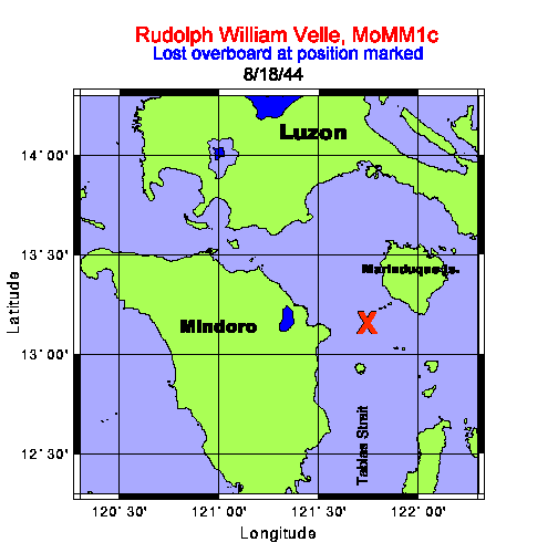 1520(H): One depth charge. "Although the wartime report stated only "One depth charge", there were more explosions. At the time I wrote the report I had assumed that all the explosions were depth charges dropped from the PT boat. We found out from Velle after the war however that shortly after we submerged an aircraft also arrived and dropped a couple of bombs or depth charges. To protect himself against the shock of the explosions Velle said he did his best to keep his belly out of the water, and yet at the same time he was afraid of being seen by the plane. Fortunately He wasn't injured nor seen and the plane left, leaving the PT boat searching for us, with Velle starting his long, long swim. (Former C.O.) 1630(H): Lost contact and came up for a look. All clear. "A popular acronym used early in the war by G.I.s - SNAFU (Situation Normal, All F---d Up) epitomizes this battle surface we had attempted. If any blame is to be assessed, it is mine as the C.O., but it is hard to accept because it was one of those times when a small thing-one tiny thing-starts a string of events that multiply and explode completely out of control of any one involved. The courage, initiative, and proper reaction of every member of the crew prevented the incident from being fatal. The patrol report I wrote at that time left a lot unsaid. Having decided to use our guns, the 4-in. and 20mm, I ordered 'battle surface-gun action', which went well. Essentially it meant mustering the deck gun crews in the conning tower under the hatch to the bridge, (lookouts in the control room as usual), then increasing speed while at the same time commencing blowing the ballast tanks, and holding the boat at periscope depth with the planes. When impossible to hold the depth any longer, the planes would be put on full rise, and the boat would pop to the surface with a good freeboard so that I, followed by the gun crews and the lookouts, could man the upper decks quickly. The guns were soon firing, but then things started to go wrong. The 20mm Oerlikons jammed and ceased fire. The first four shots of the 4-in. deck gun went way over. I saw one hit on the hillside of the Island well behind the ships. The SEA TRUCK convoy immediately turned, some toward us, (I had thought they would all turn away!) and I found we were closing range much too fast making the fire control problem worse. Also they unveiled some heavy guns I didn't know they had, (lesson-remember to look for things like that next time) and their first salvo straddled us. That was unsettling, (another lesson-even a sad little convoy like this had big guns and good gunners with them). They had our range quickly. They also had machine guns firing, and at the speed we were closing we would very quickly be within range. The situation was deteriorating fast! I decided discretion was the better part of valor, turned away, and ordered the guns crews to cease- fire and the men to clear the deck while I maneuvered the boat into a better attack position. No aircraft or surface escorts had appeared yet. I then intended to get the guns crews back and start shooting again. At that moment it hadn't dawned on me there was something wrong with the 4-in. gun sights. That is when the situation went out of control. Upon the order 'Clear the deck' one of the first of the 4-in. gun crew coming up over the front of the bridge fascia and windshield, accidentally kicked the diving alarm switch as he jumped off the bridge shelf to get to the hatch beneath leading below. I wasn't aware of the diving alarm in the confusion, but very soon saw that the vents had been opened and we were diving. It was too late to stop it. As the last 4 or 5 of us crowded under the bridge shelf to enter the hatch, I discovered the water was up to my ankles. At that moment as I looked about to make sure no one was left behind the thought hit me '(expletive) I have to be the last man down!! As the last man before me jumped into the open hatch the bridge superstructure was completely under water, with only the shelf over my head providing a brief air pocket. As I jumped in and grabbed the toggle to pull the hatch shut behind me I was literally washed into the conning tower with the rush of water pouring in. (The conning tower had a good drain to the pump room below). Robert McDonald, MoMM1/c, the auxiliary man on the manifold in the control room, told me recently that we were then passing 50 feet on the depth gauge. This was the depth that the top of the periscope shears went under! It was also the first the watch below realized Velle was missing. The people in the conning tower had the presence of mind to count us coming down, note I hadn't appeared yet, and not panic at the water pouring in and try to close the hatch too soon. I have had bad dreams at times about this, and have often wondered if I could have also made that 14 mile swim. I admire Velle for his fortitude and determination." (Former C.O.) 1852(H): Surfaced and returned to the spot we submerged hoping Velle was still in the vicinity. Nothing could be found so set course for the eastern entrance to Verde Island Passage. "As soon as the PT boat left us we came back up to periscope depth, and I made a good all around search. It was still broad daylight, and with the hornets nest we had aroused I didn't think it wise to surface until sure no aircraft were out. I did see the PT boat still searching so we remained submerged and returned to our diving position while continuing to search for Velle through the scope. When we finally surfaced-it was earlier than the time given in the report-it was still good daylight, and we covered quite a bit of ground looking for Velle. At the time I assumed he would have headed for the nearest island which was about 6 to 8 miles to the north and we searched mainly in that direction. I later found Velle had headed, sensibly, in the opposite direction for a larger more prominent island with a high mountain peak he could continue to see after dark even though it was 14 miles away." (Former C.O.) "This is the type of Sea Truck I saw in the convoy we shot at with our 4" deck gun." (Former C.O.)  (Former C.O.) "These Photos are from the publication ONI 208-J, Supplement 2, issued to and carried by each submarine to aid in identification of ships encountered. The photo following below is a PT-1 class boat and is the type that was escorting the Sea Truck convoy. The boat I saw that came after us did not have the camouflaged paint job, but was a dark gray or dull black color. These boats had sonar, and were armed with 2-18" torpedoes, two machine guns, and 2 to 6 depth charges." 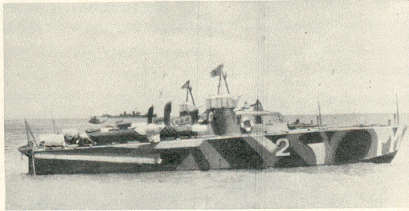 August 20, 1944 0100(H): (SC#14) (torpedo Attack #1) made contact with the SJ Radar on a group of about five ships, bearing 066°T, range 18,050 yards. The night was dark, with a clear horizon, smooth sea, and sky overcast. Position: Latitude 13-32 N, Longitude 121-26 E. "I heard the call on the 1MC 'Captain to the bridge', rolled out of bed, and headed for the control room. I had been dozing in my cabin dressed and wearing my red goggles to protect my night vision so I was ready and hoping the topside watch had some good targets we could attack." (Former C.O.) 0104(H): Commenced tracking and found they were on a westerly course heading for Verde Island Passage from the North entrance of Mompog Pass. 0113(H): Went to battle stations and headed in for an attack as they soon would enter Verde Island Passage. They appeared to be in a formation of two columns, three ships in the far and two in the near column with about five hundred yards interval between columns. I intended to come in on the port bow of the second ship in the near column. "I couldn't see them in the dark from the bridge, and I had good night vision, but radar had them clearly on the screen, and the plotting table was tracking well." (Former C.O.) 0122(H): Broke off attack as the leading ship on the port hand had dropped back abeam of the second ship and the trailing vessel was drawing forward of the port quarter of the second ship. There were apparently three escorts, one ahead, one astern, and one on the starboard bow of the convoy. 0207(H): Started in again as formation had steadied down with the two leading ships abreast, two more in line of bearing on their port quarter, and a third on the port quarter of the whole formation on course 245°T, speed 9.5 knots. Chose further one of two nearest ships as first target, bearing 000° Rel., angle on bow 64P, gyro angle 347.5, torpedo run 2100 yards, own course 340°T, speed 5 knots, and at 0215-19: Fired #4 tube. "I could dimly see the target ships, and the torpedo wakes were bright." (Former C.O.) 0215-24: Fired #5 tube. 0215-32: Fired #6 tube. Shifted to nearest ship bearing 007°Rel., angle on bow 65P, gyro angle 355°, torpedo run 1500 yards and at 0215-52: Fired #1 tube. 0216-01: Fired #2 tube. 0216-08: Fired #3 tube. Went ahead full with right full rudder, when picked up third ship range 2,000 yards, on the port quarter of second target. He looked a fair size so stopped and steadied on course 160°T and got a set up for a stern tube shot. Target bearing 175 Rel, angle on bow 90P, gyro 162.5°, torpedo run 3,000 yards, and at 0219-02: Fired #7 tube. "They didn't appear to react to the bright wakes, but the escorts did." (Former C.O.) 0219-12: Fired #8 tube. 0219-22: Fired #9 tube. 0221(H): Went ahead full and opened out to pull ahead and attempt to get in again while making a reload. All torpedoes appeared to run normally, and their course could be followed almost 4,000 yards by the brilliant phosphorescence of the water. The second three torpedoes were clearly seen to pass under their target although the depth set was four feet. The targets could not be identified, but from what was seen while firing, and later discussions, I do not believe now they were over 1000 tons. While we were firing I had seen a ship on the starboard quarter of the convoy pull to the right and at 0238(H): He commenced dropping depth charges astern of us, range 2,900 yards by radar. (Former C.O.) "In Sketch A, and Sketch A, part 2, following this note, I have shown the disposition of the convoy and escorts to scale indicating the times and relative positions and times of the GUNNEL and the two columns of ships. The period from firing the first torpedo #4,(0215-19), until the last torpedo crossed the track of the furthest ship at 0220-22 is shown. The initial position of the first targets, ship A in the far column, and ship D in the near column are shaded solid black, as is the GUNNEL, and their subsequent positions at the time the torpedoes crossed their track are shown dotted. The first torpedo of the three fired at ship A, (number 4 tube), and ship D, (number 1 tube), were each aimed at the center of the target ship upon firing, with the following two torpedoes offset to the right and to the left of center as they were fired. The torpedo tracks are shown in blue. At the time we believed the three torpedoes fired at ship D from tubes 1,2,and 3 passed under their target, however reconstructing this now from the data available indicates torpedo 1 and 2 could have missed astern. The torpedo from number 3 tube was seen to run straight and hot, (all six torpedoes in fact were seen and heard by sonar to run straight and hot) and the plot shows number 3, 4, and 6 must have run under their targets. Had they been running at the depth set, they would have hit and detonated. No target ship appeared to have seen the torpedo wakes and changed course." 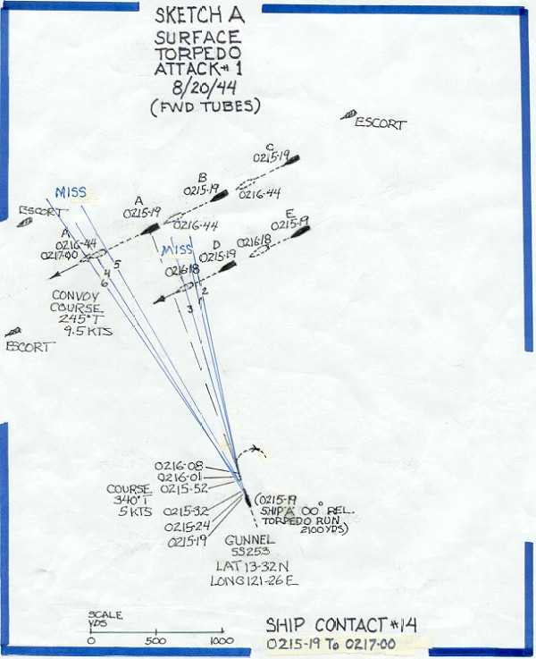 (Former C.O. remarks continued)." "The same was true of the three torpedoes fired aft at ship C from tubes 7, 8, and 9. The plot shows the target ship and the three torpedoes each intersect in time at the target position on the track, and at the least two of the three torpedoes should have hit. No geyser of water, or explosion was seen or heard. The only explanation for the failure to hit and detonate is that they ran deeper than the four feet set. As I mentioned previously in these comments, we were deactivating the magnetic feature, and setting the torpedoes to run at the shallowest depth permitted by the existing sea state, in order to be sure of a contact hit on the hull of the target. These failures, when one was certain the fire control settings were correct, and one could see the phosphorescent torpedo wake appear to pass right under the target, were very discouraging. Years later we learned the German subs had the exact same problem with their torpedoes early in their use. In this dark night, although the lookouts and I could visually see these ships at the time of firing,, details could not be distinguished and on reflection now they most probably were small coastal freighters or wooden sea trucks. Even so their draft loaded should have been more than the four feet set on the torpedoes. These misses were hard to accept. Small or not I wanted to sink them!" 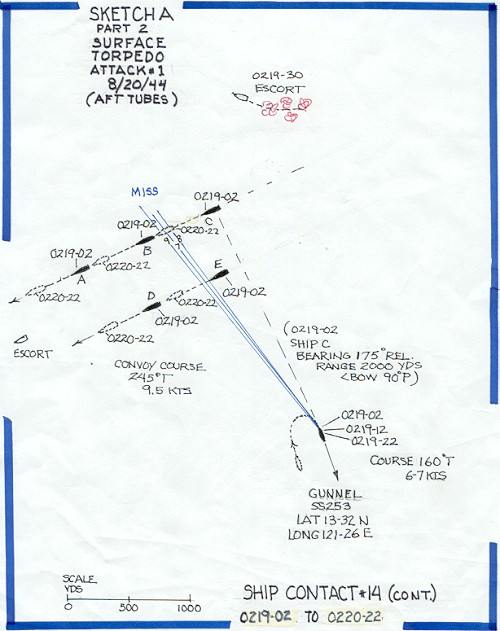 0250(H): (SC#15) Picked up an escort on our starboard bow bearing 017°T, range 2,400 yards closing so changed course to 160°T and went ahead flank. At the same time radar reported the vessel who had dropped the depth charges bearing 046°T range still 2,900 yards and now closing. Eased over to 180°T to put the two ships on each quarter and continued flank speed. 0312(H): Finally lost both contacts astern. The escort on our port quarter was the most persistent for he closed to 2,000 yards and stayed right with us at 18.5 knots for about 20 minutes, then dropped slowly back to 4,000 yards and at about 0312 apparently reversed course as his range suddenly opened rapidly and was lost at about 8,000 yards. Our wake was shining like a bright light astern during this chase. (Former C.O.) "I had put all four main engines on line and ordered flank speed. That meant the maneuvering room controllers were to load the engines to 100% power at 100% rated engine speed. This would produce the maximum speed the boat was capable of making. I also had the Control Room start the low-pressure blowers to empty the ballast tanks of residual water so we would ride higher and hopefully make a few more propeller RPM. The sea was slight so we rode well, but we couldn't seem to pull away. The escort was obviously doing his best also and the radar operator, Neil Carter, RT1/c continued to sing out 'range 2,000 yards - steady.' The engineering officer Lt. Walt Robinson, concerned about the engines, went aft to check on things. I also had the helmsman use as little rudder as possible to hold his course, but the range hung right on at 2,000 yards. The enemy was staying right with us. He apparently couldn't use his gun to fire dead ahead, and we had no gun aft to use. I considered firing a torpedo or two from the after tubes, but held off as I was uncertain how they would act leaving the tubes in the disturbed water at the speed we were making. I didn't want a premature detonation or a circular run to occur. We couldn't dive for he would have been right on top of us before we could get deep enough for safety. After about twenty tense minutes of this I called the maneuvering room and asked them if they could make more speed. , As I remember it was Peter Paskiewich, MoMM1/c, a k a Ski who came back on the inter-com speaker saying 'Captain, do you want chasing speed or being chased speed?' I told him 'being chased speed!' and a few minutes later Lt.(jg) Jim Thornton watching the radar screen below called out with excitement in his voice: 'the range is opening - its OPENING-Two thousand and FIVE yards!' I remember the sound of cheering from below! The Japanese skipper happily got discouraged as the range gradually opened, and then, finally rapidly opened as they gave up the chase and turned away. It was much later before I found out how the engine room gang got that extra speed. It seems Winston "Von" Von Brethorst MoMM1/c and his oiler Sal Bommerito, MoMM3/c took it upon themselves to hold their thumbs on the engine speed governors and let the engines overspeed. The governors were set to limit engine speed to a little over 700 RPM. They got above that, but nothing broke and we won the race." 0357(H): (SC#16) Picked up a patrol vessel on our port bow bearing 059°T range 4,600 yards. Altered course to the left again and tracked him at 13 knots until we lost him astern at 6,500 yards at 0410(H). 0425(H): (SC#17) Picked up another patrol vessel bearing 120°T range 7,000 yards. Tracked this one at almost 18 knots while we maneuvered to avoid. He closed to 6,400 yards and we finally lost him astern at 7,7,00 yards at 0440(H). 0449(H): Submerged as it was becoming light. Set a course to take us to the southern entrance to MomPog Pass, passing to the south of the DOS HERMANAS Islands. 0708(H): (SC#18) Sighted six sea trucks bearing 352°T range about 7,000 yards on course of about 090°T. 0745(H): (AC#20) Sighted a type Pete aircraft bearing 340°T range 5 miles. He was really looking for us for he was flying a sine curve at about 500 feet and his base course was right overhead. Position Latitude 13-00 N, Longitude 121-41 E. Eased down to 150 feet. 0809(H): (SC#19) Sound picked up screws bearing 300°T, 156 RPM. Took a look and found a type PC-1 patrol boat moving up our starboard side on a parallel course. He passed out of sight ahead. They certainly had our 0800 position figured out. 0845(H): (SC#20) sighted two more sea trucks bearing 308°T on a course of about 095°T. 1005(H): (SC#21). Picked up same PC-1 patrol boat by sound and periscope heading back from the vicinity of MAESTRE DE CAMPO Island crossing our bow from starboard to port, range 3000 yards. He disappeared on a course of 010 T in the direction of MARINDUQUE Island. 1200(H): Position: Latitude 13-00 N, Longitude 121-47 E. 1237(H): (SC#22). Sighted a small motor sampan bearing 121 T range about 6000 yards which soon disappeared. 1550(H): (AC#21). Sighted an unidentified aircraft bearing 291 T range about three miles which disappeared in a cloudbank. 1848(H): Surfaced and proceeded for patrol station in vicinity southern entrance MOMPOG PASS. 2045(H): (SC#23). Picked up what appeared to be a patrol boat bearing 041 T range 11,400 yards. At first he tracked at 12 kts on a course of about 190 T, and then when the range had closed to about 9200 yards he stopped and lay to. We opened to the west to get around him and finally lost him at 11,000 yards bearing 051 T, still stopped. Position: Latitude 13-13 N, Longitude 122-25 E. August 21, 1944 0455(H): Submerged for day's patrol on a line four miles off GUINDUGANAN POINT. 0555(H): (C#24). Sighted one sea truck bearing 117 T, range 4500 yards on a course of 000 T. Position: Latitude 12-58 N, Longitude 122-53 E. 1700(H): Found another leaking liner seal ring on #2 main engine. Decided to hold engine for emergency use and work on it after submerging in the morning. 1857(H): Surfaced and commenced patrol covering the southern approaches to MOMPOG PASS. August 22, 1944 0509(H): Submerged for patrol in same position as yesterday. 1352(H): (SC#25) (Torpedo Attack #2) Sighted masts and smoke bearing 090°T range 12,000 yards of what turned out to be two lone AK's of about 1,000 gross tons each. Manned battle stations and commenced approach. Position: Latitude 12-54 N, Longitude 122-51 E. Illustrations and Photo of typical Coastal Freighters (steel Sea Trucks)   1450(H): With #2 periscope out of commission due to a short circuit in the hoist motor and being worked on, tried to make an observation and found the other periscope wouldn't raise. Continued approach by sound. 1457(H): Completed emergency repairs on #2 periscope hoist motor finally and found we were in a perfect position on a ninety port track and a 2,200 yard torpedo run on the farthest target. The two ships were in a line of bearing about 500 yards apart with the bow of the nearer one just overlapping the stern of the far one. Even though they were small decided to shoot as I didn't see how I could miss. Torpedoes were set on three feet and both targets draft must have been at least six or seven feet as they were loaded. With the far target on course 236°T, speed 9.5 knots, range 2250 yards, own course 020°T, speed 3 knots, at 1458-57: Fired #1 tube. 1459-07: Fired #2 tube. 1459-14: Fired #3 tube. 1459-24: Fired #4 tube. 1459-33: Fired #5 tube. 1459-43: Fired #6 tube. The torpedoes were spread by periscope along the length of the two targets. No. 1 torpedo was seen to run erratically to the left. The remainder of the torpedoes ran hot straight and normal. I am certain #3 and #4 ran under the far ship and #5 and #6 ran under both ships. Neither ship changed course until after the torpedoes passed under, then they commenced zigging wildly. 1515(H): Set a course of 270°T to clear this area and spent remained of the day placing both periscopes back in commission. 1856(H): Surfaced and headed for the entrance to Tablas Strait. We have raised so much fuss around here in the last few days without accomplishing anything that I decided to try a new spot. #2 engine still out of commission (leaking engine liner seal). A second leaky liner seal ring was found during the day making two units that had to be pulled. This was the last spare and any more bad leaks mean the loss of one engine. (Former C.O.) "Sketch B following illustrates torpedo attack #2, and it is constructed to the same scale and fashion as Sketch A which illustrated torpedo attack #1. The first torpedo in this attack was fired from number 1 tube. It went off course to the left, but the remaining five ran hot, straight, and normal. There were only two targets, no escorts, and it should have been an easy job to sink them both in the same salvo. With the nearest ship overlapping the far target, and a torpedo run of 2200 yards, (1800 yards to the nearest ship), I chose to spread the torpedoes by aiming each shot with the periscope. I spaced the aiming points from aft forward along the lengths of the two ships. The torpedo tracks drawn to scale using the data given in the patrol report confirm what I saw at the time and suggest that #3 and #4 also ran under the nearest ship. As with attack #1, there was no plume of water or explosion seen or heard as the torpedo tracks intersected the targets. A thorough check of the remaining torpedoes didn't disclose any problems. It was frustrating because three feet was the limiting depth that could be set and be fairly sure the torpedo would not broach and run on the surface. "These Coastal Freighters, or Steel Sea Trucks had a draft (light) of at least 6.5 feet, and a draft (loaded) of 13 to 16.5 feet, so the misses can only be explained by the torpedoes running much deeper than set." " 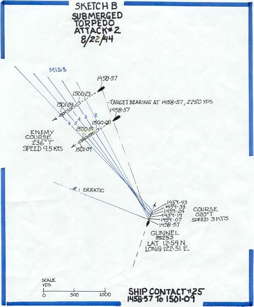 August 23, 1944 0130(H): #2 Main engine back in commission. 1847(H): Surfaced and headed south to send message about losing Velle over the side. August 24, 1944 0135(H): Unable to raise VIX0, so sent message #3 blind. We later found it was received. 0504(H): Submerged for days patrol on a line three to four miles off SOJOTON POINT, NEGROS ISLAND. 1853(H): Surfaced and commenced patrol of PANAY GULF and entrances to GUIMARAS STRAIT. "At our two engine cruising speed we would reach the northern tip of PANAY Island by morning light. From previous experience in these waters, and from reading other patrol reports, the best chance of finding enemy shipping was off focal points such as PUCIO POINT and NASO POINT at each end of PANAY. I also had decided to move on a little further and try the area in the SULU SEA between PANAY and NEGROS Islands." (Former C.O.) 0513(H): Submerged for the day off PUCIO POINT, PANAY. 0530(H): Another bad leaking liner seal ring found in #2 main engine. Engine to be used in emergency only. August 25, 1944 0518(H): Submerged for days patrol off SOJOTON POINT. 0900(H): Lost power operation of bow planes. "The heat and humidity in the boat affected not only the crew, about 20 bad cases of heat rash had developed, but also the electrical equipment. Insulation on the wires in the electrical boxes was getting brittle and cracking shorting out the circuits. Weather remained the same as when we passed through here heading north on the 15th. The sea was choppy, with moderate surface winds, and the sky overcast." (Former C.O.) 1232(H): (AC#22) Sighted two aircraft identified as type TOPSY, bearing 178°T, two miles, on a course of 020°T. Position: Latitude 10-03 N, Longitude 122-29 E. 1857(H): Surfaced with one main engine out of commission due to a broken head bolt, two other engines out due to a total of seven minor leaking liner seal rings and one bad leak per engine, no power operation of the bow planes either rigging or tilting due to broken wires in the torpedo room panel and control room switch box, a peculiar noise had developed in #3 main motor and the air conditioning still out since 15 August. Set a course to seaward while trying to repair all the casualties and started a charge plus propulsion on our one remaining engine and the auxiliary. Thank God these boats have four main engines. 2100(H): As a last straw we lost steering in the conning tower for the rest of the night due to forcing too much grease in the hull packing and cocking the gland. "We had a leak into the control room where the shaft from the steering control in the conning tower entered the pressure hull, and earlier in the evening after we surfaced I had allowed a volunteer to crawl under the decking to tighten the packing. I remember being very upset when later on the steering control froze for it meant having to send someone up again to correct the mistake. We were all getting a little jumpy with the heat and the problems. Upon reflection I realized the machinist mate who had climbed under the deck in the dark of night, in these waters, to make that repair was risking his neck and under pressure and I shouldn't have jumped on him as I did. I got him aside later and apologized. At a crew reunion I attended not long before writing these notes, he mentioned this to me, and that he had appreciated my doing that. Looking back now to those days the men manning these boats had to be truly courageous and they deserve tremendous credit and admiration. They were volunteers willing to live sealed up in confined quarters, not knowing what would happen next, many never seeing light of day until returning to port at end of patrol. Once that hatch was closed over their head upon leaving port, they were provided very little information on projected movements and assigned areas (for their protection should they ever become POW's). Despite all this they carried out their duties cheerfully with elan and skill, and with trust in their shipmates that working together they would always return safely." (Former C.O.) August 26, 1944 0518(H): Submerged off SOJOTON POINT for day's patrol. During the night repaired one main engine and steering, still working on remainder of casualties. 1901(H): Surfaced for patrol of Panay Gulf. Everything in commission except #2 main engine and the air conditioning plant. #2 engine could be used in emergency by refilling with water and keeping the purifier on the sump to take as much water as possible out of the oil. #3 main engine still had three minor leaks but that didn't interfere with normal operation. Source of noise in #3 main motor still undetermined. (Former C.O.) "This was probably the low point for everybody on this patrol. I remember it certainly was for me. Everything seemed to be breaking down and hard to repair. We had been without air-conditioning since 0530 the morning of August 9 just after having crossed the Equator off CELEBES ISLAND. These waters are always warm and the air is hot above, so submerged or surfaced, the interior of the boat remained humid and hot. In the evening, when we could surface, there was always a battery charge required taking hours to complete adding a lot of heat in the boat .This offset any relatively cool night air that could be drawn in. At times immediately after surfacing we could close the main induction valve and take air for the engines through the boat via the conning tower hatch, but that was only a brief respite. Showerbaths were out of the question because the battery had priority and required almost all the water we could make. We were all miserable, clothes damp with sweat, no relief in sight. To top it off we weren't getting any hits in our attacks we were able to make, and the Japanese air and surface patrols were effectively keeping us from making attacks on every contact." August 27, 1944 0515(H): Submerged for days patrol on a line three miles off NASO POINT, PANAY Island to cover route between CUYO EAST PASS and ILOILO or GUIMARAS STRAIT. 1832(H): Surfaced and commenced patrol of PANAY GULF. I intended to head for the western coast of MINDANAO the following night but at 2200(H): Received orders to proceed to the SOUTH CHINA SEA. "Each day or night on the surface, we listened to the "FOX Schedule", a general broadcast of all the encoded messages addressed to the boats on patrol sent at fixed times and repeated for several days. The radioman on watch copied each broadcast as it became available, and each boat then decoded the messages addressed to them. No answer was required unless specifically directed in the message. We could keep radio silence and yet remain informed. The Germans required their boats to answer messages, and their transmitted answer homed in on by the British and Americans accounted for many of their losses. The message we received this night instructed us to join up with the USS GUITTARRO as part of a wolf pack for a few days. The C.O. was a friend of mine, LCDR. E.D. Haskins and he had departed on patrol shortly before we left. Ed's previous patrol had been successful. They sank a Frigate, and a good-sized cargo vessel. I hoped joining him would change our luck, and it was an area more productive of targets." (Former C.O.) August 28, 1944 0725(H): Submerged for passage of APO EAST PASS, MINDORO STRAIT, with AMBULONG ISLAND bearing 345°T, 16 miles. 1907(H): Surfaced and set course for rendezvous. "A note here for those readers who might be interested but do not have a chart or map to follow; otherwise skip it. APO EAST PASS was the right hand passage of the two available routes through MINDORO STRAITS between the southern tip of LUZON Island south of MANILA BAY and MINDORO Island north of the large Island of PALAWAN. This route had the deepest water and was a major shipping route between the Sulu Sea and the South China Sea. It was least likely to be mined we hoped. The entrance in the SULU SEA was narrow, requiring passing about two miles off AMBULONG Island, (its navigational light darkened) and passage required passing close to several other islands. Fortunately we could cover that part submerged surfacing at dark and continuing through the more open spaces on the surface out to the deep ocean area. As far as I can ascertain we never lost a boat here." (Former C.O.) August 29, 1944 0158(H): Picked up what appeared to be SJ radar interference ahead, so headed towards. 0225(H): Established voice communications with the GUITARRO. 0245(H): (SC#26) SJ radar contact bearing 145°T range 7,000 yards. We held the range at about 8,000 yards and finally succeeded in establishing mutual identification by communication on the SJ radar at 0315(H). (Former C.O.) "Not long before this date, most of our submarines had been equipped with a voice radio, and we had a simple four letter code we could use for fairly secure communication with other submarines at short ranges. This had allowed the development of two to three boat wolfpacks, which was very profitable. In addition we had been able for some time to use the SJ (surface search) radar equipped with a telegraph key to communicate with other boats out to the range of the radar. As we all used the same frequency, we were always alerted (assuming our set was tuned properly and putting out the proper energy) to the presence of a friend by the interference pattern appearing on the radar scope, and we could talk together by keying the set. This could be picked up by the Japanese of course, so we only used it briefly for identification, and relied upon the old signal light carried to the bridge for passing information back and forth. The lantern was hooded, hand held, and so one had to get close on the surface for proper use." 0323)H): Closed range to visual signal distance and received instructions for joint patrol for next two days. "There wasn't time for much talk via the signal light, but Haskins told me they had sunk a ship on the 10th, 21st, and the 27th. There was another convoy expected, and we agreed on a plan for joint action should they come our way. In the end nothing showed up. After the war I learned a little more of what had happened to the GUITARRO on the 21st. Haskins had been part of a wolf pack with the HARDER, LCmdr. Sam Dealey, HADDO, LCmdr. Chester Nimitz, and RATON, LCmdr Mike Shea. On August 20, the RAY, LCmdr Bill Kinsella had observed a large convoy of 12 ships and 5 or more escorts enter PALUAN BAY, near CAPE CALAVITE to anchor for the night before proceeding north. He made contact with Dealey who headed the wolf pack and a plan was devised in which they all could confront the convoy when they sortied. An epic battle ensued on the 21st. The submarines started their attacks as the convoy departed about 0430(H) and continued all morning. Five ships were sunk for 28,242 tons. The escorts dropped over 100 depth charges. At one point HADDO had three escorts on one side and two on the other all of them about 3000 yards away dropping depth charges as fast as they could. Chester Nimitz reported the noise was so loud in the conning tower he had to shout to be heard. Sadly Sam Dealey and his magnificent crew were lost in this action. Dealey had devised the down the throat shot and held the record for sinking four destroyers and two frigates by this tactic. Harder survived the initial phases of the battle but was subsequently lost that day at a time and place unknown." (Former C.O.) 0527(H): Submerged for day's patrol covering shipping routes between PALAWAN PASSAGE and MANILA. 1200(H): Position: Latitude 13-10 N, Longitude 119-24 E. 1853(H): Surfaced and set course for initial point for the nights joint patrol. August 30, 1944 0528(H): Submerged for days stationary patrol at assigned position. 1200(H): Position: Latitude 12-52.5 N, Longitude 120-16 E. 1904(H): Surfaced with joint patrol concluded as other submarine departed area. Headed north in order to be off CAPE CALAVITE in the morning. It was a clear bright moonlit night but due to the proximity of land decided to keep the SD radar secured and depend on lookouts and the SJ radar for aircraft detection. "Not using the SD was a bad decision. A lesson learned. I had assumed the Japanese were routinely scanning to pick up our aircraft search radar signal when we used it, which like radio was all directional and I reasoned turning on our SD this close to shore would alert them to our presence and they would send out aircraft. So I thought at that time! Obviously they didn't need our radar signal to alert them. They had planes out looking and were finding us anyway. This was a cat and mouse game with an awfully big cat. What followed shortly after midnight was an experience no one forgot. The crew are still talking about it at every reunion, and we all feel we are still here to talk about it through the alertness of one man and the instant correct team reactions of the watch standers at the time." (Former C.O.) August 31, 1944 0032(H): (AC#23) An extra man on the bridge for air sighted an unidentified aircraft about 500 feet overhead and coming from astern. Position: Latitude 13-25 N, Longitude 119-45 E. OOD made a quick turn to the right and then submerged. "It so happened, that I was that extra man on the bridge and spotted that plane at about 500 feet up. The moon's reflection on the windows of the plane and the exhaust from the four motors could be seen clearly. The plane was a flying boat I recognized as a four-motored Mavis bomber. I yelled at Mr. Stevens, the OD and pointed up at the plane. He turned and saw it and ordered 'Right full rudder, DIVE!' Larry De Souza, a Fire Controlman was also an extra man topside on the cigarette deck working on an electrical instrument there, and he really had to hustle to get down the hatch in time." (Jim "Ike" Eisenhower) "I had been making some adjustments to the TBT (target bearing transmitter) on the after part of the Conning Tower Bridge. Two crewmen, Jim Eisenhower and Swede Larson had been given permission to come topside for some fresh air or a smoke. I had just finished buttoning up the TBT when Jim Eisenhower, one of the two extra men, jumped to his feet and pointing up yelled 'there's a plane up there, right up there's a plane!' Mr. Stevens, the OD immediately cleared the bridge, sounded the diving alarm, and we and the lookouts scrambled for the hatch to get below." (Larry De Souza) 0035(H): One very close bomb or depth charge as we passed 100 feet going down. No major damage was done although many sea valves were jarred open, a deck plate was blown off topside, and cork knocked loose. Power operation was lost temporarily on the bow planes and tubes were knocked loose in the SJ radar putting it out of commission. "I had gone below to my cabin in the forward battery to get some rest not long before. I had just dozed off when I was awakened by the feel of the boat heeling over with full rudder, the sudden quiet of the engines shutting down and the 'auoohga auoohga' of the diving alarm. I headed for the Control Room at a run, laboring uphill pulling on anything I could grab as the boat took a steep down angle in the dive, and pulled myself through the hatch into the Control Room to find everything going well. We were leveling off and Buck Stevens, the OOD now acting as Diving Officer was ordering periscope depth, when a tremendous explosion suddenly bounced and shook us as a bomb went off right over us. The chief on the manifold had been questioning Ike Eisenhower as to what he had seen, and in the sudden silence I heard a voice say 'well I guess he did see one!' The lights went out of course as circuit breakers opened, as did all powered operation, but the planesmen quickly shifted to hand and got the boat leveled off. Larry De Souza, who in 1944 was a Fire Controlman 2nd Class, writing to me about this incident in a letter in March 2000, told me that he had seen Jim "Ike" Eisenhower again in 1993 in good health. Larry said in his letter, 'I remember one of the guys saying that (at the reunion) no one seems to remember Ike. (He had only made three runs on the GUNNEL before transferring to the LAPON at the end of the 6th patrol). My reply was "You don't remember Ike! If it weren't for Ike, there probably wouldn't be a GUNNEL reunion tonight. He was the extra man on the bridge that saw the plane that night and saved the boat'". (O'Neil, former C.O.) Damage wasn't fatal and could be repaired. We later found we lost some decking and pieces of super-structure top side, and cork lining the hull interior was knocked loose in places. Sea valves were knocked open, but they could all be closed again and Power operation of the diving planes was soon restored. Once we got the SJ radar working we surfaced. The rest of the night was uneventful, and we remained on the surface until morning twilight of the 1st. then submerged for the day again." 0328(H): SJ radar back in commission, all clear on the SD radar so surfaced and topped off the battery charge. "We were lucky damage wasn't fatal. The bomb detonated as our depth gauge indicated 100 feet, the depth of the keel under the control room. With the steep angle of the dive, the superstructure deck aft over the engine rooms at that moment was only about 20 feet below the surface at the point the bomb entered the water. The pressure hull aft including interior pipe lines and valves subject to full sea pressure fortunately held, and the crew quickly closed valves and circuit breakers knocked open throughout the boat. Leaks were stopped, and lights and power operation of the diving planes and other machinery was soon restored. Later we found the cork lining the hull interior was knocked loose and missing in places. The OOD, Buck Stevens, and the two lookouts from the bridge that took over the bow and stern planes upon reaching the control room had handled the dive well, (one of our fastest), and hadn't lost control. Once we got the SJ radar working we surfaced. After surfacing, we found we had lost some wooden decking aft, and pieces of metal superstructure were gone. When the engines were started we discovered the patch we had placed over the hole in #4 muffler back on 7 August had been blown off, and there was now a second larger hole in the same muffler that was beyond our repair capabilities. It made that engine sound like a hot rod exhaust with a cut out. Unfortunately it was one of the good engines, so for the remainder of the patrol we held our breath every time we had to not so silently pass close to land on the surface at night sounding louder than a 100-car freight train laboring uphill in a mountain pass. The noise reverberated from every hillside. From this point in time also we began having trouble with the SD radar caused by water getting inside the antenna mast. We found the porcelain water tight insulator at the top of the mast had been cracked by the force of the explosion and now leaked." (Former C.O.) 0508(H): Submerged for days patrol and headed towards CAPE CALAVITE. 1910(H): Surfaced with another bright moonlight night ahead. Using the SD radar this time by keying it. 2321(H): (AC#24) Two lookouts sighted an unidentified aircraft bearing 040 T, range 8 miles, which disappeared immediately. Position: Latitude 13-29 N, Longitude 119-51 E. Nothing sighted. 2356(H): (AC#25) Two lookouts sighted an unidentified aircraft bearing 040 T, range between 2 and 3 miles, heading towards us so submerged and went deep. Position: Latitude 13-26 N, Longitude 119-51 E. Neither radar picked this one up although it was very close. September 1, 1944 0210(H): Surfaced, all clear by radar. 0211(H): (AC#26) One lookout sighted an unidentified aircraft ahead crossing our bow from port to starboard, range about six miles, and flying low. No Radar contact. 0219(H): (AC#27) Lookouts sighted an unidentified aircraft bearing 200°T, very close with a 35° position angle and heading towards us so submerged and went deep. Again neither radar picked it up. I had thought contact number 26 above was imagination but believe now it was the same plane. They apparently were keeping below our SD radar and possibly were homing its signal although it was being keyed. Decided to wait for moonset to surface this time as they had us behind the eight ball. 0406(H): Surfaced and topped off battery charge. 0506(H): Submerged for day's patrol covering routes between MANILA and PALAWAN PASSAGE. "I was delighted for this opportunity to patrol this area. I felt there was a greater chance of encountering larger ships than we had been finding so far in our original area of the SIBUYAN and SULU SEA. We were on the main trade route between Japan and the MALAY BARRIER for convoys routed through PALAWAN PASSAGE. The bad news was that we could not enter the DANGEROUS GROUNDS to the southwest because of many uncharted shoals and reefs and we were advised to stay out of PALAWAN PASSAGE because of the unknown navigational hazards and probable mines. There were no charts available to us for either area. This meant we would not have much maneuvering room to make attacks on ships encountered, particularly those heading south." (Former C.O.) 1901(H): Surfaced and headed towards PALAWAN PASSAGE. With our inability to detect these planes and a bright full moon for the next few nights decided to get further from the coast so that should we be held down all night at least we could surface at daylight and get in a battery charge. September 2, 1944 0037(H): (AC#28) Picked up a target on the SJ radar PPI screen, range about 4,000 yards closing and moving very rapidly from our starboard quarter up our starboard side. Submerged and went deep. This contact may have been a badly overworked imagination after the last two nights but it definitely wasn't a rainsquall and if it was a fish it was making a good 80 knots and giving a good pip on the radar. 0247(H): Surfaced and headed for northern entrance to PALAWAN PASSAGE for day's surface patrol. 1848(H): Submerged for a trim. 1900(H): Surfaced. "During the next three days, September 3, 4, and 5 we remained in an area roughly between Latitude 12-10 N and 13-00 N and longitude 119-12 E and 119-50 E. We remained on the surface again on the 3rd, making the usual trim dive about 7PM. On the night of the 4th we closed the coast of BUSANGA Island and at morning light submerged and remained submerged during the day. Nothing but fish noises heard on sonar. We saw one aircraft (AC#29) early that morning after we submerged but he got no closer than 8 miles. There was another aircraft contact (AC#30) at 0412(H) the morning of the 5th flying low and closing our position, so we submerged and remained so for the rest of that day. Nothing else of interest was heard or seen. The sky was clearing and the winds decreasing with smooth seas." (Former C.O.) September 6, 1944 0353(H): (AC#31) Sighted an unidentified aircraft bearing 310°T, on a course of about 270°T and closing. Submerged to avoid detection. 0612(H): Surfaced. 0633(H): (SC#27) Sighted smoke from many ships bearing 310°T range about 40,000 yards. Commenced closing in order to determine course and speed. Position: Latitude 12-50 N, Longitude 119-09 E. 0643(H): (AC#32) Sighted an aircraft, identified as a type Lucy, bearing 070°T on our starboard quarter, distance about 10 miles and closing. Submerged to avoid detection. "I still remember this day. The sky was clear and the visibility was excellent. This was what I was hoping for and I was excited seeing the smoke of the ships on the horizon. The sea was smooth and almost glassy. I hated to have to dive for the aircraft, but I figured if we were going to get in to this convoy we couldn't afford to be seen this soon. There was no evidence that the Japanese air patrols had seen us yet. Preliminary tracking data indicated the convoy was heading for PALAWAN PASSAGE, about 80 miles south, and I figured if we could get a little time on the surface, we had a chance to outrun them to the entrance, dive in front and get a shot at them. They appeared to be good-sized ships and they probably were well escorted. I hoped that if there were other aircraft they would stay on the opposite side, and this one we saw wouldn't range too far ahead. It turned out otherwise." (Former C.O.) 0736(H): With no aircraft insight, surfaced and commenced end around on the convoy which appeared to be on a course of about 200°T. The sea was like glass and it was a bright clear day. 0745(H): (AC#33) Sighted what appeared to be the same aircraft now circling over the convoy bearing 106°T. After about ten minutes the plane appeared to be closing us so submerged to avoid detection. A flash of light from the plane at this time was first thought to be a recognition challenge but after submerging I realized it was only the reflection of the sun off his windscreen. Continued observations of the smoke and the aircraft until the plane drew out of sight. "Watching the plane I was startled to see him executing some neat snap rolls and slow rolls, dives and zooms about fifty feet over the convoy. If he was that bored I decided to surface and get going again." (Former C.O.) 0947(H): Surfaced and continued end around. 0957(H): (AC#34) Sighted the same aircraft as before circling over the convoy. He appeared to be patrolling about 10 to 15 miles on the port flank of the convoy and up to ten miles ahead which effectively prevented us from closing and seeing anything more than smoke. Position: Latitude 12-38 N, Longitude 119-01 E. I attempted to stay far enough away so the plane would not sight us at the same time keeping the smoke in sight and working into a position ahead of the convoy which was heading for Palawan Passage. The plane was in sight the remainder of the morning. I believe a second plane guarded the starboard flank but could not be seen from our position. 1305(H): The convoy appeared to have changed base course to the left for the plane in it's sweeps was drawing closer. Still nothing but smoke in sight. I was trying to squeeze between the convoy and the northeastern edge of Palawan Passage in order to make a submerged approach before dark. 1320(H): The plane appeared to be closing us, so when the range was reduced to about six miles submerged and attempted to close the smoke on a normal approach course going high speed between looks. 1448(H): Two aircraft in sight. They either were relieving the watch or both were patrolling the same side now. Their eastward sweep took them very close to us. 1630(H): Abandoned approach and decided to try again after dark. It looked like I would have time to get ahead again before moonrise at 2130. Also if it didn't get light too soon I would have a chance for a surface attack. The bearing of the smoke continued to draw forward. "This was taking a lot out of the battery." (Former C.O.) 1902(H): Surfaced and continued chase. "Got a battery charge started to be prepared for later use." (Former C.O.) 1944(H): Picked up nearest ships of convoy by SJ radar bearing 225°T range 22,000 yards. Position: Latitude 11-31 N, Longitude 118-25 E. Commenced tracking and end around. The convoy base course was now 165°T and they had speeded up to 11-12 knots. Continued around the eastern side for there wasn't a chance to make it around the other side before moonrise. I hoped I could be ahead before becoming silhouetted in the moon or caught in the shoal water bordering Palawan Island. "The situation still looked hopeful." (Former C.O.) 2030(H): Too light for surface attack already so continued on staying outside 20,000 yards in order to get ahead and make a submerged approach in moonlight. "The Japanese escort forces were on their toes." (Former C.O.) 2130(H): Moonrise and still about 10 miles to go to get on the convoys track. The SD radar took this time to get out of commissions so we kept on and held our breath. 2157(H): (AC#35) Sighted an unidentified aircraft overhead just as it dropped a brilliant white parachute flare. Submerged hoping it was just a recognition signal to the convoy and we weren't sighted. Continued closing and at 2235(H): Sighted smoke again bearing 320°T range about 10,000 yards. Went to battle stations and took normal approach course at high speed. Position: Latitude 10-56 N, Longitude 118-27 E. The convoy consisted of four medium AKs and three large AKs, one of which might have been a large tanker. Their base couse was now about 200°T. Only two escorts were visible, a Chidori and a small PC boat. We were holding our own and had closed the range to about 8,000 yards on the nearest ship with angle on the bow 85 port when at 2354(H): Made an observation and found a type PC-1 escort vessel with an angle on the bow of zero and range 3,000 yards. The convoy was back out to 10-12,000 yards with an angle on the bow of 140 Port. The PC boat circled us at about 1,000 yards and then continued snooping around and listening so we eased deep to shake him off. If he had only a deep enough draft I could have gotten a good shot at him with our MK 14's. I could see three men walking down his deck aft as he went by. Apparently he had seen our periscope in the moonlight or else we had been seen by the plane, although I had been careful in my looks. (Former C.O.) "Reading this entry in my patrol report again (this is August 1999) brings back the memory of that day and night. W e had been chasing that convoy 16 hours. The sea under the bright moonlight was clear, and through the periscope I could see the escort clearly at over 1000 or more yards. He didn't seem to have sonar contact on us but he knew we were there, although he obviously wasn't sure enough to make an attack. I took short looks with very little scope out of the water, but even so I had a real good look at him as he circled around us. The radius of his turn about us remained the same until he was heading again in the direction of the convoy, at which time he steadied on that course and left us in his wake. The convoy was getting further away all the time and in this moonlight they weren't going to let us get on the surface again that night. They won this round, but we would be back again. I identified him as a PC-1 class submarine chaser. Below is a copy of the pictures of this class as shown in ONI 208-J, the recognition book we carried. The distinctive features, the shape of the bridge structure, funnel with high mounted lifeboat in davits, and the rounded stern were unmistakable. He looked big viewed through the periscope, but seeing some of the crew strolling along the deck as he moved around us showed him to be smaller than the GUNNEL. They don't look dangerous in the photo, but they did good work in the war and were responsible for some of our losses. He was probably the same class of escort that chased us after our unsuccessful attack the night of August 20."  September 7, 1944 0128(H): Lost the escort vessel and nothing more in sight by periscope. I believe the convoy entered the reefs at Latitude 10-50° N. Longitude 118-30 E and continued south in the shoal water close along the west coast of PALAWAN Island which was the direction they were headed when last seen. As our SD radar was still out and this area was well patrolled at night by aircraft decided to remain submerged till daylight. 0822(H): Surfaced for a battery charge. Proceeding north back into area. That was certainly a disappointment to lose out on the only real torpedo targets seen the whole patrol. I think we would have gotten in if the first plane hadn't forced us down at 0400 that morning. 1154(H): Could not raise VIX0 again so transmitted message #4. 1213(H): (AC#36). Sighted an unidentified aircraft, which disappeared below the horizon on a southerly course bearing 075 T. 1630(H): SD radar back in commission. September 8, 1944 0141(H): (AC#37) Lookouts sighted an unidentified aircraft bearing 240 T, coming from astern and closing. Submerged to avoid detection. Position: Latitude 12-50 N, Longitude 120-07 E. 0248(H): Surfaced. 0529(H): Submerged for day's patrol in northern entrance MINDORO STRAITS. "Our patrol time was up and Jim Zurcher, the Navigator had the charts broken out to set course for home. Our route would be back through APO EAST PASS, then southward in the SULU SEA to NASO POINT, PANAY. From there we would head due south to ZAMBOANGA, and then along the SULU ARCHIPILAGO to PEARL BANK and SUBUTU PASSAGE off TAWITAWI retracing the route we took coming north at the beginning of the patrol. When clear of SIBUTU Island, we would tale a new route heading southward remaining close to BORNEO and enter MAKASSAR STRAIT, passing close to CAPE MANGKALIHAT, then exiting into the FLORES SEA. We would leave enemy controlled waters passing through the barrier via LOMBOK STRAIT, thence SSW to Freemantle with a brief stop in EXMOUTH GULF, AUSTRALIA to leave excess fuel, or take on a little extra if needed to get us home." (Former C.O.) 1859(H): Surfaced and commenced transit of APO EAST PASSAGE departing from area in accordance with patrol instructions. 1916(H): (SC#28) Made contact by SJ radar on what appeared to be two small vessels bearing 087 T range 1400 yds. During the next hour they drew rapidly ahead and were lost at a range of 6,000 yds. Bearing 190 T. They apparently were patrol craft as they were making about 16 kts, and were quite small. One could be seen ahead for a short while before radar lost contact 2130(H): Completed passage APO EAST PASS and set course for NASO POINT, PANAY via CUYO EAST PASS. At this point the chase is over. Gunnel was not able to get into a position where an attack was possible. September 9, 1944 0530(H): Submerged for day's patrol off NASO POINT, PANAY. 1047(H): (SC#29) Sighted two sea trucks bearing 112 T, range about 5 miles, proceeding north close along the coast. Position: Latitude 10-27 N, Longitude 121-49 E. "They were the small wooden sea trucks, too small for torpedoes." (Former C.O.) 1229(H): (SC#30) Sighted one SCS-1 class special duty sub-chaser bearing 079 T range about 4 miles proceeding north along the coast. Position: Latitude 10-25 N, Longitude 121-51 E. "Thinking about this today I am sorry now I had not made an effort during the patrol to get clear of things, and try to fix the gun sights. It would have been a makeshift job, as we didn't have the equipment, but it might have been possible to use the gun in this case. This was a type of target made for gunfire. As to torpedoes, we were too far off the track for this contact, and he was going too fast for us to reach a torpedo firing position submerged. Also he was too small to be sure the torpedo would not run under, and too dangerous to get him stirred up should we miss. He had a lot of help around here he could call on for assistance. On sober reflection I decided he wasn't worth it and regretfully let him go his way." (Former C.O.) 1841(H): Surfaced and set course for BLANCA POINT, MINDANAO. 1925(H): Sent message number 5 stating our intention of spending a couple of extra days waiting for traffic in the SULU SEA instead of proceeding homeward. "Editors note: The original patrol report entries are sparse and incomplete for the period from September 10 through September 15. The events covering these days departing station and heading home have been summarized in the following paragraphs by the former C.O. Capt. O'Neil" "September 10 through the rest of the week were not productive of targets. During this time the GUNNEL moved slowly southward, lingering at traffic crossroads, hoping to find a juicy target or targets that could be attacked. I wanted very badly to get something before we left these waters. My orders said, "depart area" but I wasn't going to hurry. We spent this day on submerged patrol off BLANCA POINT, MINDANAO Island and that night covered the traffic routes between CEBU and ZAMBOANGA." "September 11. Back off BLANCA POINT for the day again, surfacing at 1741(H). Since nothing had been found here for two days in this area, we headed back north that night for NASO POINT, PANAY. At 2350(H) we made visual and radar contact (SC#31) on a large ship 20,000 yards to the west steaming on a northerly course, but upon closing for a better look we were disappointed to find it was a properly marked and lighted hospital ship. Position Latitude 090-50 N, Longitude 122-00E, It was probably loaded with raw rubber and other war goods but we had to let it go on its way." "September 12, (SC#32) At 28 minutes past midnight we picked up radar interference and radar contact at 13,500 yards, which we identified as a U.S. submarine. We made an attempt to exchange identification but before this was certain our radar couldn't identify ourselves; I didn't want one of our boats shooting at us thinking we were a Japanese patrol. We submerged for an hour at 0219(H) to fix the SJ radar, and when it was back in service we surfaced and remaining on the surface set course for SIBUTU PASSAGE. At 1245(H) and again at 1610(H) we were forced to dive briefly to avoid detection by aircraft (AC#38) and (AC#39) both of which continued on out of sight. Strangely we picked these up with our SD radar on this clear sunshiny day, when it hadn't been able to make contact during the last two weeks of moonlit nights. At 1940(H) as it became dark we commenced transit of the passage west to east between DOC CAN Island and PEARL BANK, and at 2310(H) commenced transit of SIBUTU PASSAGE with BONGAO PEAK and SIBUTU HILL in clear view. As usual I pictured a hundred binoculars watching us and guns being readied, but except for the flickering lights here and there all was quiet (except our engines)." "September 13. We emerged at 0055(H) into the CELEBESE SEA, completing an uneventful passage and set a course to the southwest to cover traffic lanes between MAKASSAR STRAIT and TARAKAN. Our course took us close to MARATEGA Island and thence southeast to enter MAKASSAR STRAIT close to CAPE MANGKALIHAT. At 0942(H), number 3 main engine developed a bad water leak which left us with only two good engines, one of which had the two large holes in the muffler. We would have to use the noisy one the rest of the way and keep #3 in reserve. At 0944(H) and again at 1110(H) we had to dive to avoid aircraft (AC#40) and (AC#41). The lookouts sighted the first at 9 miles closing, and radar picked up the second at 7 miles. At 2242(H) we passed CAPE MANGKALIHAT abeam to starboard at 10 miles then headed southwestward along the coast." "September 14. Submerged at 0526(H) and spent the day patrolling in the vicinity of BIRAH BIRAHAN Island in the Straits, about 40 miles off the coast of BORNEO. Upon surfacing that evening we headed south-southeast cutting across the strait making for CAPE WILLIAM, SULAWESI. Nothing was seen or heard during that day or night." "September 15. At 0215(H) (SC#33) we picked up radar interference bearing 210 T, and exchanged recognition signals and calls by SJ radar. It was a U.S. submarine heading north. Position Latitude 02-03 S, Longitude 118-34 E. We wished him good hunting. The day was spent patrolling submerged off CAPE WILLIAM. We surfaced at 1843(H) and continued South. At 2255(H) (SC#34) made radar contact bearing 296 T, range 13,000 yards position Latitude 04-06 S, Longitude 117-53 E. Happy day! This appeared to be a convoy of ships. Stationed the tracking party, turned to normal approach course and commenced tracking to solve course and speed." (Former C.O.) September 16, 1944 0026(H): Went to battle stations and made ready torpedo tubes. The contact had developed into a group of four ships on base course 105°T, zigging between 85°T and 125°T at a speed of 8 knots, apparently heading for MAKASSAR CITY. Went ahead full on four engines and commenced approach intending to fire at 2,000 yards on the port beam of the central ship. We had them lined up against the only good patch of horizon in the area, the sky being overcast. 0100(H): With the range 2,500 yards identified the four targets from the bridge as a group of sea trucks. Turned away and secured the tubes. I had previously thought something was peculiar because the maximum range to which we could follow all four of them was 15,000 yards and a medium sized ship can be easily held at 24,000 yards with our SJ. Having already wasted 15 torpedoes on shallow draft spit kits I didn't intend to throw away anymore. Our four inch gun was out of commission since we last fired it so we left them and continued south. "That was our last chance to get something this patrol. I made up my mind the next run was going to be better. I started serious discussions in the wardroom on the way home with a lot of thought on how to keep the machinery and electronics in better health; and how to be sure the torpedoes ran better. I determined also to try to get a more productive area assigned to work in". (Former C.O.) 0615(H): Sighted SIBIRU ISLAND on the starboard bow, range about 12 miles. Set course for LOMBOK STRAIT. 0945(H): (AC#42) Aircraft contact on the SD radar at 8 miles which commenced to open slowly as we submerged. Position: Latitude 05-39 S, Longitude 117-00 E. 1013(H): Surfaced. 1840(H): Picked up LOMBOK and BALI Islands by SJ radar range 100,000 yards on either bow. 2155(H): Put all four main engines on the line and commenced transit LOMBOK STRAIT favoring the BALI side of the channel. "We had been warned there was a possibility the Japanese had or would place guns on the LOMBOK Island shore. In my experience in previous patrols in other submarines passing through LOMBOK STRAIT we had never had evidence of weapons installed on shore. It was quiet this night (except for us). Not long after this the Japanese started shooting with a battery of 6-in. guns at our submarines they sighted passing through here. They had no success with the possible exception, during the last month of the war, of the USS BULLHEAD the last American submarine we lost. They were last seen and heard of in or near this strait and might have been sunk by gunfire, although an air attack is more likely. The high mountain of BALI blanked out the SD radar and prevented early warning of aircraft. The strait was deep water throughout its length and about 15 miles wide at its narrowest, and due to strong currents usually required passage on the surface. Happily that made it difficult if not impossible to mine. I never experienced problems but I never was able to relax and enjoy the exotic scenery." (Former C.O.) September 17, 1944 0000(H): Completed transit of LOMBOK STRAIT, set course for the bombing restriction lane. No patrols encountered. "We resumed two engine cruising speed for the rest of the journey." (Former C.O.) 0613(H): Submerged for a trim. 0632(H): Surfaced. 0942(H): Sent message number 6. September 18, 1944 0130(H): (SC#35) Picked up radar interference bearing 190 T from an SJ Radar on a friendly submarine. Position: Latitude 15-15 S, Longitude 114-35 E. 0202(H): Completed exchange of recognition signals by keying the radar, but unable to exchange calls as the signal faded out, still ahead. 0326(H): (SC#36) Sighted a green flare bearing 190 T range about 15 miles and at the same time picked up SJ radar interference and what appeared to be a challenge by radar on the same bearing. Answered with one green flare. 0335(H): Succeeded in answering challenge and exchanging calls by radar with a U.S. Submarine bound north position Latitude 15-38 N, Longitude 114-25 E. "It would have been an interesting note for history to identify these boats heading north but for security reasons they couldn't be identified in the patrol report at the time it was written, and unfortunately I don't remember now who they were. (Former C.O.) 1200(H): Position Latitude 17-31 S, Longitude 113-47 E September 19, 1944 0908)H): Sighted land through the high periscope and identified as VLAMING HEAD, Northwest Cape, Australia. 1120(H): Commenced entry EXMOUTH GULF, Australia. 1319(H):Moored port side to fuel barge, Exmouth Gulf, and found he was slowly but surely sinking. At the time of our arrival the crew were sitting patiently on deck measuring the distance they would have to swim for their pumps were as usual broken down. We rigged a hose from our trim line suction in the forward battery and commenced taking a suction on his pump room with our drain pump, as I didn't see any way we could get home unless we could keep him afloat and take fuel on. Then we ordered the shore station to send out hose and gasoline for their pump and by 1500(H) the extra pump was rigged and the water level was going down. 1858(H): The barge crew finally had their fuel pump out of water and in commission so commenced taking on fuel. 2146(H): Underway, having received about 5,000 gallons diesel fuel. As we cast off our lines I heard one of the barge crew state the water level was rising again. 2340(H): Departed Exmouth Gulf, set course in bombing restriction lane for Fremantle, W.A. September 20, 1944 0053(H): (SC#38) Picked up radar interference bearing 270°T. Exchanged calls and identification signals with another U.S. submarine proceeding into Exmouth Gulf for fuel. Notified him of the difficulties he would encounter, but as our fuel was just enough to get us back and I felt sure he would arrive before the barge sank did not return to offer help with fuel. 0235(H): Sent message number 7. September 22, 1944 Arrived Fremantle, W.A. completing this vessel's sixth war patrol. Epilogue The captain made several notations in his patrol report under the heading "Health and Habitability". The food carried was good and of sufficient variety. It was a very pleasant experience for the commanding officer after subsisting on Australian beef for a year in this area to once again eat American meat supplied by the recently arrived tender. Not much can be said for the preparation of the food as three unimaginative cooks and the Navy cookbook is a bad combination for even the hardest working commissary officers. Habitability was very poor and the lack of air conditioning was keenly felt because the area assigned required many days of submerged running. One does not realize the blessing in disguise afforded by air conditioning until a patrol is made without it in these waters. It takes a lot out of a person to spend day after day gasping for breath and dripping with sweat. Under the "Personnel" section he had these comments: This is the third consecutive patrol made by this vessel in which the results were negligible, yet the morale of the crew is excellent and all hands are ready to get out and get going again to make up for lost time. Both officers and crew performed their duty in an excellent manner. It is deeply regretted that Rudolph William Velle, MoMM1c, USN, was lost over the side; but as he was uninjured, a good swimmer and close to land, it is felt that his chances of survival are excellent. It is the hope of all hands that he escaped detection by the Japs and assuming they are thinly spread in this area his chances of reaching friendly hands is believed good. It turns out that Velle did make it to land by swimming approximately 14 miles. He made contact with friendly natives and was eventually picked up by another American submarine and returned to active duty.  Patrol Statistics Miles steamed = 11,227 Fuel Oil expended = 140,780 Patrol Length = 55 Days Torpedoes Remaining = 9 Fuel Remaining = 4,300 Provisions (days) = 10 Endurance Factor Ending Patrol = Fuel and operational order. Of the 55 days spent at sea, she spent 30 days submerged !  Adams, Lavelle, Lopatin, Glave, "Moe" Relaxing on the beach at the Royal Hawaiian Hotel in Hawaii after another successful patrol.  Mac, Moe and Mr. Leidholdt  |
|
|
|
 |
| Tags |
| screenshots |
|
|


 Linear Mode

