Helmsman 
Join Date: Apr 2007
Location: 500 Ft. Below the Surface
Posts: 105
Downloads: 883
Uploads: 0
|
 The GUNNEL part 2
 1520(H): One depth charge.
"Although the wartime report stated only "One depth charge", there were more explosions. At the time I wrote the report I had assumed that all the explosions were depth charges dropped from the PT boat. We found out from Velle after the war however that shortly after we submerged an aircraft also arrived and dropped a couple of bombs or depth charges. To protect himself against the shock of the explosions Velle said he did his best to keep his belly out of the water, and yet at the same time he was afraid of being seen by the plane. Fortunately He wasn't injured nor seen and the plane left, leaving the PT boat searching for us, with Velle starting his long, long swim. (Former C.O.)
1630(H): Lost contact and came up for a look. All clear.
"A popular acronym used early in the war by G.I.s - SNAFU (Situation Normal, All F---d Up) epitomizes this battle surface we had attempted. If any blame is to be assessed, it is mine as the C.O., but it is hard to accept because it was one of those times when a small thing-one tiny thing-starts a string of events that multiply and explode completely out of control of any one involved. The courage, initiative, and proper reaction of every member of the crew prevented the incident from being fatal. The patrol report I wrote at that time left a lot unsaid. Having decided to use our guns, the 4-in. and 20mm, I ordered 'battle surface-gun action', which went well. Essentially it meant mustering the deck gun crews in the conning tower under the hatch to the bridge, (lookouts in the control room as usual), then increasing speed while at the same time commencing blowing the ballast tanks, and holding the boat at periscope depth with the planes. When impossible to hold the depth any longer, the planes would be put on full rise, and the boat would pop to the surface with a good freeboard so that I, followed by the gun crews and the lookouts, could man the upper decks quickly. The guns were soon firing, but then things started to go wrong. The 20mm Oerlikons jammed and ceased fire. The first four shots of the 4-in. deck gun went way over. I saw one hit on the hillside of the Island well behind the ships. The SEA TRUCK convoy immediately turned, some toward us, (I had thought they would all turn away!) and I found we were closing range much too fast making the fire control problem worse. Also they unveiled some heavy guns I didn't know they had, (lesson-remember to look for things like that next time) and their first salvo straddled us. That was unsettling, (another lesson-even a sad little convoy like this had big guns and good gunners with them). They had our range quickly. They also had machine guns firing, and at the speed we were closing we would very quickly be within range. The situation was deteriorating fast! I decided discretion was the better part of valor, turned away, and ordered the guns crews to cease- fire and the men to clear the deck while I maneuvered the boat into a better attack position. No aircraft or surface escorts had appeared yet. I then intended to get the guns crews back and start shooting again. At that moment it hadn't dawned on me there was something wrong with the 4-in. gun sights. That is when the situation went out of control. Upon the order 'Clear the deck' one of the first of the 4-in. gun crew coming up over the front of the bridge fascia and windshield, accidentally kicked the diving alarm switch as he jumped off the bridge shelf to get to the hatch beneath leading below. I wasn't aware of the diving alarm in the confusion, but very soon saw that the vents had been opened and we were diving. It was too late to stop it. As the last 4 or 5 of us crowded under the bridge shelf to enter the hatch, I discovered the water was up to my ankles. At that moment as I looked about to make sure no one was left behind the thought hit me '(expletive) I have to be the last man down!! As the last man before me jumped into the open hatch the bridge superstructure was completely under water, with only the shelf over my head providing a brief air pocket. As I jumped in and grabbed the toggle to pull the hatch shut behind me I was literally washed into the conning tower with the rush of water pouring in. (The conning tower had a good drain to the pump room below). Robert McDonald, MoMM1/c, the auxiliary man on the manifold in the control room, told me recently that we were then passing 50 feet on the depth gauge. This was the depth that the top of the periscope shears went under! It was also the first the watch below realized Velle was missing. The people in the conning tower had the presence of mind to count us coming down, note I hadn't appeared yet, and not panic at the water pouring in and try to close the hatch too soon. I have had bad dreams at times about this, and have often wondered if I could have also made that 14 mile swim. I admire Velle for his fortitude and determination." (Former C.O.)
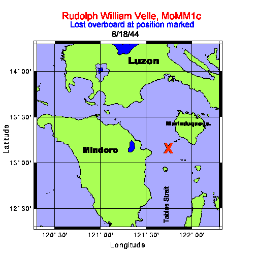
1852(H): Surfaced and returned to the spot we submerged hoping Velle was still in the vicinity. Nothing could be found so set course for the eastern entrance to Verde Island Passage.
"As soon as the PT boat left us we came back up to periscope depth, and I made a good all around search. It was still broad daylight, and with the hornets nest we had aroused I didn't think it wise to surface until sure no aircraft were out. I did see the PT boat still searching so we remained submerged and returned to our diving position while continuing to search for Velle through the scope. When we finally surfaced-it was earlier than the time given in the report-it was still good daylight, and we covered quite a bit of ground looking for Velle. At the time I assumed he would have headed for the nearest island which was about 6 to 8 miles to the north and we searched mainly in that direction. I later found Velle had headed, sensibly, in the opposite direction for a larger more prominent island with a high mountain peak he could continue to see after dark even though it was 14 miles away." (Former C.O.)
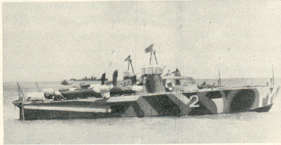
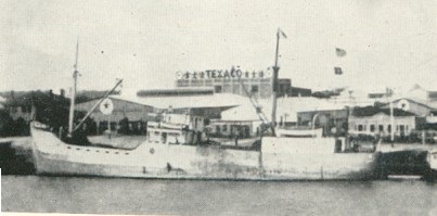
"This is the type of Sea Truck I saw in the convoy we shot at with our 4" deck gun." (Former C.O.)
1520(H): One depth charge.
"Although the wartime report stated only "One depth charge", there were more explosions. At the time I wrote the report I had assumed that all the explosions were depth charges dropped from the PT boat. We found out from Velle after the war however that shortly after we submerged an aircraft also arrived and dropped a couple of bombs or depth charges. To protect himself against the shock of the explosions Velle said he did his best to keep his belly out of the water, and yet at the same time he was afraid of being seen by the plane. Fortunately He wasn't injured nor seen and the plane left, leaving the PT boat searching for us, with Velle starting his long, long swim. (Former C.O.)
1630(H): Lost contact and came up for a look. All clear.
"A popular acronym used early in the war by G.I.s - SNAFU (Situation Normal, All F---d Up) epitomizes this battle surface we had attempted. If any blame is to be assessed, it is mine as the C.O., but it is hard to accept because it was one of those times when a small thing-one tiny thing-starts a string of events that multiply and explode completely out of control of any one involved. The courage, initiative, and proper reaction of every member of the crew prevented the incident from being fatal. The patrol report I wrote at that time left a lot unsaid. Having decided to use our guns, the 4-in. and 20mm, I ordered 'battle surface-gun action', which went well. Essentially it meant mustering the deck gun crews in the conning tower under the hatch to the bridge, (lookouts in the control room as usual), then increasing speed while at the same time commencing blowing the ballast tanks, and holding the boat at periscope depth with the planes. When impossible to hold the depth any longer, the planes would be put on full rise, and the boat would pop to the surface with a good freeboard so that I, followed by the gun crews and the lookouts, could man the upper decks quickly. The guns were soon firing, but then things started to go wrong. The 20mm Oerlikons jammed and ceased fire. The first four shots of the 4-in. deck gun went way over. I saw one hit on the hillside of the Island well behind the ships. The SEA TRUCK convoy immediately turned, some toward us, (I had thought they would all turn away!) and I found we were closing range much too fast making the fire control problem worse. Also they unveiled some heavy guns I didn't know they had, (lesson-remember to look for things like that next time) and their first salvo straddled us. That was unsettling, (another lesson-even a sad little convoy like this had big guns and good gunners with them). They had our range quickly. They also had machine guns firing, and at the speed we were closing we would very quickly be within range. The situation was deteriorating fast! I decided discretion was the better part of valor, turned away, and ordered the guns crews to cease- fire and the men to clear the deck while I maneuvered the boat into a better attack position. No aircraft or surface escorts had appeared yet. I then intended to get the guns crews back and start shooting again. At that moment it hadn't dawned on me there was something wrong with the 4-in. gun sights. That is when the situation went out of control. Upon the order 'Clear the deck' one of the first of the 4-in. gun crew coming up over the front of the bridge fascia and windshield, accidentally kicked the diving alarm switch as he jumped off the bridge shelf to get to the hatch beneath leading below. I wasn't aware of the diving alarm in the confusion, but very soon saw that the vents had been opened and we were diving. It was too late to stop it. As the last 4 or 5 of us crowded under the bridge shelf to enter the hatch, I discovered the water was up to my ankles. At that moment as I looked about to make sure no one was left behind the thought hit me '(expletive) I have to be the last man down!! As the last man before me jumped into the open hatch the bridge superstructure was completely under water, with only the shelf over my head providing a brief air pocket. As I jumped in and grabbed the toggle to pull the hatch shut behind me I was literally washed into the conning tower with the rush of water pouring in. (The conning tower had a good drain to the pump room below). Robert McDonald, MoMM1/c, the auxiliary man on the manifold in the control room, told me recently that we were then passing 50 feet on the depth gauge. This was the depth that the top of the periscope shears went under! It was also the first the watch below realized Velle was missing. The people in the conning tower had the presence of mind to count us coming down, note I hadn't appeared yet, and not panic at the water pouring in and try to close the hatch too soon. I have had bad dreams at times about this, and have often wondered if I could have also made that 14 mile swim. I admire Velle for his fortitude and determination." (Former C.O.)
1852(H): Surfaced and returned to the spot we submerged hoping Velle was still in the vicinity. Nothing could be found so set course for the eastern entrance to Verde Island Passage.
"As soon as the PT boat left us we came back up to periscope depth, and I made a good all around search. It was still broad daylight, and with the hornets nest we had aroused I didn't think it wise to surface until sure no aircraft were out. I did see the PT boat still searching so we remained submerged and returned to our diving position while continuing to search for Velle through the scope. When we finally surfaced-it was earlier than the time given in the report-it was still good daylight, and we covered quite a bit of ground looking for Velle. At the time I assumed he would have headed for the nearest island which was about 6 to 8 miles to the north and we searched mainly in that direction. I later found Velle had headed, sensibly, in the opposite direction for a larger more prominent island with a high mountain peak he could continue to see after dark even though it was 14 miles away." (Former C.O.)
"This is the type of Sea Truck I saw in the convoy we shot at with our 4" deck gun." (Former C.O.)
 (Former C.O.) "These Photos are from the publication ONI 208-J, Supplement 2, issued to and carried by each submarine to aid in identification of ships encountered. The photo following below is a PT-1 class boat and is the type that was escorting the Sea Truck convoy. The boat I saw that came after us did not have the camouflaged paint job, but was a dark gray or dull black color. These boats had sonar, and were armed with 2-18" torpedoes, two machine guns, and 2 to 6 depth charges."
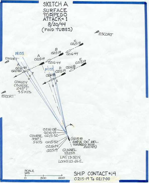
 August 20, 1944 0100(H): (SC#14) (torpedo Attack #1) made contact with the SJ Radar on a group of about five ships, bearing 066°T, range 18,050 yards. The night was dark, with a clear horizon, smooth sea, and sky overcast. Position: Latitude 13-32 N, Longitude 121-26 E.
"I heard the call on the 1MC 'Captain to the bridge', rolled out of bed, and headed for the control room. I had been dozing in my cabin dressed and wearing my red goggles to protect my night vision so I was ready and hoping the topside watch had some good targets we could attack." (Former C.O.)
0104(H): Commenced tracking and found they were on a westerly course heading for Verde Island Passage from the North entrance of Mompog Pass.
0113(H): Went to battle stations and headed in for an attack as they soon would enter Verde Island Passage. They appeared to be in a formation of two columns, three ships in the far and two in the near column with about five hundred yards interval between columns. I intended to come in on the port bow of the second ship in the near column.
"I couldn't see them in the dark from the bridge, and I had good night vision, but radar had them clearly on the screen, and the plotting table was tracking well." (Former C.O.)
0122(H): Broke off attack as the leading ship on the port hand had dropped back abeam of the second ship and the trailing vessel was drawing forward of the port quarter of the second ship. There were apparently three escorts, one ahead, one astern, and one on the starboard bow of the convoy.
0207(H): Started in again as formation had steadied down with the two leading ships abreast, two more in line of bearing on their port quarter, and a third on the port quarter of the whole formation on course 245°T, speed 9.5 knots. Chose further one of two nearest ships as first target, bearing 000° Rel., angle on bow 64P, gyro angle 347.5, torpedo run 2100 yards, own course 340°T, speed 5 knots, and at
0215-19: Fired #4 tube. "I could dimly see the target ships, and the torpedo wakes were bright." (Former C.O.)
0215-24: Fired #5 tube.
0215-32: Fired #6 tube. Shifted to nearest ship bearing 007°Rel., angle on bow 65P, gyro angle 355°, torpedo run 1500 yards and at
0215-52: Fired #1 tube.
0216-01: Fired #2 tube.
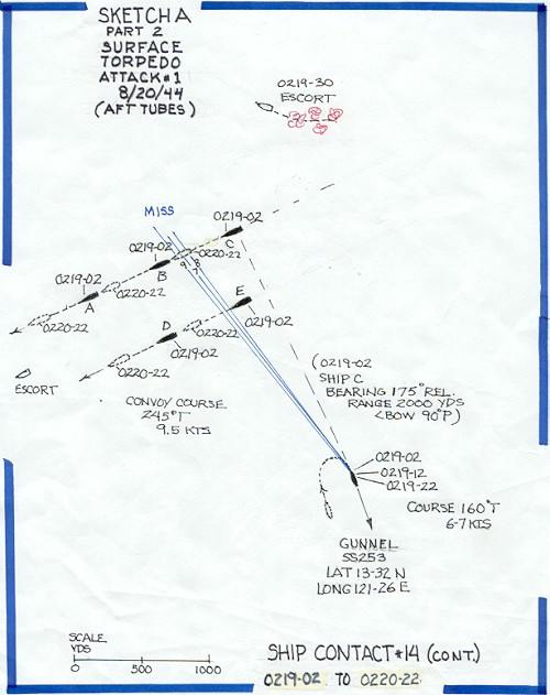
0216-08: Fired #3 tube. Went ahead full with right full rudder, when picked up third ship range 2,000 yards, on the port quarter of second target. He looked a fair size so stopped and steadied on course 160°T and got a set up for a stern tube shot. Target bearing 175 Rel, angle on bow 90P, gyro 162.5°, torpedo run 3,000 yards, and at
0219-02: Fired #7 tube. "They didn't appear to react to the bright wakes, but the escorts did." (Former C.O.)
0219-12: Fired #8 tube.
0219-22: Fired #9 tube.
0221(H): Went ahead full and opened out to pull ahead and attempt to get in again while making a reload. All torpedoes appeared to run normally, and their course could be followed almost 4,000 yards by the brilliant phosphorescence of the water. The second three torpedoes were clearly seen to pass under their target although the depth set was four feet. The targets could not be identified, but from what was seen while firing, and later discussions, I do not believe now they were over 1000 tons. While we were firing I had seen a ship on the starboard quarter of the convoy pull to the right and at
0238(H): He commenced dropping depth charges astern of us, range 2,900 yards by radar.
(Former C.O.) "In Sketch A, and Sketch A, part 2, following this note, I have shown the disposition of the convoy and escorts to scale indicating the times and relative positions and times of the GUNNEL and the two columns of ships. The period from firing the first torpedo #4,(0215-19), until the last torpedo crossed the track of the furthest ship at 0220-22 is shown. The initial position of the first targets, ship A in the far column, and ship D in the near column are shaded solid black, as is the GUNNEL, and their subsequent positions at the time the torpedoes crossed their track are shown dotted. The first torpedo of the three fired at ship A, (number 4 tube), and ship D, (number 1 tube), were each aimed at the center of the target ship upon firing, with the following two torpedoes offset to the right and to the left of center as they were fired. The torpedo tracks are shown in blue. At the time we believed the three torpedoes fired at ship D from tubes 1,2,and 3 passed under their target, however reconstructing this now from the data available indicates torpedo 1 and 2 could have missed astern. The torpedo from number 3 tube was seen to run straight and hot, (all six torpedoes in fact were seen and heard by sonar to run straight and hot) and the plot shows number 3, 4, and 6 must have run under their targets. Had they been running at the depth set, they would have hit and detonated. No target ship appeared to have seen the torpedo wakes and changed course."
August 20, 1944 0100(H): (SC#14) (torpedo Attack #1) made contact with the SJ Radar on a group of about five ships, bearing 066°T, range 18,050 yards. The night was dark, with a clear horizon, smooth sea, and sky overcast. Position: Latitude 13-32 N, Longitude 121-26 E.
"I heard the call on the 1MC 'Captain to the bridge', rolled out of bed, and headed for the control room. I had been dozing in my cabin dressed and wearing my red goggles to protect my night vision so I was ready and hoping the topside watch had some good targets we could attack." (Former C.O.)
0104(H): Commenced tracking and found they were on a westerly course heading for Verde Island Passage from the North entrance of Mompog Pass.
0113(H): Went to battle stations and headed in for an attack as they soon would enter Verde Island Passage. They appeared to be in a formation of two columns, three ships in the far and two in the near column with about five hundred yards interval between columns. I intended to come in on the port bow of the second ship in the near column.
"I couldn't see them in the dark from the bridge, and I had good night vision, but radar had them clearly on the screen, and the plotting table was tracking well." (Former C.O.)
0122(H): Broke off attack as the leading ship on the port hand had dropped back abeam of the second ship and the trailing vessel was drawing forward of the port quarter of the second ship. There were apparently three escorts, one ahead, one astern, and one on the starboard bow of the convoy.
0207(H): Started in again as formation had steadied down with the two leading ships abreast, two more in line of bearing on their port quarter, and a third on the port quarter of the whole formation on course 245°T, speed 9.5 knots. Chose further one of two nearest ships as first target, bearing 000° Rel., angle on bow 64P, gyro angle 347.5, torpedo run 2100 yards, own course 340°T, speed 5 knots, and at
0215-19: Fired #4 tube. "I could dimly see the target ships, and the torpedo wakes were bright." (Former C.O.)
0215-24: Fired #5 tube.
0215-32: Fired #6 tube. Shifted to nearest ship bearing 007°Rel., angle on bow 65P, gyro angle 355°, torpedo run 1500 yards and at
0215-52: Fired #1 tube.
0216-01: Fired #2 tube.
0216-08: Fired #3 tube. Went ahead full with right full rudder, when picked up third ship range 2,000 yards, on the port quarter of second target. He looked a fair size so stopped and steadied on course 160°T and got a set up for a stern tube shot. Target bearing 175 Rel, angle on bow 90P, gyro 162.5°, torpedo run 3,000 yards, and at
0219-02: Fired #7 tube. "They didn't appear to react to the bright wakes, but the escorts did." (Former C.O.)
0219-12: Fired #8 tube.
0219-22: Fired #9 tube.
0221(H): Went ahead full and opened out to pull ahead and attempt to get in again while making a reload. All torpedoes appeared to run normally, and their course could be followed almost 4,000 yards by the brilliant phosphorescence of the water. The second three torpedoes were clearly seen to pass under their target although the depth set was four feet. The targets could not be identified, but from what was seen while firing, and later discussions, I do not believe now they were over 1000 tons. While we were firing I had seen a ship on the starboard quarter of the convoy pull to the right and at
0238(H): He commenced dropping depth charges astern of us, range 2,900 yards by radar.
(Former C.O.) "In Sketch A, and Sketch A, part 2, following this note, I have shown the disposition of the convoy and escorts to scale indicating the times and relative positions and times of the GUNNEL and the two columns of ships. The period from firing the first torpedo #4,(0215-19), until the last torpedo crossed the track of the furthest ship at 0220-22 is shown. The initial position of the first targets, ship A in the far column, and ship D in the near column are shaded solid black, as is the GUNNEL, and their subsequent positions at the time the torpedoes crossed their track are shown dotted. The first torpedo of the three fired at ship A, (number 4 tube), and ship D, (number 1 tube), were each aimed at the center of the target ship upon firing, with the following two torpedoes offset to the right and to the left of center as they were fired. The torpedo tracks are shown in blue. At the time we believed the three torpedoes fired at ship D from tubes 1,2,and 3 passed under their target, however reconstructing this now from the data available indicates torpedo 1 and 2 could have missed astern. The torpedo from number 3 tube was seen to run straight and hot, (all six torpedoes in fact were seen and heard by sonar to run straight and hot) and the plot shows number 3, 4, and 6 must have run under their targets. Had they been running at the depth set, they would have hit and detonated. No target ship appeared to have seen the torpedo wakes and changed course."
 (Former C.O. remarks continued)." "The same was true of the three torpedoes fired aft at ship C from tubes 7, 8, and 9. The plot shows the target ship and the three torpedoes each intersect in time at the target position on the track, and at the least two of the three torpedoes should have hit. No geyser of water, or explosion was seen or heard. The only explanation for the failure to hit and detonate is that they ran deeper than the four feet set. As I mentioned previously in these comments, we were deactivating the magnetic feature, and setting the torpedoes to run at the shallowest depth permitted by the existing sea state, in order to be sure of a contact hit on the hull of the target. These failures, when one was certain the fire control settings were correct, and one could see the phosphorescent torpedo wake appear to pass right under the target, were very discouraging. Years later we learned the German subs had the exact same problem with their torpedoes early in their use. In this dark night, although the lookouts and I could visually see these ships at the time of firing,, details could not be distinguished and on reflection now they most probably were small coastal freighters or wooden sea trucks. Even so their draft loaded should have been more than the four feet set on the torpedoes. These misses were hard to accept. Small or not I wanted to sink them!"
 0250(H): (SC#15) Picked up an escort on our starboard bow bearing 017°T, range 2,400 yards closing so changed course to 160°T and went ahead flank. At the same time radar reported the vessel who had dropped the depth charges bearing 046°T range still 2,900 yards and now closing. Eased over to 180°T to put the two ships on each quarter and continued flank speed.
0312(H): Finally lost both contacts astern. The escort on our port quarter was the most persistent for he closed to 2,000 yards and stayed right with us at 18.5 knots for about 20 minutes, then dropped slowly back to 4,000 yards and at about 0312 apparently reversed course as his range suddenly opened rapidly and was lost at about 8,000 yards. Our wake was shining like a bright light astern during this chase.
(Former C.O.) "I had put all four main engines on line and ordered flank speed. That meant the maneuvering room controllers were to load the engines to 100% power at 100% rated engine speed. This would produce the maximum speed the boat was capable of making. I also had the Control Room start the low-pressure blowers to empty the ballast tanks of residual water so we would ride higher and hopefully make a few more propeller RPM. The sea was slight so we rode well, but we couldn't seem to pull away. The escort was obviously doing his best also and the radar operator, Neil Carter, RT1/c continued to sing out 'range 2,000 yards - steady.' The engineering officer Lt. Walt Robinson, concerned about the engines, went aft to check on things. I also had the helmsman use as little rudder as possible to hold his course, but the range hung right on at 2,000 yards. The enemy was staying right with us. He apparently couldn't use his gun to fire dead ahead, and we had no gun aft to use. I considered firing a torpedo or two from the after tubes, but held off as I was uncertain how they would act leaving the tubes in the disturbed water at the speed we were making. I didn't want a premature detonation or a circular run to occur. We couldn't dive for he would have been right on top of us before we could get deep enough for safety. After about twenty tense minutes of this I called the maneuvering room and asked them if they could make more speed. , As I remember it was Peter Paskiewich, MoMM1/c, a k a Ski who came back on the inter-com speaker saying 'Captain, do you want chasing speed or being chased speed?' I told him 'being chased speed!' and a few minutes later Lt.(jg) Jim Thornton watching the radar screen below called out with excitement in his voice: 'the range is opening - its OPENING-Two thousand and FIVE yards!' I remember the sound of cheering from below! The Japanese skipper happily got discouraged as the range gradually opened, and then, finally rapidly opened as they gave up the chase and turned away. It was much later before I found out how the engine room gang got that extra speed. It seems Winston "Von" Von Brethorst MoMM1/c and his oiler Sal Bommerito, MoMM3/c took it upon themselves to hold their thumbs on the engine speed governors and let the engines overspeed. The governors were set to limit engine speed to a little over 700 RPM. They got above that, but nothing broke and we won the race."
0357(H): (SC#16) Picked up a patrol vessel on our port bow bearing 059°T range 4,600 yards. Altered course to the left again and tracked him at 13 knots until we lost him astern at 6,500 yards at 0410(H).
0425(H): (SC#17) Picked up another patrol vessel bearing 120°T range 7,000 yards. Tracked this one at almost 18 knots while we maneuvered to avoid. He closed to 6,400 yards and we finally lost him astern at 7,7,00 yards at 0440(H).
0449(H): Submerged as it was becoming light. Set a course to take us to the southern entrance to MomPog Pass, passing to the south of the DOS HERMANAS Islands.
0708(H): (SC#18) Sighted six sea trucks bearing 352°T range about 7,000 yards on course of about 090°T.
0745(H): (AC#20) Sighted a type Pete aircraft bearing 340°T range 5 miles. He was really looking for us for he was flying a sine curve at about 500 feet and his base course was right overhead. Position Latitude 13-00 N, Longitude 121-41 E. Eased down to 150 feet.
0809(H): (SC#19) Sound picked up screws bearing 300°T, 156 RPM. Took a look and found a type PC-1 patrol boat moving up our starboard side on a parallel course. He passed out of sight ahead. They certainly had our 0800 position figured out.
0845(H): (SC#20) sighted two more sea trucks bearing 308°T on a course of about 095°T.
1005(H): (SC#21). Picked up same PC-1 patrol boat by sound and periscope heading back from the vicinity of MAESTRE DE CAMPO Island crossing our bow from starboard to port, range 3000 yards. He disappeared on a course of 010 T in the direction of MARINDUQUE Island.
1200(H): Position: Latitude 13-00 N, Longitude 121-47 E.
1237(H): (SC#22). Sighted a small motor sampan bearing 121 T range about 6000 yards which soon disappeared.
1550(H): (AC#21). Sighted an unidentified aircraft bearing 291 T range about three miles which disappeared in a cloudbank.
1848(H): Surfaced and proceeded for patrol station in vicinity southern entrance MOMPOG PASS.
2045(H): (SC#23). Picked up what appeared to be a patrol boat bearing 041 T range 11,400 yards. At first he tracked at 12 kts on a course of about 190 T, and then when the range had closed to about 9200 yards he stopped and lay to. We opened to the west to get around him and finally lost him at 11,000 yards bearing 051 T, still stopped. Position: Latitude 13-13 N, Longitude 122-25 E.
August 21, 1944 0455(H): Submerged for day's patrol on a line four miles off GUINDUGANAN POINT.
0555(H): (C#24). Sighted one sea truck bearing 117 T, range 4500 yards on a course of 000 T. Position: Latitude 12-58 N, Longitude 122-53 E.
1700(H): Found another leaking liner seal ring on #2 main engine. Decided to hold engine for emergency use and work on it after submerging in the morning.
1857(H): Surfaced and commenced patrol covering the southern approaches to MOMPOG PASS.
August 22, 1944 0509(H): Submerged for patrol in same position as yesterday.
1352(H): (SC#25) (Torpedo Attack #2) Sighted masts and smoke bearing 090°T range 12,000 yards of what turned out to be two lone AK's of about 1,000 gross tons each. Manned battle stations and commenced approach. Position: Latitude 12-54 N, Longitude 122-51 E.
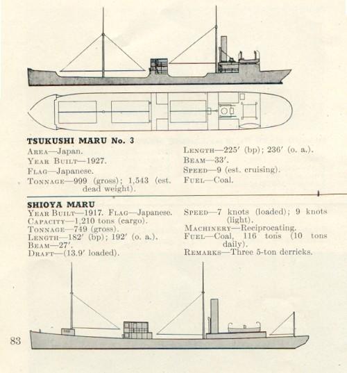
Illustrations and Photo of typical Coastal Freighters (steel Sea Trucks)
0250(H): (SC#15) Picked up an escort on our starboard bow bearing 017°T, range 2,400 yards closing so changed course to 160°T and went ahead flank. At the same time radar reported the vessel who had dropped the depth charges bearing 046°T range still 2,900 yards and now closing. Eased over to 180°T to put the two ships on each quarter and continued flank speed.
0312(H): Finally lost both contacts astern. The escort on our port quarter was the most persistent for he closed to 2,000 yards and stayed right with us at 18.5 knots for about 20 minutes, then dropped slowly back to 4,000 yards and at about 0312 apparently reversed course as his range suddenly opened rapidly and was lost at about 8,000 yards. Our wake was shining like a bright light astern during this chase.
(Former C.O.) "I had put all four main engines on line and ordered flank speed. That meant the maneuvering room controllers were to load the engines to 100% power at 100% rated engine speed. This would produce the maximum speed the boat was capable of making. I also had the Control Room start the low-pressure blowers to empty the ballast tanks of residual water so we would ride higher and hopefully make a few more propeller RPM. The sea was slight so we rode well, but we couldn't seem to pull away. The escort was obviously doing his best also and the radar operator, Neil Carter, RT1/c continued to sing out 'range 2,000 yards - steady.' The engineering officer Lt. Walt Robinson, concerned about the engines, went aft to check on things. I also had the helmsman use as little rudder as possible to hold his course, but the range hung right on at 2,000 yards. The enemy was staying right with us. He apparently couldn't use his gun to fire dead ahead, and we had no gun aft to use. I considered firing a torpedo or two from the after tubes, but held off as I was uncertain how they would act leaving the tubes in the disturbed water at the speed we were making. I didn't want a premature detonation or a circular run to occur. We couldn't dive for he would have been right on top of us before we could get deep enough for safety. After about twenty tense minutes of this I called the maneuvering room and asked them if they could make more speed. , As I remember it was Peter Paskiewich, MoMM1/c, a k a Ski who came back on the inter-com speaker saying 'Captain, do you want chasing speed or being chased speed?' I told him 'being chased speed!' and a few minutes later Lt.(jg) Jim Thornton watching the radar screen below called out with excitement in his voice: 'the range is opening - its OPENING-Two thousand and FIVE yards!' I remember the sound of cheering from below! The Japanese skipper happily got discouraged as the range gradually opened, and then, finally rapidly opened as they gave up the chase and turned away. It was much later before I found out how the engine room gang got that extra speed. It seems Winston "Von" Von Brethorst MoMM1/c and his oiler Sal Bommerito, MoMM3/c took it upon themselves to hold their thumbs on the engine speed governors and let the engines overspeed. The governors were set to limit engine speed to a little over 700 RPM. They got above that, but nothing broke and we won the race."
0357(H): (SC#16) Picked up a patrol vessel on our port bow bearing 059°T range 4,600 yards. Altered course to the left again and tracked him at 13 knots until we lost him astern at 6,500 yards at 0410(H).
0425(H): (SC#17) Picked up another patrol vessel bearing 120°T range 7,000 yards. Tracked this one at almost 18 knots while we maneuvered to avoid. He closed to 6,400 yards and we finally lost him astern at 7,7,00 yards at 0440(H).
0449(H): Submerged as it was becoming light. Set a course to take us to the southern entrance to MomPog Pass, passing to the south of the DOS HERMANAS Islands.
0708(H): (SC#18) Sighted six sea trucks bearing 352°T range about 7,000 yards on course of about 090°T.
0745(H): (AC#20) Sighted a type Pete aircraft bearing 340°T range 5 miles. He was really looking for us for he was flying a sine curve at about 500 feet and his base course was right overhead. Position Latitude 13-00 N, Longitude 121-41 E. Eased down to 150 feet.
0809(H): (SC#19) Sound picked up screws bearing 300°T, 156 RPM. Took a look and found a type PC-1 patrol boat moving up our starboard side on a parallel course. He passed out of sight ahead. They certainly had our 0800 position figured out.
0845(H): (SC#20) sighted two more sea trucks bearing 308°T on a course of about 095°T.
1005(H): (SC#21). Picked up same PC-1 patrol boat by sound and periscope heading back from the vicinity of MAESTRE DE CAMPO Island crossing our bow from starboard to port, range 3000 yards. He disappeared on a course of 010 T in the direction of MARINDUQUE Island.
1200(H): Position: Latitude 13-00 N, Longitude 121-47 E.
1237(H): (SC#22). Sighted a small motor sampan bearing 121 T range about 6000 yards which soon disappeared.
1550(H): (AC#21). Sighted an unidentified aircraft bearing 291 T range about three miles which disappeared in a cloudbank.
1848(H): Surfaced and proceeded for patrol station in vicinity southern entrance MOMPOG PASS.
2045(H): (SC#23). Picked up what appeared to be a patrol boat bearing 041 T range 11,400 yards. At first he tracked at 12 kts on a course of about 190 T, and then when the range had closed to about 9200 yards he stopped and lay to. We opened to the west to get around him and finally lost him at 11,000 yards bearing 051 T, still stopped. Position: Latitude 13-13 N, Longitude 122-25 E.
August 21, 1944 0455(H): Submerged for day's patrol on a line four miles off GUINDUGANAN POINT.
0555(H): (C#24). Sighted one sea truck bearing 117 T, range 4500 yards on a course of 000 T. Position: Latitude 12-58 N, Longitude 122-53 E.
1700(H): Found another leaking liner seal ring on #2 main engine. Decided to hold engine for emergency use and work on it after submerging in the morning.
1857(H): Surfaced and commenced patrol covering the southern approaches to MOMPOG PASS.
August 22, 1944 0509(H): Submerged for patrol in same position as yesterday.
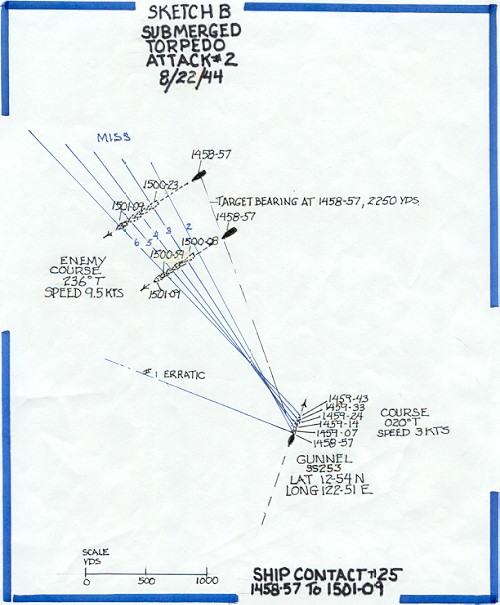
1352(H): (SC#25) (Torpedo Attack #2) Sighted masts and smoke bearing 090°T range 12,000 yards of what turned out to be two lone AK's of about 1,000 gross tons each. Manned battle stations and commenced approach. Position: Latitude 12-54 N, Longitude 122-51 E.
Illustrations and Photo of typical Coastal Freighters (steel Sea Trucks)
 1450(H): With #2 periscope out of commission due to a short circuit in the hoist motor and being worked on, tried to make an observation and found the other periscope wouldn't raise. Continued approach by sound.
1457(H): Completed emergency repairs on #2 periscope hoist motor finally and found we were in a perfect position on a ninety port track and a 2,200 yard torpedo run on the farthest target. The two ships were in a line of bearing about 500 yards apart with the bow of the nearer one just overlapping the stern of the far one. Even though they were small decided to shoot as I didn't see how I could miss. Torpedoes were set on three feet and both targets draft must have been at least six or seven feet as they were loaded. With the far target on course 236°T, speed 9.5 knots, range 2250 yards, own course 020°T, speed 3 knots, at
1458-57: Fired #1 tube.
1459-07: Fired #2 tube.
1459-14: Fired #3 tube.
1459-24: Fired #4 tube.
1459-33: Fired #5 tube.
1459-43: Fired #6 tube. The torpedoes were spread by periscope along the length of the two targets. No. 1 torpedo was seen to run erratically to the left. The remainder of the torpedoes ran hot straight and normal. I am certain #3 and #4 ran under the far ship and #5 and #6 ran under both ships. Neither ship changed course until after the torpedoes passed under, then they commenced zigging wildly.
1515(H): Set a course of 270°T to clear this area and spent remained of the day placing both periscopes back in commission.
1856(H): Surfaced and headed for the entrance to Tablas Strait. We have raised so much fuss around here in the last few days without accomplishing anything that I decided to try a new spot. #2 engine still out of commission (leaking engine liner seal). A second leaky liner seal ring was found during the day making two units that had to be pulled. This was the last spare and any more bad leaks mean the loss of one engine.
(Former C.O.) "Sketch B following illustrates torpedo attack #2, and it is constructed to the same scale and fashion as Sketch A which illustrated torpedo attack #1. The first torpedo in this attack was fired from number 1 tube. It went off course to the left, but the remaining five ran hot, straight, and normal. There were only two targets, no escorts, and it should have been an easy job to sink them both in the same salvo. With the nearest ship overlapping the far target, and a torpedo run of 2200 yards, (1800 yards to the nearest ship), I chose to spread the torpedoes by aiming each shot with the periscope. I spaced the aiming points from aft forward along the lengths of the two ships. The torpedo tracks drawn to scale using the data given in the patrol report confirm what I saw at the time and suggest that #3 and #4 also ran under the nearest ship. As with attack #1, there was no plume of water or explosion seen or heard as the torpedo tracks intersected the targets. A thorough check of the remaining torpedoes didn't disclose any problems. It was frustrating because three feet was the limiting depth that could be set and be fairly sure the torpedo would not broach and run on the surface. "These Coastal Freighters, or Steel Sea Trucks had a draft (light) of at least 6.5 feet, and a draft (loaded) of 13 to 16.5 feet, so the misses can only be explained by the torpedoes running much deeper than set." "
1450(H): With #2 periscope out of commission due to a short circuit in the hoist motor and being worked on, tried to make an observation and found the other periscope wouldn't raise. Continued approach by sound.
1457(H): Completed emergency repairs on #2 periscope hoist motor finally and found we were in a perfect position on a ninety port track and a 2,200 yard torpedo run on the farthest target. The two ships were in a line of bearing about 500 yards apart with the bow of the nearer one just overlapping the stern of the far one. Even though they were small decided to shoot as I didn't see how I could miss. Torpedoes were set on three feet and both targets draft must have been at least six or seven feet as they were loaded. With the far target on course 236°T, speed 9.5 knots, range 2250 yards, own course 020°T, speed 3 knots, at
1458-57: Fired #1 tube.
1459-07: Fired #2 tube.
1459-14: Fired #3 tube.
1459-24: Fired #4 tube.
1459-33: Fired #5 tube.
1459-43: Fired #6 tube. The torpedoes were spread by periscope along the length of the two targets. No. 1 torpedo was seen to run erratically to the left. The remainder of the torpedoes ran hot straight and normal. I am certain #3 and #4 ran under the far ship and #5 and #6 ran under both ships. Neither ship changed course until after the torpedoes passed under, then they commenced zigging wildly.
1515(H): Set a course of 270°T to clear this area and spent remained of the day placing both periscopes back in commission.
1856(H): Surfaced and headed for the entrance to Tablas Strait. We have raised so much fuss around here in the last few days without accomplishing anything that I decided to try a new spot. #2 engine still out of commission (leaking engine liner seal). A second leaky liner seal ring was found during the day making two units that had to be pulled. This was the last spare and any more bad leaks mean the loss of one engine.
(Former C.O.) "Sketch B following illustrates torpedo attack #2, and it is constructed to the same scale and fashion as Sketch A which illustrated torpedo attack #1. The first torpedo in this attack was fired from number 1 tube. It went off course to the left, but the remaining five ran hot, straight, and normal. There were only two targets, no escorts, and it should have been an easy job to sink them both in the same salvo. With the nearest ship overlapping the far target, and a torpedo run of 2200 yards, (1800 yards to the nearest ship), I chose to spread the torpedoes by aiming each shot with the periscope. I spaced the aiming points from aft forward along the lengths of the two ships. The torpedo tracks drawn to scale using the data given in the patrol report confirm what I saw at the time and suggest that #3 and #4 also ran under the nearest ship. As with attack #1, there was no plume of water or explosion seen or heard as the torpedo tracks intersected the targets. A thorough check of the remaining torpedoes didn't disclose any problems. It was frustrating because three feet was the limiting depth that could be set and be fairly sure the torpedo would not broach and run on the surface. "These Coastal Freighters, or Steel Sea Trucks had a draft (light) of at least 6.5 feet, and a draft (loaded) of 13 to 16.5 feet, so the misses can only be explained by the torpedoes running much deeper than set." "
 August 23, 1944 0130(H): #2 Main engine back in commission.
1847(H): Surfaced and headed south to send message about losing Velle over the side.
August 24, 1944 0135(H): Unable to raise VIX0, so sent message #3 blind. We later found it was received.
0504(H): Submerged for days patrol on a line three to four miles off SOJOTON POINT, NEGROS ISLAND.
1853(H): Surfaced and commenced patrol of PANAY GULF and entrances to GUIMARAS STRAIT.
"At our two engine cruising speed we would reach the northern tip of PANAY Island by morning light. From previous experience in these waters, and from reading other patrol reports, the best chance of finding enemy shipping was off focal points such as PUCIO POINT and NASO POINT at each end of PANAY. I also had decided to move on a little further and try the area in the SULU SEA between PANAY and NEGROS Islands." (Former C.O.)
0513(H): Submerged for the day off PUCIO POINT, PANAY.
0530(H): Another bad leaking liner seal ring found in #2 main engine. Engine to be used in emergency only.
August 25, 1944 0518(H): Submerged for days patrol off SOJOTON POINT.
0900(H): Lost power operation of bow planes.
"The heat and humidity in the boat affected not only the crew, about 20 bad cases of heat rash had developed, but also the electrical equipment. Insulation on the wires in the electrical boxes was getting brittle and cracking shorting out the circuits. Weather remained the same as when we passed through here heading north on the 15th. The sea was choppy, with moderate surface winds, and the sky overcast." (Former C.O.)
1232(H): (AC#22) Sighted two aircraft identified as type TOPSY, bearing 178°T, two miles, on a course of 020°T. Position: Latitude 10-03 N, Longitude 122-29 E.
1857(H): Surfaced with one main engine out of commission due to a broken head bolt, two other engines out due to a total of seven minor leaking liner seal rings and one bad leak per engine, no power operation of the bow planes either rigging or tilting due to broken wires in the torpedo room panel and control room switch box, a peculiar noise had developed in #3 main motor and the air conditioning still out since 15 August. Set a course to seaward while trying to repair all the casualties and started a charge plus propulsion on our one remaining engine and the auxiliary. Thank God these boats have four main engines.
2100(H): As a last straw we lost steering in the conning tower for the rest of the night due to forcing too much grease in the hull packing and cocking the gland.
"We had a leak into the control room where the shaft from the steering control in the conning tower entered the pressure hull, and earlier in the evening after we surfaced I had allowed a volunteer to crawl under the decking to tighten the packing. I remember being very upset when later on the steering control froze for it meant having to send someone up again to correct the mistake. We were all getting a little jumpy with the heat and the problems. Upon reflection I realized the machinist mate who had climbed under the deck in the dark of night, in these waters, to make that repair was risking his neck and under pressure and I shouldn't have jumped on him as I did. I got him aside later and apologized. At a crew reunion I attended not long before writing these notes, he mentioned this to me, and that he had appreciated my doing that. Looking back now to those days the men manning these boats had to be truly courageous and they deserve tremendous credit and admiration. They were volunteers willing to live sealed up in confined quarters, not knowing what would happen next, many never seeing light of day until returning to port at end of patrol. Once that hatch was closed over their head upon leaving port, they were provided very little information on projected movements and assigned areas (for their protection should they ever become POW's). Despite all this they carried out their duties cheerfully with elan and skill, and with trust in their shipmates that working together they would always return safely." (Former C.O.)
August 26, 1944 0518(H): Submerged off SOJOTON POINT for day's patrol. During the night repaired one main engine and steering, still working on remainder of casualties.
1901(H): Surfaced for patrol of Panay Gulf. Everything in commission except #2 main engine and the air conditioning plant. #2 engine could be used in emergency by refilling with water and keeping the purifier on the sump to take as much water as possible out of the oil. #3 main engine still had three minor leaks but that didn't interfere with normal operation. Source of noise in #3 main motor still undetermined.
(Former C.O.) "This was probably the low point for everybody on this patrol. I remember it certainly was for me. Everything seemed to be breaking down and hard to repair. We had been without air-conditioning since 0530 the morning of August 9 just after having crossed the Equator off CELEBES ISLAND. These waters are always warm and the air is hot above, so submerged or surfaced, the interior of the boat remained humid and hot. In the evening, when we could surface, there was always a battery charge required taking hours to complete adding a lot of heat in the boat .This offset any relatively cool night air that could be drawn in. At times immediately after surfacing we could close the main induction valve and take air for the engines through the boat via the conning tower hatch, but that was only a brief respite. Showerbaths were out of the question because the battery had priority and required almost all the water we could make. We were all miserable, clothes damp with sweat, no relief in sight. To top it off we weren't getting any hits in our attacks we were able to make, and the Japanese air and surface patrols were effectively keeping us from making attacks on every contact."
August 27, 1944 0515(H): Submerged for days patrol on a line three miles off NASO POINT, PANAY Island to cover route between CUYO EAST PASS and ILOILO or GUIMARAS STRAIT.
1832(H): Surfaced and commenced patrol of PANAY GULF. I intended to head for the western coast of MINDANAO the following night but at
2200(H): Received orders to proceed to the SOUTH CHINA SEA.
"Each day or night on the surface, we listened to the "FOX Schedule", a general broadcast of all the encoded messages addressed to the boats on patrol sent at fixed times and repeated for several days. The radioman on watch copied each broadcast as it became available, and each boat then decoded the messages addressed to them. No answer was required unless specifically directed in the message. We could keep radio silence and yet remain informed. The Germans required their boats to answer messages, and their transmitted answer homed in on by the British and Americans accounted for many of their losses. The message we received this night instructed us to join up with the USS GUITTARRO as part of a wolf pack for a few days. The C.O. was a friend of mine, LCDR. E.D. Haskins and he had departed on patrol shortly before we left. Ed's previous patrol had been successful. They sank a Frigate, and a good-sized cargo vessel. I hoped joining him would change our luck, and it was an area more productive of targets." (Former C.O.)
August 28, 1944 0725(H): Submerged for passage of APO EAST PASS, MINDORO STRAIT, with AMBULONG ISLAND bearing 345°T, 16 miles.
1907(H): Surfaced and set course for rendezvous.
"A note here for those readers who might be interested but do not have a chart or map to follow; otherwise skip it. APO EAST PASS was the right hand passage of the two available routes through MINDORO STRAITS between the southern tip of LUZON Island south of MANILA BAY and MINDORO Island north of the large Island of PALAWAN. This route had the deepest water and was a major shipping route between the Sulu Sea and the South China Sea. It was least likely to be mined we hoped. The entrance in the SULU SEA was narrow, requiring passing about two miles off AMBULONG Island, (its navigational light darkened) and passage required passing close to several other islands. Fortunately we could cover that part submerged surfacing at dark and continuing through the more open spaces on the surface out to the deep ocean area. As far as I can ascertain we never lost a boat here." (Former C.O.)
August 29, 1944 0158(H): Picked up what appeared to be SJ radar interference ahead, so headed towards.
0225(H): Established voice communications with the GUITARRO.
0245(H): (SC#26) SJ radar contact bearing 145°T range 7,000 yards. We held the range at about 8,000 yards and finally succeeded in establishing mutual identification by communication on the SJ radar at 0315(H).
(Former C.O.) "Not long before this date, most of our submarines had been equipped with a voice radio, and we had a simple four letter code we could use for fairly secure communication with other submarines at short ranges. This had allowed the development of two to three boat wolfpacks, which was very profitable. In addition we had been able for some time to use the SJ (surface search) radar equipped with a telegraph key to communicate with other boats out to the range of the radar. As we all used the same frequency, we were always alerted (assuming our set was tuned properly and putting out the proper energy) to the presence of a friend by the interference pattern appearing on the radar scope, and we could talk together by keying the set. This could be picked up by the Japanese of course, so we only used it briefly for identification, and relied upon the old signal light carried to the bridge for passing information back and forth. The lantern was hooded, hand held, and so one had to get close on the surface for proper use."
0323)H): Closed range to visual signal distance and received instructions for joint patrol for next two days.
"There wasn't time for much talk via the signal light, but Haskins told me they had sunk a ship on the 10th, 21st, and the 27th. There was another convoy expected, and we agreed on a plan for joint action should they come our way. In the end nothing showed up. After the war I learned a little more of what had happened to the GUITARRO on the 21st. Haskins had been part of a wolf pack with the HARDER, LCmdr. Sam Dealey, HADDO, LCmdr. Chester Nimitz, and RATON, LCmdr Mike Shea. On August 20, the RAY, LCmdr Bill Kinsella had observed a large convoy of 12 ships and 5 or more escorts enter PALUAN BAY, near CAPE CALAVITE to anchor for the night before proceeding north. He made contact with Dealey who headed the wolf pack and a plan was devised in which they all could confront the convoy when they sortied. An epic battle ensued on the 21st. The submarines started their attacks as the convoy departed about 0430(H) and continued all morning. Five ships were sunk for 28,242 tons. The escorts dropped over 100 depth charges. At one point HADDO had three escorts on one side and two on the other all of them about 3000 yards away dropping depth charges as fast as they could. Chester Nimitz reported the noise was so loud in the conning tower he had to shout to be heard. Sadly Sam Dealey and his magnificent crew were lost in this action. Dealey had devised the down the throat shot and held the record for sinking four destroyers and two frigates by this tactic. Harder survived the initial phases of the battle but was subsequently lost that day at a time and place unknown." (Former C.O.)
0527(H): Submerged for day's patrol covering shipping routes between PALAWAN PASSAGE and MANILA.
1200(H): Position: Latitude 13-10 N, Longitude 119-24 E.
1853(H): Surfaced and set course for initial point for the nights joint patrol.
August 30, 1944 0528(H): Submerged for days stationary patrol at assigned position.
1200(H): Position: Latitude 12-52.5 N, Longitude 120-16 E.
1904(H): Surfaced with joint patrol concluded as other submarine departed area. Headed north in order to be off CAPE CALAVITE in the morning. It was a clear bright moonlit night but due to the proximity of land decided to keep the SD radar secured and depend on lookouts and the SJ radar for aircraft detection.
"Not using the SD was a bad decision. A lesson learned. I had assumed the Japanese were routinely scanning to pick up our aircraft search radar signal when we used it, which like radio was all directional and I reasoned turning on our SD this close to shore would alert them to our presence and they would send out aircraft. So I thought at that time! Obviously they didn't need our radar signal to alert them. They had planes out looking and were finding us anyway. This was a cat and mouse game with an awfully big cat. What followed shortly after midnight was an experience no one forgot. The crew are still talking about it at every reunion, and we all feel we are still here to talk about it through the alertness of one man and the instant correct team reactions of the watch standers at the time." (Former C.O.)
August 31, 1944 0032(H): (AC#23) An extra man on the bridge for air sighted an unidentified aircraft about 500 feet overhead and coming from astern. Position: Latitude 13-25 N, Longitude 119-45 E. OOD made a quick turn to the right and then submerged.
"It so happened, that I was that extra man on the bridge and spotted that plane at about 500 feet up. The moon's reflection on the windows of the plane and the exhaust from the four motors could be seen clearly. The plane was a flying boat I recognized as a four-motored Mavis bomber. I yelled at Mr. Stevens, the OD and pointed up at the plane. He turned and saw it and ordered 'Right full rudder, DIVE!' Larry De Souza, a Fire Controlman was also an extra man topside on the cigarette deck working on an electrical instrument there, and he really had to hustle to get down the hatch in time." (Jim "Ike" Eisenhower)
"I had been making some adjustments to the TBT (target bearing transmitter) on the after part of the Conning Tower Bridge. Two crewmen, Jim Eisenhower and Swede Larson had been given permission to come topside for some fresh air or a smoke. I had just finished buttoning up the TBT when Jim Eisenhower, one of the two extra men, jumped to his feet and pointing up yelled 'there's a plane up there, right up there's a plane!' Mr. Stevens, the OD immediately cleared the bridge, sounded the diving alarm, and we and the lookouts scrambled for the hatch to get below." (Larry De Souza)
0035(H): One very close bomb or depth charge as we passed 100 feet going down. No major damage was done although many sea valves were jarred open, a deck plate was blown off topside, and cork knocked loose. Power operation was lost temporarily on the bow planes and tubes were knocked loose in the SJ radar putting it out of commission.
"I had gone below to my cabin in the forward battery to get some rest not long before. I had just dozed off when I was awakened by the feel of the boat heeling over with full rudder, the sudden quiet of the engines shutting down and the 'auoohga auoohga' of the diving alarm. I headed for the Control Room at a run, laboring uphill pulling on anything I could grab as the boat took a steep down angle in the dive, and pulled myself through the hatch into the Control Room to find everything going well. We were leveling off and Buck Stevens, the OOD now acting as Diving Officer was ordering periscope depth, when a tremendous explosion suddenly bounced and shook us as a bomb went off right over us. The chief on the manifold had been questioning Ike Eisenhower as to what he had seen, and in the sudden silence I heard a voice say 'well I guess he did see one!' The lights went out of course as circuit breakers opened, as did all powered operation, but the planesmen quickly shifted to hand and got the boat leveled off. Larry De Souza, who in 1944 was a Fire Controlman 2nd Class, writing to me about this incident in a letter in March 2000, told me that he had seen Jim "Ike" Eisenhower again in 1993 in good health. Larry said in his letter, 'I remember one of the guys saying that (at the reunion) no one seems to remember Ike. (He had only made three runs on the GUNNEL before transferring to the LAPON at the end of the 6th patrol). My reply was "You don't remember Ike! If it weren't for Ike, there probably wouldn't be a GUNNEL reunion tonight. He was the extra man on the bridge that saw the plane that night and saved the boat'". (O'Neil, former C.O.)
Damage wasn't fatal and could be repaired. We later found we lost some decking and pieces of super-structure top side, and cork lining the hull interior was knocked loose in places. Sea valves were knocked open, but they could all be closed again and Power operation of the diving planes was soon restored. Once we got the SJ radar working we surfaced. The rest of the night was uneventful, and we remained on the surface until morning twilight of the 1st. then submerged for the day again."
0328(H): SJ radar back in commission, all clear on the SD radar so surfaced and topped off the battery charge.
"We were lucky damage wasn't fatal. The bomb detonated as our depth gauge indicated 100 feet, the depth of the keel under the control room. With the steep angle of the dive, the superstructure deck aft over the engine rooms at that moment was only about 20 feet below the surface at the point the bomb entered the water. The pressure hull aft including interior pipe lines and valves subject to full sea pressure fortunately held, and the crew quickly closed valves and circuit breakers knocked open throughout the boat. Leaks were stopped, and lights and power operation of the diving planes and other machinery was soon restored. Later we found the cork lining the hull interior was knocked loose and missing in places. The OOD, Buck Stevens, and the two lookouts from the bridge that took over the bow and stern planes upon reaching the control room had handled the dive well, (one of our fastest), and hadn't lost control. Once we got the SJ radar working we surfaced. After surfacing, we found we had lost some wooden decking aft, and pieces of metal superstructure were gone. When the engines were started we discovered the patch we had placed over the hole in #4 muffler back on 7 August had been blown off, and there was now a second larger hole in the same muffler that was beyond our repair capabilities. It made that engine sound like a hot rod exhaust with a cut out. Unfortunately it was one of the good engines, so for the remainder of the patrol we held our breath every time we had to not so silently pass close to land on the surface at night sounding louder than a 100-car freight train laboring uphill in a mountain pass. The noise reverberated from every hillside. From this point in time also we began having trouble with the SD radar caused by water getting inside the antenna mast. We found the porcelain water tight insulator at the top of the mast had been cracked by the force of the explosion and now leaked." (Former C.O.)
0508(H): Submerged for days patrol and headed towards CAPE CALAVITE.
1910(H): Surfaced with another bright moonlight night ahead. Using the SD radar this time by keying it.
2321(H): (AC#24) Two lookouts sighted an unidentified aircraft bearing 040 T, range 8 miles, which disappeared immediately. Position: Latitude 13-29 N, Longitude 119-51 E. Nothing sighted.
2356(H): (AC#25) Two lookouts sighted an unidentified aircraft bearing 040 T, range between 2 and 3 miles, heading towards us so submerged and went deep. Position: Latitude 13-26 N, Longitude 119-51 E. Neither radar picked this one up although it was very close.
September 1, 1944 0210(H): Surfaced, all clear by radar.
0211(H): (AC#26) One lookout sighted an unidentified aircraft ahead crossing our bow from port to starboard, range about six miles, and flying low. No Radar contact.
0219(H): (AC#27) Lookouts sighted an unidentified aircraft bearing 200°T, very close with a 35° position angle and heading towards us so submerged and went deep. Again neither radar picked it up. I had thought contact number 26 above was imagination but believe now it was the same plane. They apparently were keeping below our SD radar and possibly were homing its signal although it was being keyed. Decided to wait for moonset to surface this time as they had us behind the eight ball.
0406(H): Surfaced and topped off battery charge.
0506(H): Submerged for day's patrol covering routes between MANILA and PALAWAN PASSAGE.
"I was delighted for this opportunity to patrol this area. I felt there was a greater chance of encountering larger ships than we had been finding so far in our original area of the SIBUYAN and SULU SEA. We were on the main trade route between Japan and the MALAY BARRIER for convoys routed through PALAWAN PASSAGE.
The bad news was that we could not enter the DANGEROUS GROUNDS to the southwest because of many uncharted shoals and reefs and we were advised to stay out of PALAWAN PASSAGE because of the unknown navigational hazards and probable mines. There were no charts available to us for either area. This meant we would not have much maneuvering room to make attacks on ships encountered, particularly those heading south." (Former C.O.)
1901(H): Surfaced and headed towards PALAWAN PASSAGE. With our inability to detect these planes and a bright full moon for the next few nights decided to get further from the coast so that should we be held down all night at least we could surface at daylight and get in a battery charge.
September 2, 1944 0037(H): (AC#28) Picked up a target on the SJ radar PPI screen, range about 4,000 yards closing and moving very rapidly from our starboard quarter up our starboard side. Submerged and went deep. This contact may have been a badly overworked imagination after the last two nights but it definitely wasn't a rainsquall and if it was a fish it was making a good 80 knots and giving a good pip on the radar.
0247(H): Surfaced and headed for northern entrance to PALAWAN PASSAGE for day's surface patrol.
1848(H): Submerged for a trim.
1900(H): Surfaced.
"During the next three days, September 3, 4, and 5 we remained in an area roughly between Latitude 12-10 N and 13-00 N and longitude 119-12 E and 119-50 E. We remained on the surface again on the 3rd, making the usual trim dive about 7PM. On the night of the 4th we closed the coast of BUSANGA Island and at morning light submerged and remained submerged during the day. Nothing but fish noises heard on sonar. We saw one aircraft (AC#29) early that morning after we submerged but he got no closer than 8 miles. There was another aircraft contact (AC#30) at 0412(H) the morning of the 5th flying low and closing our position, so we submerged and remained so for the rest of that day. Nothing else of interest was heard or seen. The sky was clearing and the winds decreasing with smooth seas." (Former C.O.)
September 6, 1944 0353(H): (AC#31) Sighted an unidentified aircraft bearing 310°T, on a course of about 270°T and closing. Submerged to avoid detection.
0612(H): Surfaced.
0633(H): (SC#27) Sighted smoke from many ships bearing 310°T range about 40,000 yards. Commenced closing in order to determine course and speed. Position: Latitude 12-50 N, Longitude 119-09 E.
0643(H): (AC#32) Sighted an aircraft, identified as a type Lucy, bearing 070°T on our starboard quarter, distance about 10 miles and closing. Submerged to avoid detection.
"I still remember this day. The sky was clear and the visibility was excellent. This was what I was hoping for and I was excited seeing the smoke of the ships on the horizon. The sea was smooth and almost glassy. I hated to have to dive for the aircraft, but I figured if we were going to get in to this convoy we couldn't afford to be seen this soon. There was no evidence that the Japanese air patrols had seen us yet. Preliminary tracking data indicated the convoy was heading for PALAWAN PASSAGE, about 80 miles south, and I figured if we could get a little time on the surface, we had a chance to outrun them to the entrance, dive in front and get a shot at them. They appeared to be good-sized ships and they probably were well escorted. I hoped that if there were other aircraft they would stay on the opposite side, and this one we saw wouldn't range too far ahead. It turned out otherwise." (Former C.O.)
0736(H): With no aircraft insight, surfaced and commenced end around on the convoy which appeared to be on a course of about 200°T. The sea was like glass and it was a bright clear day.
0745(H): (AC#33) Sighted what appeared to be the same aircraft now circling over the convoy bearing 106°T. After about ten minutes the plane appeared to be closing us so submerged to avoid detection. A flash of light from the plane at this time was first thought to be a recognition challenge but after submerging I realized it was only the reflection of the sun off his windscreen. Continued observations of the smoke and the aircraft until the plane drew out of sight.
"Watching the plane I was startled to see him executing some neat snap rolls and slow rolls, dives and zooms about fifty feet over the convoy. If he was that bored I decided to surface and get going again." (Former C.O.)
0947(H): Surfaced and continued end around.
0957(H): (AC#34) Sighted the same aircraft as before circling over the convoy. He appeared to be patrolling about 10 to 15 miles on the port flank of the convoy and up to ten miles ahead which effectively prevented us from closing and seeing anything more than smoke. Position: Latitude 12-38 N, Longitude 119-01 E. I attempted to stay far enough away so the plane would not sight us at the same time keeping the smoke in sight and working into a position ahead of the convoy which was heading for Palawan Passage. The plane was in sight the remainder of the morning. I believe a second plane guarded the starboard flank but could not be seen from our position.
1305(H): The convoy appeared to have changed base course to the left for the plane in it's sweeps was drawing closer. Still nothing but smoke in sight. I was trying to squeeze between the convoy and the northeastern edge of Palawan Passage in order to make a submerged approach before dark.
1320(H): The plane appeared to be closing us, so when the range was reduced to about six miles submerged and attempted to close the smoke on a normal approach course going high speed between looks.
1448(H): Two aircraft in sight. They either were relieving the watch or both were patrolling the same side now. Their eastward sweep took them very close to us.
1630(H): Abandoned approach and decided to try again after dark. It looked like I would have time to get ahead again before moonrise at 2130. Also if it didn't get light too soon I would have a chance for a surface attack. The bearing of the smoke continued to draw forward.
"This was taking a lot out of the battery." (Former C.O.)
1902(H): Surfaced and continued chase.
"Got a battery charge started to be prepared for later use." (Former C.O.)
1944(H): Picked up nearest ships of convoy by SJ radar bearing 225°T range 22,000 yards. Position: Latitude 11-31 N, Longitude 118-25 E. Commenced tracking and end around. The convoy base course was now 165°T and they had speeded up to 11-12 knots. Continued around the eastern side for there wasn't a chance to make it around the other side before moonrise. I hoped I could be ahead before becoming silhouetted in the moon or caught in the shoal water bordering Palawan Island.
"The situation still looked hopeful." (Former C.O.)
2030(H): Too light for surface attack already so continued on staying outside 20,000 yards in order to get ahead and make a submerged approach in moonlight.
"The Japanese escort forces were on their toes." (Former C.O.)
2130(H): Moonrise and still about 10 miles to go to get on the convoys track. The SD radar took this time to get out of commissions so we kept on and held our breath.
2157(H): (AC#35) Sighted an unidentified aircraft overhead just as it dropped a brilliant white parachute flare. Submerged hoping it was just a recognition signal to the convoy and we weren't sighted. Continued closing and at
2235(H): Sighted smoke again bearing 320°T range about 10,000 yards. Went to battle stations and took normal approach course at high speed. Position: Latitude 10-56 N, Longitude 118-27 E. The convoy consisted of four medium AKs and three large AKs, one of which might have been a large tanker. Their base couse was now about 200°T. Only two escorts were visible, a Chidori and a small PC boat. We were holding our own and had closed the range to about 8,000 yards on the nearest ship with angle on the bow 85 port when at
2354(H): Made an observation and found a type PC-1 escort vessel with an angle on the bow of zero and range 3,000 yards. The convoy was back out to 10-12,000 yards with an angle on the bow of 140 Port. The PC boat circled us at about 1,000 yards and then continued snooping around and listening so we eased deep to shake him off. If he had only a deep enough draft I could have gotten a good shot at him with our MK 14's. I could see three men walking down his deck aft as he went by. Apparently he had seen our periscope in the moonlight or else we had been seen by the plane, although I had been careful in my looks.
(Former C.O.) "Reading this entry in my patrol report again (this is August 1999) brings back the memory of that day and night. W e had been chasing that convoy 16 hours. The sea under the bright moonlight was clear, and through the periscope I could see the escort clearly at over 1000 or more yards. He didn't seem to have sonar contact on us but he knew we were there, although he obviously wasn't sure enough to make an attack. I took short looks with very little scope out of the water, but even so I had a real good look at him as he circled around us. The radius of his turn about us remained the same until he was heading again in the direction of the convoy, at which time he steadied on that course and left us in his wake. The convoy was getting further away all the time and in this moonlight they weren't going to let us get on the surface again that night. They won this round, but we would be back again. I identified him as a PC-1 class submarine chaser. Below is a copy of the pictures of this class as shown in ONI 208-J, the recognition book we carried. The distinctive features, the shape of the bridge structure, funnel with high mounted lifeboat in davits, and the rounded stern were unmistakable. He looked big viewed through the periscope, but seeing some of the crew strolling along the deck as he moved around us showed him to be smaller than the GUNNEL. They don't look dangerous in the photo, but they did good work in the war and were responsible for some of our losses. He was probably the same class of escort that chased us after our unsuccessful attack the night of August 20."
August 23, 1944 0130(H): #2 Main engine back in commission.
1847(H): Surfaced and headed south to send message about losing Velle over the side.
August 24, 1944 0135(H): Unable to raise VIX0, so sent message #3 blind. We later found it was received.
0504(H): Submerged for days patrol on a line three to four miles off SOJOTON POINT, NEGROS ISLAND.
1853(H): Surfaced and commenced patrol of PANAY GULF and entrances to GUIMARAS STRAIT.
"At our two engine cruising speed we would reach the northern tip of PANAY Island by morning light. From previous experience in these waters, and from reading other patrol reports, the best chance of finding enemy shipping was off focal points such as PUCIO POINT and NASO POINT at each end of PANAY. I also had decided to move on a little further and try the area in the SULU SEA between PANAY and NEGROS Islands." (Former C.O.)
0513(H): Submerged for the day off PUCIO POINT, PANAY.
0530(H): Another bad leaking liner seal ring found in #2 main engine. Engine to be used in emergency only.
August 25, 1944 0518(H): Submerged for days patrol off SOJOTON POINT.
0900(H): Lost power operation of bow planes.
"The heat and humidity in the boat affected not only the crew, about 20 bad cases of heat rash had developed, but also the electrical equipment. Insulation on the wires in the electrical boxes was getting brittle and cracking shorting out the circuits. Weather remained the same as when we passed through here heading north on the 15th. The sea was choppy, with moderate surface winds, and the sky overcast." (Former C.O.)
1232(H): (AC#22) Sighted two aircraft identified as type TOPSY, bearing 178°T, two miles, on a course of 020°T. Position: Latitude 10-03 N, Longitude 122-29 E.
1857(H): Surfaced with one main engine out of commission due to a broken head bolt, two other engines out due to a total of seven minor leaking liner seal rings and one bad leak per engine, no power operation of the bow planes either rigging or tilting due to broken wires in the torpedo room panel and control room switch box, a peculiar noise had developed in #3 main motor and the air conditioning still out since 15 August. Set a course to seaward while trying to repair all the casualties and started a charge plus propulsion on our one remaining engine and the auxiliary. Thank God these boats have four main engines.
2100(H): As a last straw we lost steering in the conning tower for the rest of the night due to forcing too much grease in the hull packing and cocking the gland.
"We had a leak into the control room where the shaft from the steering control in the conning tower entered the pressure hull, and earlier in the evening after we surfaced I had allowed a volunteer to crawl under the decking to tighten the packing. I remember being very upset when later on the steering control froze for it meant having to send someone up again to correct the mistake. We were all getting a little jumpy with the heat and the problems. Upon reflection I realized the machinist mate who had climbed under the deck in the dark of night, in these waters, to make that repair was risking his neck and under pressure and I shouldn't have jumped on him as I did. I got him aside later and apologized. At a crew reunion I attended not long before writing these notes, he mentioned this to me, and that he had appreciated my doing that. Looking back now to those days the men manning these boats had to be truly courageous and they deserve tremendous credit and admiration. They were volunteers willing to live sealed up in confined quarters, not knowing what would happen next, many never seeing light of day until returning to port at end of patrol. Once that hatch was closed over their head upon leaving port, they were provided very little information on projected movements and assigned areas (for their protection should they ever become POW's). Despite all this they carried out their duties cheerfully with elan and skill, and with trust in their shipmates that working together they would always return safely." (Former C.O.)
August 26, 1944 0518(H): Submerged off SOJOTON POINT for day's patrol. During the night repaired one main engine and steering, still working on remainder of casualties.
1901(H): Surfaced for patrol of Panay Gulf. Everything in commission except #2 main engine and the air conditioning plant. #2 engine could be used in emergency by refilling with water and keeping the purifier on the sump to take as much water as possible out of the oil. #3 main engine still had three minor leaks but that didn't interfere with normal operation. Source of noise in #3 main motor still undetermined.
(Former C.O.) "This was probably the low point for everybody on this patrol. I remember it certainly was for me. Everything seemed to be breaking down and hard to repair. We had been without air-conditioning since 0530 the morning of August 9 just after having crossed the Equator off CELEBES ISLAND. These waters are always warm and the air is hot above, so submerged or surfaced, the interior of the boat remained humid and hot. In the evening, when we could surface, there was always a battery charge required taking hours to complete adding a lot of heat in the boat .This offset any relatively cool night air that could be drawn in. At times immediately after surfacing we could close the main induction valve and take air for the engines through the boat via the conning tower hatch, but that was only a brief respite. Showerbaths were out of the question because the battery had priority and required almost all the water we could make. We were all miserable, clothes damp with sweat, no relief in sight. To top it off we weren't getting any hits in our attacks we were able to make, and the Japanese air and surface patrols were effectively keeping us from making attacks on every contact."
August 27, 1944 0515(H): Submerged for days patrol on a line three miles off NASO POINT, PANAY Island to cover route between CUYO EAST PASS and ILOILO or GUIMARAS STRAIT.
1832(H): Surfaced and commenced patrol of PANAY GULF. I intended to head for the western coast of MINDANAO the following night but at
2200(H): Received orders to proceed to the SOUTH CHINA SEA.
"Each day or night on the surface, we listened to the "FOX Schedule", a general broadcast of all the encoded messages addressed to the boats on patrol sent at fixed times and repeated for several days. The radioman on watch copied each broadcast as it became available, and each boat then decoded the messages addressed to them. No answer was required unless specifically directed in the message. We could keep radio silence and yet remain informed. The Germans required their boats to answer messages, and their transmitted answer homed in on by the British and Americans accounted for many of their losses. The message we received this night instructed us to join up with the USS GUITTARRO as part of a wolf pack for a few days. The C.O. was a friend of mine, LCDR. E.D. Haskins and he had departed on patrol shortly before we left. Ed's previous patrol had been successful. They sank a Frigate, and a good-sized cargo vessel. I hoped joining him would change our luck, and it was an area more productive of targets." (Former C.O.)
August 28, 1944 0725(H): Submerged for passage of APO EAST PASS, MINDORO STRAIT, with AMBULONG ISLAND bearing 345°T, 16 miles.
1907(H): Surfaced and set course for rendezvous.
"A note here for those readers who might be interested but do not have a chart or map to follow; otherwise skip it. APO EAST PASS was the right hand passage of the two available routes through MINDORO STRAITS between the southern tip of LUZON Island south of MANILA BAY and MINDORO Island north of the large Island of PALAWAN. This route had the deepest water and was a major shipping route between the Sulu Sea and the South China Sea. It was least likely to be mined we hoped. The entrance in the SULU SEA was narrow, requiring passing about two miles off AMBULONG Island, (its navigational light darkened) and passage required passing close to several other islands. Fortunately we could cover that part submerged surfacing at dark and continuing through the more open spaces on the surface out to the deep ocean area. As far as I can ascertain we never lost a boat here." (Former C.O.)
August 29, 1944 0158(H): Picked up what appeared to be SJ radar interference ahead, so headed towards.
0225(H): Established voice communications with the GUITARRO.
0245(H): (SC#26) SJ radar contact bearing 145°T range 7,000 yards. We held the range at about 8,000 yards and finally succeeded in establishing mutual identification by communication on the SJ radar at 0315(H).
(Former C.O.) "Not long before this date, most of our submarines had been equipped with a voice radio, and we had a simple four letter code we could use for fairly secure communication with other submarines at short ranges. This had allowed the development of two to three boat wolfpacks, which was very profitable. In addition we had been able for some time to use the SJ (surface search) radar equipped with a telegraph key to communicate with other boats out to the range of the radar. As we all used the same frequency, we were always alerted (assuming our set was tuned properly and putting out the proper energy) to the presence of a friend by the interference pattern appearing on the radar scope, and we could talk together by keying the set. This could be picked up by the Japanese of course, so we only used it briefly for identification, and relied upon the old signal light carried to the bridge for passing information back and forth. The lantern was hooded, hand held, and so one had to get close on the surface for proper use."
0323)H): Closed range to visual signal distance and received instructions for joint patrol for next two days.
"There wasn't time for much talk via the signal light, but Haskins told me they had sunk a ship on the 10th, 21st, and the 27th. There was another convoy expected, and we agreed on a plan for joint action should they come our way. In the end nothing showed up. After the war I learned a little more of what had happened to the GUITARRO on the 21st. Haskins had been part of a wolf pack with the HARDER, LCmdr. Sam Dealey, HADDO, LCmdr. Chester Nimitz, and RATON, LCmdr Mike Shea. On August 20, the RAY, LCmdr Bill Kinsella had observed a large convoy of 12 ships and 5 or more escorts enter PALUAN BAY, near CAPE CALAVITE to anchor for the night before proceeding north. He made contact with Dealey who headed the wolf pack and a plan was devised in which they all could confront the convoy when they sortied. An epic battle ensued on the 21st. The submarines started their attacks as the convoy departed about 0430(H) and continued all morning. Five ships were sunk for 28,242 tons. The escorts dropped over 100 depth charges. At one point HADDO had three escorts on one side and two on the other all of them about 3000 yards away dropping depth charges as fast as they could. Chester Nimitz reported the noise was so loud in the conning tower he had to shout to be heard. Sadly Sam Dealey and his magnificent crew were lost in this action. Dealey had devised the down the throat shot and held the record for sinking four destroyers and two frigates by this tactic. Harder survived the initial phases of the battle but was subsequently lost that day at a time and place unknown." (Former C.O.)
0527(H): Submerged for day's patrol covering shipping routes between PALAWAN PASSAGE and MANILA.
1200(H): Position: Latitude 13-10 N, Longitude 119-24 E.
1853(H): Surfaced and set course for initial point for the nights joint patrol.
August 30, 1944 0528(H): Submerged for days stationary patrol at assigned position.
1200(H): Position: Latitude 12-52.5 N, Longitude 120-16 E.
1904(H): Surfaced with joint patrol concluded as other submarine departed area. Headed north in order to be off CAPE CALAVITE in the morning. It was a clear bright moonlit night but due to the proximity of land decided to keep the SD radar secured and depend on lookouts and the SJ radar for aircraft detection.
"Not using the SD was a bad decision. A lesson learned. I had assumed the Japanese were routinely scanning to pick up our aircraft search radar signal when we used it, which like radio was all directional and I reasoned turning on our SD this close to shore would alert them to our presence and they would send out aircraft. So I thought at that time! Obviously they didn't need our radar signal to alert them. They had planes out looking and were finding us anyway. This was a cat and mouse game with an awfully big cat. What followed shortly after midnight was an experience no one forgot. The crew are still talking about it at every reunion, and we all feel we are still here to talk about it through the alertness of one man and the instant correct team reactions of the watch standers at the time." (Former C.O.)
August 31, 1944 0032(H): (AC#23) An extra man on the bridge for air sighted an unidentified aircraft about 500 feet overhead and coming from astern. Position: Latitude 13-25 N, Longitude 119-45 E. OOD made a quick turn to the right and then submerged.
"It so happened, that I was that extra man on the bridge and spotted that plane at about 500 feet up. The moon's reflection on the windows of the plane and the exhaust from the four motors could be seen clearly. The plane was a flying boat I recognized as a four-motored Mavis bomber. I yelled at Mr. Stevens, the OD and pointed up at the plane. He turned and saw it and ordered 'Right full rudder, DIVE!' Larry De Souza, a Fire Controlman was also an extra man topside on the cigarette deck working on an electrical instrument there, and he really had to hustle to get down the hatch in time." (Jim "Ike" Eisenhower)
"I had been making some adjustments to the TBT (target bearing transmitter) on the after part of the Conning Tower Bridge. Two crewmen, Jim Eisenhower and Swede Larson had been given permission to come topside for some fresh air or a smoke. I had just finished buttoning up the TBT when Jim Eisenhower, one of the two extra men, jumped to his feet and pointing up yelled 'there's a plane up there, right up there's a plane!' Mr. Stevens, the OD immediately cleared the bridge, sounded the diving alarm, and we and the lookouts scrambled for the hatch to get below." (Larry De Souza)
0035(H): One very close bomb or depth charge as we passed 100 feet going down. No major damage was done although many sea valves were jarred open, a deck plate was blown off topside, and cork knocked loose. Power operation was lost temporarily on the bow planes and tubes were knocked loose in the SJ radar putting it out of commission.
"I had gone below to my cabin in the forward battery to get some rest not long before. I had just dozed off when I was awakened by the feel of the boat heeling over with full rudder, the sudden quiet of the engines shutting down and the 'auoohga auoohga' of the diving alarm. I headed for the Control Room at a run, laboring uphill pulling on anything I could grab as the boat took a steep down angle in the dive, and pulled myself through the hatch into the Control Room to find everything going well. We were leveling off and Buck Stevens, the OOD now acting as Diving Officer was ordering periscope depth, when a tremendous explosion suddenly bounced and shook us as a bomb went off right over us. The chief on the manifold had been questioning Ike Eisenhower as to what he had seen, and in the sudden silence I heard a voice say 'well I guess he did see one!' The lights went out of course as circuit breakers opened, as did all powered operation, but the planesmen quickly shifted to hand and got the boat leveled off. Larry De Souza, who in 1944 was a Fire Controlman 2nd Class, writing to me about this incident in a letter in March 2000, told me that he had seen Jim "Ike" Eisenhower again in 1993 in good health. Larry said in his letter, 'I remember one of the guys saying that (at the reunion) no one seems to remember Ike. (He had only made three runs on the GUNNEL before transferring to the LAPON at the end of the 6th patrol). My reply was "You don't remember Ike! If it weren't for Ike, there probably wouldn't be a GUNNEL reunion tonight. He was the extra man on the bridge that saw the plane that night and saved the boat'". (O'Neil, former C.O.)
Damage wasn't fatal and could be repaired. We later found we lost some decking and pieces of super-structure top side, and cork lining the hull interior was knocked loose in places. Sea valves were knocked open, but they could all be closed again and Power operation of the diving planes was soon restored. Once we got the SJ radar working we surfaced. The rest of the night was uneventful, and we remained on the surface until morning twilight of the 1st. then submerged for the day again."
0328(H): SJ radar back in commission, all clear on the SD radar so surfaced and topped off the battery charge.
"We were lucky damage wasn't fatal. The bomb detonated as our depth gauge indicated 100 feet, the depth of the keel under the control room. With the steep angle of the dive, the superstructure deck aft over the engine rooms at that moment was only about 20 feet below the surface at the point the bomb entered the water. The pressure hull aft including interior pipe lines and valves subject to full sea pressure fortunately held, and the crew quickly closed valves and circuit breakers knocked open throughout the boat. Leaks were stopped, and lights and power operation of the diving planes and other machinery was soon restored. Later we found the cork lining the hull interior was knocked loose and missing in places. The OOD, Buck Stevens, and the two lookouts from the bridge that took over the bow and stern planes upon reaching the control room had handled the dive well, (one of our fastest), and hadn't lost control. Once we got the SJ radar working we surfaced. After surfacing, we found we had lost some wooden decking aft, and pieces of metal superstructure were gone. When the engines were started we discovered the patch we had placed over the hole in #4 muffler back on 7 August had been blown off, and there was now a second larger hole in the same muffler that was beyond our repair capabilities. It made that engine sound like a hot rod exhaust with a cut out. Unfortunately it was one of the good engines, so for the remainder of the patrol we held our breath every time we had to not so silently pass close to land on the surface at night sounding louder than a 100-car freight train laboring uphill in a mountain pass. The noise reverberated from every hillside. From this point in time also we began having trouble with the SD radar caused by water getting inside the antenna mast. We found the porcelain water tight insulator at the top of the mast had been cracked by the force of the explosion and now leaked." (Former C.O.)
0508(H): Submerged for days patrol and headed towards CAPE CALAVITE.
1910(H): Surfaced with another bright moonlight night ahead. Using the SD radar this time by keying it.
2321(H): (AC#24) Two lookouts sighted an unidentified aircraft bearing 040 T, range 8 miles, which disappeared immediately. Position: Latitude 13-29 N, Longitude 119-51 E. Nothing sighted.
2356(H): (AC#25) Two lookouts sighted an unidentified aircraft bearing 040 T, range between 2 and 3 miles, heading towards us so submerged and went deep. Position: Latitude 13-26 N, Longitude 119-51 E. Neither radar picked this one up although it was very close.
September 1, 1944 0210(H): Surfaced, all clear by radar.
0211(H): (AC#26) One lookout sighted an unidentified aircraft ahead crossing our bow from port to starboard, range about six miles, and flying low. No Radar contact.
0219(H): (AC#27) Lookouts sighted an unidentified aircraft bearing 200°T, very close with a 35° position angle and heading towards us so submerged and went deep. Again neither radar picked it up. I had thought contact number 26 above was imagination but believe now it was the same plane. They apparently were keeping below our SD radar and possibly were homing its signal although it was being keyed. Decided to wait for moonset to surface this time as they had us behind the eight ball.
0406(H): Surfaced and topped off battery charge.
0506(H): Submerged for day's patrol covering routes between MANILA and PALAWAN PASSAGE.
"I was delighted for this opportunity to patrol this area. I felt there was a greater chance of encountering larger ships than we had been finding so far in our original area of the SIBUYAN and SULU SEA. We were on the main trade route between Japan and the MALAY BARRIER for convoys routed through PALAWAN PASSAGE.
The bad news was that we could not enter the DANGEROUS GROUNDS to the southwest because of many uncharted shoals and reefs and we were advised to stay out of PALAWAN PASSAGE because of the unknown navigational hazards and probable mines. There were no charts available to us for either area. This meant we would not have much maneuvering room to make attacks on ships encountered, particularly those heading south." (Former C.O.)
1901(H): Surfaced and headed towards PALAWAN PASSAGE. With our inability to detect these planes and a bright full moon for the next few nights decided to get further from the coast so that should we be held down all night at least we could surface at daylight and get in a battery charge.
September 2, 1944 0037(H): (AC#28) Picked up a target on the SJ radar PPI screen, range about 4,000 yards closing and moving very rapidly from our starboard quarter up our starboard side. Submerged and went deep. This contact may have been a badly overworked imagination after the last two nights but it definitely wasn't a rainsquall and if it was a fish it was making a good 80 knots and giving a good pip on the radar.
0247(H): Surfaced and headed for northern entrance to PALAWAN PASSAGE for day's surface patrol.
1848(H): Submerged for a trim.
1900(H): Surfaced.
"During the next three days, September 3, 4, and 5 we remained in an area roughly between Latitude 12-10 N and 13-00 N and longitude 119-12 E and 119-50 E. We remained on the surface again on the 3rd, making the usual trim dive about 7PM. On the night of the 4th we closed the coast of BUSANGA Island and at morning light submerged and remained submerged during the day. Nothing but fish noises heard on sonar. We saw one aircraft (AC#29) early that morning after we submerged but he got no closer than 8 miles. There was another aircraft contact (AC#30) at 0412(H) the morning of the 5th flying low and closing our position, so we submerged and remained so for the rest of that day. Nothing else of interest was heard or seen. The sky was clearing and the winds decreasing with smooth seas." (Former C.O.)
September 6, 1944 0353(H): (AC#31) Sighted an unidentified aircraft bearing 310°T, on a course of about 270°T and closing. Submerged to avoid detection.
0612(H): Surfaced.
0633(H): (SC#27) Sighted smoke from many ships bearing 310°T range about 40,000 yards. Commenced closing in order to determine course and speed. Position: Latitude 12-50 N, Longitude 119-09 E.
0643(H): (AC#32) Sighted an aircraft, identified as a type Lucy, bearing 070°T on our starboard quarter, distance about 10 miles and closing. Submerged to avoid detection.
"I still remember this day. The sky was clear and the visibility was excellent. This was what I was hoping for and I was excited seeing the smoke of the ships on the horizon. The sea was smooth and almost glassy. I hated to have to dive for the aircraft, but I figured if we were going to get in to this convoy we couldn't afford to be seen this soon. There was no evidence that the Japanese air patrols had seen us yet. Preliminary tracking data indicated the convoy was heading for PALAWAN PASSAGE, about 80 miles south, and I figured if we could get a little time on the surface, we had a chance to outrun them to the entrance, dive in front and get a shot at them. They appeared to be good-sized ships and they probably were well escorted. I hoped that if there were other aircraft they would stay on the opposite side, and this one we saw wouldn't range too far ahead. It turned out otherwise." (Former C.O.)
0736(H): With no aircraft insight, surfaced and commenced end around on the convoy which appeared to be on a course of about 200°T. The sea was like glass and it was a bright clear day.
0745(H): (AC#33) Sighted what appeared to be the same aircraft now circling over the convoy bearing 106°T. After about ten minutes the plane appeared to be closing us so submerged to avoid detection. A flash of light from the plane at this time was first thought to be a recognition challenge but after submerging I realized it was only the reflection of the sun off his windscreen. Continued observations of the smoke and the aircraft until the plane drew out of sight.
"Watching the plane I was startled to see him executing some neat snap rolls and slow rolls, dives and zooms about fifty feet over the convoy. If he was that bored I decided to surface and get going again." (Former C.O.)
0947(H): Surfaced and continued end around.
0957(H): (AC#34) Sighted the same aircraft as before circling over the convoy. He appeared to be patrolling about 10 to 15 miles on the port flank of the convoy and up to ten miles ahead which effectively prevented us from closing and seeing anything more than smoke. Position: Latitude 12-38 N, Longitude 119-01 E. I attempted to stay far enough away so the plane would not sight us at the same time keeping the smoke in sight and working into a position ahead of the convoy which was heading for Palawan Passage. The plane was in sight the remainder of the morning. I believe a second plane guarded the starboard flank but could not be seen from our position.
1305(H): The convoy appeared to have changed base course to the left for the plane in it's sweeps was drawing closer. Still nothing but smoke in sight. I was trying to squeeze between the convoy and the northeastern edge of Palawan Passage in order to make a submerged approach before dark.
1320(H): The plane appeared to be closing us, so when the range was reduced to about six miles submerged and attempted to close the smoke on a normal approach course going high speed between looks.
1448(H): Two aircraft in sight. They either were relieving the watch or both were patrolling the same side now. Their eastward sweep took them very close to us.
1630(H): Abandoned approach and decided to try again after dark. It looked like I would have time to get ahead again before moonrise at 2130. Also if it didn't get light too soon I would have a chance for a surface attack. The bearing of the smoke continued to draw forward.
"This was taking a lot out of the battery." (Former C.O.)
1902(H): Surfaced and continued chase.
"Got a battery charge started to be prepared for later use." (Former C.O.)
1944(H): Picked up nearest ships of convoy by SJ radar bearing 225°T range 22,000 yards. Position: Latitude 11-31 N, Longitude 118-25 E. Commenced tracking and end around. The convoy base course was now 165°T and they had speeded up to 11-12 knots. Continued around the eastern side for there wasn't a chance to make it around the other side before moonrise. I hoped I could be ahead before becoming silhouetted in the moon or caught in the shoal water bordering Palawan Island.
"The situation still looked hopeful." (Former C.O.)
2030(H): Too light for surface attack already so continued on staying outside 20,000 yards in order to get ahead and make a submerged approach in moonlight.
"The Japanese escort forces were on their toes." (Former C.O.)
2130(H): Moonrise and still about 10 miles to go to get on the convoys track. The SD radar took this time to get out of commissions so we kept on and held our breath.
2157(H): (AC#35) Sighted an unidentified aircraft overhead just as it dropped a brilliant white parachute flare. Submerged hoping it was just a recognition signal to the convoy and we weren't sighted. Continued closing and at
2235(H): Sighted smoke again bearing 320°T range about 10,000 yards. Went to battle stations and took normal approach course at high speed. Position: Latitude 10-56 N, Longitude 118-27 E. The convoy consisted of four medium AKs and three large AKs, one of which might have been a large tanker. Their base couse was now about 200°T. Only two escorts were visible, a Chidori and a small PC boat. We were holding our own and had closed the range to about 8,000 yards on the nearest ship with angle on the bow 85 port when at
2354(H): Made an observation and found a type PC-1 escort vessel with an angle on the bow of zero and range 3,000 yards. The convoy was back out to 10-12,000 yards with an angle on the bow of 140 Port. The PC boat circled us at about 1,000 yards and then continued snooping around and listening so we eased deep to shake him off. If he had only a deep enough draft I could have gotten a good shot at him with our MK 14's. I could see three men walking down his deck aft as he went by. Apparently he had seen our periscope in the moonlight or else we had been seen by the plane, although I had been careful in my looks.
(Former C.O.) "Reading this entry in my patrol report again (this is August 1999) brings back the memory of that day and night. W e had been chasing that convoy 16 hours. The sea under the bright moonlight was clear, and through the periscope I could see the escort clearly at over 1000 or more yards. He didn't seem to have sonar contact on us but he knew we were there, although he obviously wasn't sure enough to make an attack. I took short looks with very little scope out of the water, but even so I had a real good look at him as he circled around us. The radius of his turn about us remained the same until he was heading again in the direction of the convoy, at which time he steadied on that course and left us in his wake. The convoy was getting further away all the time and in this moonlight they weren't going to let us get on the surface again that night. They won this round, but we would be back again. I identified him as a PC-1 class submarine chaser. Below is a copy of the pictures of this class as shown in ONI 208-J, the recognition book we carried. The distinctive features, the shape of the bridge structure, funnel with high mounted lifeboat in davits, and the rounded stern were unmistakable. He looked big viewed through the periscope, but seeing some of the crew strolling along the deck as he moved around us showed him to be smaller than the GUNNEL. They don't look dangerous in the photo, but they did good work in the war and were responsible for some of our losses. He was probably the same class of escort that chased us after our unsuccessful attack the night of August 20."
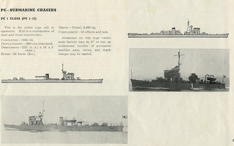 September 7, 1944 0128(H): Lost the escort vessel and nothing more in sight by periscope. I believe the convoy entered the reefs at Latitude 10-50° N. Longitude 118-30 E and continued south in the shoal water close along the west coast of PALAWAN Island which was the direction they were headed when last seen. As our SD radar was still out and this area was well patrolled at night by aircraft decided to remain submerged till daylight.
0822(H): Surfaced for a battery charge. Proceeding north back into area. That was certainly a disappointment to lose out on the only real torpedo targets seen the whole patrol. I think we would have gotten in if the first plane hadn't forced us down at 0400 that morning.
1154(H): Could not raise VIX0 again so transmitted message #4.
1213(H): (AC#36). Sighted an unidentified aircraft, which disappeared below the horizon on a southerly course bearing 075 T.
1630(H): SD radar back in commission.
September 8, 1944 0141(H): (AC#37) Lookouts sighted an unidentified aircraft bearing 240 T, coming from astern and closing. Submerged to avoid detection. Position: Latitude 12-50 N, Longitude 120-07 E.
0248(H): Surfaced.
0529(H): Submerged for day's patrol in northern entrance MINDORO STRAITS.
"Our patrol time was up and Jim Zurcher, the Navigator had the charts broken out to set course for home. Our route would be back through APO EAST PASS, then southward in the SULU SEA to NASO POINT, PANAY. From there we would head due south to ZAMBOANGA, and then along the SULU ARCHIPILAGO to PEARL BANK and SUBUTU PASSAGE off TAWITAWI retracing the route we took coming north at the beginning of the patrol. When clear of SIBUTU Island, we would tale a new route heading southward remaining close to BORNEO and enter MAKASSAR STRAIT, passing close to CAPE MANGKALIHAT, then exiting into the FLORES SEA. We would leave enemy controlled waters passing through the barrier via LOMBOK STRAIT, thence SSW to Freemantle with a brief stop in EXMOUTH GULF, AUSTRALIA to leave excess fuel, or take on a little extra if needed to get us home." (Former C.O.)
1859(H): Surfaced and commenced transit of APO EAST PASSAGE departing from area in accordance with patrol instructions.
1916(H): (SC#28) Made contact by SJ radar on what appeared to be two small vessels bearing 087 T range 1400 yds. During the next hour they drew rapidly ahead and were lost at a range of 6,000 yds. Bearing 190 T. They apparently were patrol craft as they were making about 16 kts, and were quite small. One could be seen ahead for a short while before radar lost contact
2130(H): Completed passage APO EAST PASS and set course for NASO POINT, PANAY via CUYO EAST PASS.
At this point the chase is over. Gunnel was not able to get into a position where an attack was possible.
September 9, 1944 0530(H): Submerged for day's patrol off NASO POINT, PANAY.
1047(H): (SC#29) Sighted two sea trucks bearing 112 T, range about 5 miles, proceeding north close along the coast. Position: Latitude 10-27 N, Longitude 121-49 E.
"They were the small wooden sea trucks, too small for torpedoes." (Former C.O.)
1229(H): (SC#30) Sighted one SCS-1 class special duty sub-chaser bearing 079 T range about 4 miles proceeding north along the coast. Position: Latitude 10-25 N, Longitude 121-51 E.
"Thinking about this today I am sorry now I had not made an effort during the patrol to get clear of things, and try to fix the gun sights. It would have been a makeshift job, as we didn't have the equipment, but it might have been possible to use the gun in this case. This was a type of target made for gunfire. As to torpedoes, we were too far off the track for this contact, and he was going too fast for us to reach a torpedo firing position submerged. Also he was too small to be sure the torpedo would not run under, and too dangerous to get him stirred up should we miss. He had a lot of help around here he could call on for assistance. On sober reflection I decided he wasn't worth it and regretfully let him go his way." (Former C.O.)
1841(H): Surfaced and set course for BLANCA POINT, MINDANAO.
1925(H): Sent message number 5 stating our intention of spending a couple of extra days waiting for traffic in the SULU SEA instead of proceeding homeward.
"Editors note: The original patrol report entries are sparse and incomplete for the period from September 10 through September 15. The events covering these days departing station and heading home have been summarized in the following paragraphs by the former C.O. Capt. O'Neil"
"September 10 through the rest of the week were not productive of targets. During this time the GUNNEL moved slowly southward, lingering at traffic crossroads, hoping to find a juicy target or targets that could be attacked. I wanted very badly to get something before we left these waters. My orders said, "depart area" but I wasn't going to hurry. We spent this day on submerged patrol off BLANCA POINT, MINDANAO Island and that night covered the traffic routes between CEBU and ZAMBOANGA."
"September 11. Back off BLANCA POINT for the day again, surfacing at 1741(H). Since nothing had been found here for two days in this area, we headed back north that night for NASO POINT, PANAY. At 2350(H) we made visual and radar contact (SC#31) on a large ship 20,000 yards to the west steaming on a northerly course, but upon closing for a better look we were disappointed to find it was a properly marked and lighted hospital ship. Position Latitude 090-50 N, Longitude 122-00E, It was probably loaded with raw rubber and other war goods but we had to let it go on its way."
"September 12, (SC#32) At 28 minutes past midnight we picked up radar interference and radar contact at 13,500 yards, which we identified as a U.S. submarine. We made an attempt to exchange identification but before this was certain our
radar couldn't identify ourselves; I didn't want one of our boats shooting at us thinking we were a Japanese patrol. We submerged for an hour at 0219(H) to fix the SJ radar, and when it was back in service we surfaced and remaining on the surface set course for SIBUTU PASSAGE. At 1245(H) and again at 1610(H) we were forced to dive briefly to avoid detection by aircraft (AC#38) and (AC#39) both of which continued on out of sight. Strangely we picked these up with our SD radar on this clear sunshiny day, when it hadn't been able to make contact during the last two weeks of moonlit nights. At 1940(H) as it became dark we commenced transit of the passage west to east between DOC CAN Island and PEARL BANK, and at 2310(H) commenced transit of SIBUTU PASSAGE with BONGAO PEAK and SIBUTU HILL in clear view. As usual I pictured a hundred binoculars watching us and guns being readied, but except for the flickering lights here and there all was quiet (except our engines)."
"September 13. We emerged at 0055(H) into the CELEBESE SEA, completing an uneventful passage and set a course to the southwest to cover traffic lanes between MAKASSAR STRAIT and TARAKAN. Our course took us close to MARATEGA Island and thence southeast to enter MAKASSAR STRAIT close to CAPE MANGKALIHAT. At 0942(H), number 3 main engine developed a bad water leak which left us with only two good engines, one of which had the two large holes in the muffler. We would have to use the noisy one the rest of the way and keep #3 in reserve. At 0944(H) and again at 1110(H) we had to dive to avoid aircraft (AC#40) and (AC#41). The lookouts sighted the first at 9 miles closing, and radar picked up the second at 7 miles. At 2242(H) we passed CAPE MANGKALIHAT abeam to starboard at 10 miles then headed southwestward along the coast."
"September 14. Submerged at 0526(H) and spent the day patrolling in the vicinity of BIRAH BIRAHAN Island in the Straits, about 40 miles off the coast of BORNEO. Upon surfacing that evening we headed south-southeast cutting across the strait making for CAPE WILLIAM, SULAWESI. Nothing was seen or heard during that day or night."
"September 15. At 0215(H) (SC#33) we picked up radar interference bearing 210 T, and exchanged recognition signals and calls by SJ radar. It was a U.S. submarine heading north. Position Latitude 02-03 S, Longitude 118-34 E. We wished him good hunting. The day was spent patrolling submerged off CAPE WILLIAM. We surfaced at 1843(H) and continued South. At 2255(H) (SC#34) made radar contact bearing 296 T, range 13,000 yards position Latitude 04-06 S, Longitude 117-53 E. Happy day! This appeared to be a convoy of ships. Stationed the tracking party, turned to normal approach course and commenced tracking to solve course and speed." (Former C.O.)
September 16, 1944 0026(H): Went to battle stations and made ready torpedo tubes. The contact had developed into a group of four ships on base course 105°T, zigging between 85°T and 125°T at a speed of 8 knots, apparently heading for MAKASSAR CITY. Went ahead full on four engines and commenced approach intending to fire at 2,000 yards on the port beam of the central ship. We had them lined up against the only good patch of horizon in the area, the sky being overcast.
0100(H): With the range 2,500 yards identified the four targets from the bridge as a group of sea trucks. Turned away and secured the tubes. I had previously thought something was peculiar because the maximum range to which we could follow all four of them was 15,000 yards and a medium sized ship can be easily held at 24,000 yards with our SJ. Having already wasted 15 torpedoes on shallow draft spit kits I didn't intend to throw away anymore. Our four inch gun was out of commission since we last fired it so we left them and continued south.
"That was our last chance to get something this patrol. I made up my mind the next run was going to be better. I started serious discussions in the wardroom on the way home with a lot of thought on how to keep the machinery and electronics in better health; and how to be sure the torpedoes ran better. I determined also to try to get a more productive area assigned to work in". (Former C.O.)
0615(H): Sighted SIBIRU ISLAND on the starboard bow, range about 12 miles. Set course for LOMBOK STRAIT.
0945(H): (AC#42) Aircraft contact on the SD radar at 8 miles which commenced to open slowly as we submerged. Position: Latitude 05-39 S, Longitude 117-00 E.
1013(H): Surfaced.
1840(H): Picked up LOMBOK and BALI Islands by SJ radar range 100,000 yards on either bow.
2155(H): Put all four main engines on the line and commenced transit LOMBOK STRAIT favoring the BALI side of the channel.
"We had been warned there was a possibility the Japanese had or would place guns on the LOMBOK Island shore. In my experience in previous patrols in other submarines passing through LOMBOK STRAIT we had never had evidence of weapons installed on shore. It was quiet this night (except for us). Not long after this the Japanese started shooting with a battery of 6-in. guns at our submarines they sighted passing through here. They had no success with the possible exception, during the last month of the war, of the USS BULLHEAD the last American submarine we lost. They were last seen and heard of in or near this strait and might have been sunk by gunfire, although an air attack is more likely. The high mountain of BALI blanked out the SD radar and prevented early warning of aircraft. The strait was deep water throughout its length and about 15 miles wide at its narrowest, and due to strong currents usually required passage on the surface. Happily that made it difficult if not impossible to mine. I never experienced problems but I never was able to relax and enjoy the exotic scenery." (Former C.O.)
September 17, 1944 0000(H): Completed transit of LOMBOK STRAIT, set course for the bombing restriction lane. No patrols encountered.
"We resumed two engine cruising speed for the rest of the journey." (Former C.O.)
0613(H): Submerged for a trim.
0632(H): Surfaced.
0942(H): Sent message number 6.
September 18, 1944 0130(H): (SC#35) Picked up radar interference bearing 190 T from an SJ Radar on a friendly submarine. Position: Latitude 15-15 S, Longitude 114-35 E.
0202(H): Completed exchange of recognition signals by keying the radar, but unable to exchange calls as the signal faded out, still ahead.
0326(H): (SC#36) Sighted a green flare bearing 190 T range about 15 miles and at the same time picked up SJ radar interference and what appeared to be a challenge by radar on the same bearing. Answered with one green flare.
0335(H): Succeeded in answering challenge and exchanging calls by radar with a U.S. Submarine bound north position Latitude 15-38 N, Longitude 114-25 E.
"It would have been an interesting note for history to identify these boats heading north but for security reasons they couldn't be identified in the patrol report at the time it was written, and unfortunately I don't remember now who they were. (Former C.O.)
1200(H): Position Latitude 17-31 S, Longitude 113-47 E
September 19, 1944 0908)H): Sighted land through the high periscope and identified as VLAMING HEAD, Northwest Cape, Australia.
1120(H): Commenced entry EXMOUTH GULF, Australia.
1319(H):Moored port side to fuel barge, Exmouth Gulf, and found he was slowly but surely sinking. At the time of our arrival the crew were sitting patiently on deck measuring the distance they would have to swim for their pumps were as usual broken down.
We rigged a hose from our trim line suction in the forward battery and commenced taking a suction on his pump room with our drain pump, as I didn't see any way we could get home unless we could keep him afloat and take fuel on. Then we ordered the shore station to send out hose and gasoline for their pump and by 1500(H) the extra pump was rigged and the water level was going down.
1858(H): The barge crew finally had their fuel pump out of water and in commission so commenced taking on fuel.
2146(H): Underway, having received about 5,000 gallons diesel fuel. As we cast off our lines I heard one of the barge crew state the water level was rising again.
2340(H): Departed Exmouth Gulf, set course in bombing restriction lane for Fremantle, W.A.
September 20, 1944 0053(H): (SC#38) Picked up radar interference bearing 270°T. Exchanged calls and identification signals with another U.S. submarine proceeding into Exmouth Gulf for fuel. Notified him of the difficulties he would encounter, but as our fuel was just enough to get us back and I felt sure he would arrive before the barge sank did not return to offer help with fuel.
0235(H): Sent message number 7.
September 22, 1944 Arrived Fremantle, W.A. completing this vessel's sixth war patrol.
Epilogue
The captain made several notations in his patrol report under the heading "Health and Habitability".
The food carried was good and of sufficient variety. It was a very pleasant experience for the commanding officer after subsisting on Australian beef for a year in this area to once again eat American meat supplied by the recently arrived tender. Not much can be said for the preparation of the food as three unimaginative cooks and the Navy cookbook is a bad combination for even the hardest working commissary officers.
Habitability was very poor and the lack of air conditioning was keenly felt because the area assigned required many days of submerged running. One does not realize the blessing in disguise afforded by air conditioning until a patrol is made without it in these waters. It takes a lot out of a person to spend day after day gasping for breath and dripping with sweat.
Under the "Personnel" section he had these comments:
This is the third consecutive patrol made by this vessel in which the results were negligible, yet the morale of the crew is excellent and all hands are ready to get out and get going again to make up for lost time.
Both officers and crew performed their duty in an excellent manner.
It is deeply regretted that Rudolph William Velle, MoMM1c, USN, was lost over the side; but as he was uninjured, a good swimmer and close to land, it is felt that his chances of survival are excellent. It is the hope of all hands that he escaped detection by the Japs and assuming they are thinly spread in this area his chances of reaching friendly hands is believed good. It turns out that Velle did make it to land by swimming approximately 14 miles. He made contact with friendly natives and was eventually picked up by another American submarine and returned to active duty.
September 7, 1944 0128(H): Lost the escort vessel and nothing more in sight by periscope. I believe the convoy entered the reefs at Latitude 10-50° N. Longitude 118-30 E and continued south in the shoal water close along the west coast of PALAWAN Island which was the direction they were headed when last seen. As our SD radar was still out and this area was well patrolled at night by aircraft decided to remain submerged till daylight.
0822(H): Surfaced for a battery charge. Proceeding north back into area. That was certainly a disappointment to lose out on the only real torpedo targets seen the whole patrol. I think we would have gotten in if the first plane hadn't forced us down at 0400 that morning.
1154(H): Could not raise VIX0 again so transmitted message #4.
1213(H): (AC#36). Sighted an unidentified aircraft, which disappeared below the horizon on a southerly course bearing 075 T.
1630(H): SD radar back in commission.
September 8, 1944 0141(H): (AC#37) Lookouts sighted an unidentified aircraft bearing 240 T, coming from astern and closing. Submerged to avoid detection. Position: Latitude 12-50 N, Longitude 120-07 E.
0248(H): Surfaced.
0529(H): Submerged for day's patrol in northern entrance MINDORO STRAITS.
"Our patrol time was up and Jim Zurcher, the Navigator had the charts broken out to set course for home. Our route would be back through APO EAST PASS, then southward in the SULU SEA to NASO POINT, PANAY. From there we would head due south to ZAMBOANGA, and then along the SULU ARCHIPILAGO to PEARL BANK and SUBUTU PASSAGE off TAWITAWI retracing the route we took coming north at the beginning of the patrol. When clear of SIBUTU Island, we would tale a new route heading southward remaining close to BORNEO and enter MAKASSAR STRAIT, passing close to CAPE MANGKALIHAT, then exiting into the FLORES SEA. We would leave enemy controlled waters passing through the barrier via LOMBOK STRAIT, thence SSW to Freemantle with a brief stop in EXMOUTH GULF, AUSTRALIA to leave excess fuel, or take on a little extra if needed to get us home." (Former C.O.)
1859(H): Surfaced and commenced transit of APO EAST PASSAGE departing from area in accordance with patrol instructions.
1916(H): (SC#28) Made contact by SJ radar on what appeared to be two small vessels bearing 087 T range 1400 yds. During the next hour they drew rapidly ahead and were lost at a range of 6,000 yds. Bearing 190 T. They apparently were patrol craft as they were making about 16 kts, and were quite small. One could be seen ahead for a short while before radar lost contact
2130(H): Completed passage APO EAST PASS and set course for NASO POINT, PANAY via CUYO EAST PASS.
At this point the chase is over. Gunnel was not able to get into a position where an attack was possible.
September 9, 1944 0530(H): Submerged for day's patrol off NASO POINT, PANAY.
1047(H): (SC#29) Sighted two sea trucks bearing 112 T, range about 5 miles, proceeding north close along the coast. Position: Latitude 10-27 N, Longitude 121-49 E.
"They were the small wooden sea trucks, too small for torpedoes." (Former C.O.)
1229(H): (SC#30) Sighted one SCS-1 class special duty sub-chaser bearing 079 T range about 4 miles proceeding north along the coast. Position: Latitude 10-25 N, Longitude 121-51 E.
"Thinking about this today I am sorry now I had not made an effort during the patrol to get clear of things, and try to fix the gun sights. It would have been a makeshift job, as we didn't have the equipment, but it might have been possible to use the gun in this case. This was a type of target made for gunfire. As to torpedoes, we were too far off the track for this contact, and he was going too fast for us to reach a torpedo firing position submerged. Also he was too small to be sure the torpedo would not run under, and too dangerous to get him stirred up should we miss. He had a lot of help around here he could call on for assistance. On sober reflection I decided he wasn't worth it and regretfully let him go his way." (Former C.O.)
1841(H): Surfaced and set course for BLANCA POINT, MINDANAO.
1925(H): Sent message number 5 stating our intention of spending a couple of extra days waiting for traffic in the SULU SEA instead of proceeding homeward.
"Editors note: The original patrol report entries are sparse and incomplete for the period from September 10 through September 15. The events covering these days departing station and heading home have been summarized in the following paragraphs by the former C.O. Capt. O'Neil"
"September 10 through the rest of the week were not productive of targets. During this time the GUNNEL moved slowly southward, lingering at traffic crossroads, hoping to find a juicy target or targets that could be attacked. I wanted very badly to get something before we left these waters. My orders said, "depart area" but I wasn't going to hurry. We spent this day on submerged patrol off BLANCA POINT, MINDANAO Island and that night covered the traffic routes between CEBU and ZAMBOANGA."
"September 11. Back off BLANCA POINT for the day again, surfacing at 1741(H). Since nothing had been found here for two days in this area, we headed back north that night for NASO POINT, PANAY. At 2350(H) we made visual and radar contact (SC#31) on a large ship 20,000 yards to the west steaming on a northerly course, but upon closing for a better look we were disappointed to find it was a properly marked and lighted hospital ship. Position Latitude 090-50 N, Longitude 122-00E, It was probably loaded with raw rubber and other war goods but we had to let it go on its way."
"September 12, (SC#32) At 28 minutes past midnight we picked up radar interference and radar contact at 13,500 yards, which we identified as a U.S. submarine. We made an attempt to exchange identification but before this was certain our
radar couldn't identify ourselves; I didn't want one of our boats shooting at us thinking we were a Japanese patrol. We submerged for an hour at 0219(H) to fix the SJ radar, and when it was back in service we surfaced and remaining on the surface set course for SIBUTU PASSAGE. At 1245(H) and again at 1610(H) we were forced to dive briefly to avoid detection by aircraft (AC#38) and (AC#39) both of which continued on out of sight. Strangely we picked these up with our SD radar on this clear sunshiny day, when it hadn't been able to make contact during the last two weeks of moonlit nights. At 1940(H) as it became dark we commenced transit of the passage west to east between DOC CAN Island and PEARL BANK, and at 2310(H) commenced transit of SIBUTU PASSAGE with BONGAO PEAK and SIBUTU HILL in clear view. As usual I pictured a hundred binoculars watching us and guns being readied, but except for the flickering lights here and there all was quiet (except our engines)."
"September 13. We emerged at 0055(H) into the CELEBESE SEA, completing an uneventful passage and set a course to the southwest to cover traffic lanes between MAKASSAR STRAIT and TARAKAN. Our course took us close to MARATEGA Island and thence southeast to enter MAKASSAR STRAIT close to CAPE MANGKALIHAT. At 0942(H), number 3 main engine developed a bad water leak which left us with only two good engines, one of which had the two large holes in the muffler. We would have to use the noisy one the rest of the way and keep #3 in reserve. At 0944(H) and again at 1110(H) we had to dive to avoid aircraft (AC#40) and (AC#41). The lookouts sighted the first at 9 miles closing, and radar picked up the second at 7 miles. At 2242(H) we passed CAPE MANGKALIHAT abeam to starboard at 10 miles then headed southwestward along the coast."
"September 14. Submerged at 0526(H) and spent the day patrolling in the vicinity of BIRAH BIRAHAN Island in the Straits, about 40 miles off the coast of BORNEO. Upon surfacing that evening we headed south-southeast cutting across the strait making for CAPE WILLIAM, SULAWESI. Nothing was seen or heard during that day or night."
"September 15. At 0215(H) (SC#33) we picked up radar interference bearing 210 T, and exchanged recognition signals and calls by SJ radar. It was a U.S. submarine heading north. Position Latitude 02-03 S, Longitude 118-34 E. We wished him good hunting. The day was spent patrolling submerged off CAPE WILLIAM. We surfaced at 1843(H) and continued South. At 2255(H) (SC#34) made radar contact bearing 296 T, range 13,000 yards position Latitude 04-06 S, Longitude 117-53 E. Happy day! This appeared to be a convoy of ships. Stationed the tracking party, turned to normal approach course and commenced tracking to solve course and speed." (Former C.O.)
September 16, 1944 0026(H): Went to battle stations and made ready torpedo tubes. The contact had developed into a group of four ships on base course 105°T, zigging between 85°T and 125°T at a speed of 8 knots, apparently heading for MAKASSAR CITY. Went ahead full on four engines and commenced approach intending to fire at 2,000 yards on the port beam of the central ship. We had them lined up against the only good patch of horizon in the area, the sky being overcast.
0100(H): With the range 2,500 yards identified the four targets from the bridge as a group of sea trucks. Turned away and secured the tubes. I had previously thought something was peculiar because the maximum range to which we could follow all four of them was 15,000 yards and a medium sized ship can be easily held at 24,000 yards with our SJ. Having already wasted 15 torpedoes on shallow draft spit kits I didn't intend to throw away anymore. Our four inch gun was out of commission since we last fired it so we left them and continued south.
"That was our last chance to get something this patrol. I made up my mind the next run was going to be better. I started serious discussions in the wardroom on the way home with a lot of thought on how to keep the machinery and electronics in better health; and how to be sure the torpedoes ran better. I determined also to try to get a more productive area assigned to work in". (Former C.O.)
0615(H): Sighted SIBIRU ISLAND on the starboard bow, range about 12 miles. Set course for LOMBOK STRAIT.
0945(H): (AC#42) Aircraft contact on the SD radar at 8 miles which commenced to open slowly as we submerged. Position: Latitude 05-39 S, Longitude 117-00 E.
1013(H): Surfaced.
1840(H): Picked up LOMBOK and BALI Islands by SJ radar range 100,000 yards on either bow.
2155(H): Put all four main engines on the line and commenced transit LOMBOK STRAIT favoring the BALI side of the channel.
"We had been warned there was a possibility the Japanese had or would place guns on the LOMBOK Island shore. In my experience in previous patrols in other submarines passing through LOMBOK STRAIT we had never had evidence of weapons installed on shore. It was quiet this night (except for us). Not long after this the Japanese started shooting with a battery of 6-in. guns at our submarines they sighted passing through here. They had no success with the possible exception, during the last month of the war, of the USS BULLHEAD the last American submarine we lost. They were last seen and heard of in or near this strait and might have been sunk by gunfire, although an air attack is more likely. The high mountain of BALI blanked out the SD radar and prevented early warning of aircraft. The strait was deep water throughout its length and about 15 miles wide at its narrowest, and due to strong currents usually required passage on the surface. Happily that made it difficult if not impossible to mine. I never experienced problems but I never was able to relax and enjoy the exotic scenery." (Former C.O.)
September 17, 1944 0000(H): Completed transit of LOMBOK STRAIT, set course for the bombing restriction lane. No patrols encountered.
"We resumed two engine cruising speed for the rest of the journey." (Former C.O.)
0613(H): Submerged for a trim.
0632(H): Surfaced.
0942(H): Sent message number 6.
September 18, 1944 0130(H): (SC#35) Picked up radar interference bearing 190 T from an SJ Radar on a friendly submarine. Position: Latitude 15-15 S, Longitude 114-35 E.
0202(H): Completed exchange of recognition signals by keying the radar, but unable to exchange calls as the signal faded out, still ahead.
0326(H): (SC#36) Sighted a green flare bearing 190 T range about 15 miles and at the same time picked up SJ radar interference and what appeared to be a challenge by radar on the same bearing. Answered with one green flare.
0335(H): Succeeded in answering challenge and exchanging calls by radar with a U.S. Submarine bound north position Latitude 15-38 N, Longitude 114-25 E.
"It would have been an interesting note for history to identify these boats heading north but for security reasons they couldn't be identified in the patrol report at the time it was written, and unfortunately I don't remember now who they were. (Former C.O.)
1200(H): Position Latitude 17-31 S, Longitude 113-47 E
September 19, 1944 0908)H): Sighted land through the high periscope and identified as VLAMING HEAD, Northwest Cape, Australia.
1120(H): Commenced entry EXMOUTH GULF, Australia.
1319(H):Moored port side to fuel barge, Exmouth Gulf, and found he was slowly but surely sinking. At the time of our arrival the crew were sitting patiently on deck measuring the distance they would have to swim for their pumps were as usual broken down.
We rigged a hose from our trim line suction in the forward battery and commenced taking a suction on his pump room with our drain pump, as I didn't see any way we could get home unless we could keep him afloat and take fuel on. Then we ordered the shore station to send out hose and gasoline for their pump and by 1500(H) the extra pump was rigged and the water level was going down.
1858(H): The barge crew finally had their fuel pump out of water and in commission so commenced taking on fuel.
2146(H): Underway, having received about 5,000 gallons diesel fuel. As we cast off our lines I heard one of the barge crew state the water level was rising again.
2340(H): Departed Exmouth Gulf, set course in bombing restriction lane for Fremantle, W.A.
September 20, 1944 0053(H): (SC#38) Picked up radar interference bearing 270°T. Exchanged calls and identification signals with another U.S. submarine proceeding into Exmouth Gulf for fuel. Notified him of the difficulties he would encounter, but as our fuel was just enough to get us back and I felt sure he would arrive before the barge sank did not return to offer help with fuel.
0235(H): Sent message number 7.
September 22, 1944 Arrived Fremantle, W.A. completing this vessel's sixth war patrol.
Epilogue
The captain made several notations in his patrol report under the heading "Health and Habitability".
The food carried was good and of sufficient variety. It was a very pleasant experience for the commanding officer after subsisting on Australian beef for a year in this area to once again eat American meat supplied by the recently arrived tender. Not much can be said for the preparation of the food as three unimaginative cooks and the Navy cookbook is a bad combination for even the hardest working commissary officers.
Habitability was very poor and the lack of air conditioning was keenly felt because the area assigned required many days of submerged running. One does not realize the blessing in disguise afforded by air conditioning until a patrol is made without it in these waters. It takes a lot out of a person to spend day after day gasping for breath and dripping with sweat.
Under the "Personnel" section he had these comments:
This is the third consecutive patrol made by this vessel in which the results were negligible, yet the morale of the crew is excellent and all hands are ready to get out and get going again to make up for lost time.
Both officers and crew performed their duty in an excellent manner.
It is deeply regretted that Rudolph William Velle, MoMM1c, USN, was lost over the side; but as he was uninjured, a good swimmer and close to land, it is felt that his chances of survival are excellent. It is the hope of all hands that he escaped detection by the Japs and assuming they are thinly spread in this area his chances of reaching friendly hands is believed good. It turns out that Velle did make it to land by swimming approximately 14 miles. He made contact with friendly natives and was eventually picked up by another American submarine and returned to active duty.
 Patrol Statistics
Miles steamed = 11,227
Fuel Oil expended = 140,780
Patrol Length = 55 Days
Torpedoes Remaining = 9
Fuel Remaining = 4,300
Provisions (days) = 10
Endurance Factor Ending Patrol = Fuel and operational order.
Of the 55 days spent at sea, she spent 30 days submerged !
Patrol Statistics
Miles steamed = 11,227
Fuel Oil expended = 140,780
Patrol Length = 55 Days
Torpedoes Remaining = 9
Fuel Remaining = 4,300
Provisions (days) = 10
Endurance Factor Ending Patrol = Fuel and operational order.
Of the 55 days spent at sea, she spent 30 days submerged !
 Adams, Lavelle, Lopatin, Glave, "Moe"
Relaxing on the beach at the Royal Hawaiian Hotel in Hawaii after another successful patrol.
Adams, Lavelle, Lopatin, Glave, "Moe"
Relaxing on the beach at the Royal Hawaiian Hotel in Hawaii after another successful patrol.
 Mac, Moe and Mr. Leidholdt

|